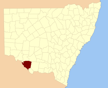
Wakool County

Wakool County
Wakool
New South Wales
Wakool NSW.PNG
Location in New South Wales
Lands administrative divisions around Wakool
Caira Caira Waradgery
Tatchera (Vic) Wakool Townsend
Tatchera (Vic) Gunbower (Vic) Cadell

Wakool County is one of the 141 Cadastral divisions of New South Wales. It contains the town of Wakool.

The name Wakool is believed to be derived from a local Aboriginal word.[1]

Parishes within this county

A full list of parishes found within this county; their current LGA and mapping coordinates to the approximate centre of each location is as follows:

Parish LGA Coordinates
Baldon Conargo Shire Council 34°55′54″S 144°09′04″E / 34.93167°S 144.15111°E / -34.93167; 144.15111 (Baldon)
Balpool Council of the Shire of Wakool 35°13′54″S 144°22′04″E / 35.23167°S 144.36778°E / -35.23167; 144.36778 (Balpool)
Barham Council of the Shire of Wakool 35°36′54″S 144°09′04″E / 35.615°S 144.15111°E / -35.615; 144.15111 (Barham)
Barrabu Council of the Shire of Wakool 35°11′54″S 144°16′04″E / 35.19833°S 144.26778°E / -35.19833; 144.26778 (Barrabu)
Belmore Council of the Shire of Wakool 35°24′54″S 144°00′04″E / 35.415°S 144.00111°E / -35.415; 144.00111 (Belmore)
Benjee Council of the Shire of Wakool 35°03′54″S 144°08′04″E / 35.065°S 144.13444°E / -35.065; 144.13444 (Benjee)
Berambong Council of the Shire of Wakool 35°01′54″S 143°57′04″E / 35.03167°S 143.95111°E / -35.03167; 143.95111 (Berambong)
Beremegad Council of the Shire of Wakool 35°25′54″S 144°09′04″E / 35.43167°S 144.15111°E / -35.43167; 144.15111 (Beremegad)
Binbinette Council of the Shire of Wakool 34°59′54″S 143°53′04″E / 34.99833°S 143.88444°E / -34.99833; 143.88444 (Binbinette)
Bookit Council of the Shire of Wakool 35°29′54″S 144°19′04″E / 35.49833°S 144.31778°E / -35.49833; 144.31778 (Bookit)
Boyd Council of the Shire of Wakool 35°13′54″S 144°05′04″E / 35.23167°S 144.08444°E / -35.23167; 144.08444 (Boyd)
Bundyulumblah Conargo Shire Council 35°01′54″S 144°31′04″E / 35.03167°S 144.51778°E / -35.03167; 144.51778 (Bundyulumblah)
Bungunyah Council of the Shire of Wakool 35°09′54″S 143°25′04″E / 35.165°S 143.41778°E / -35.165; 143.41778 (Bungunyah)
Burbagadah Council of the Shire of Wakool 35°07′54″S 144°08′04″E / 35.13167°S 144.13444°E / -35.13167; 144.13444 (Burbagadah)
Burrawang Council of the Shire of Wakool 34°59′54″S 143°39′04″E / 34.99833°S 143.65111°E / -34.99833; 143.65111 (Burrawang)
Bymue Council of the Shire of Wakool 35°05′54″S 143°24′04″E / 35.09833°S 143.40111°E / -35.09833; 143.40111 (Bymue)
Cangan Council of the Shire of Wakool 35°41′54″S 144°18′04″E / 35.69833°S 144.30111°E / -35.69833; 144.30111 (Cangan)
Caroonboon Conargo Shire Council 34°55′54″S 144°20′04″E / 34.93167°S 144.33444°E / -34.93167; 144.33444 (Caroonboon)
Chowar Council of the Shire of Wakool 35°20′54″S 144°21′04″E / 35.34833°S 144.35111°E / -35.34833; 144.35111 (Chowar)
Cobwell Council of the Shire of Wakool 35°29′54″S 144°07′04″E / 35.49833°S 144.11778°E / -35.49833; 144.11778 (Cobwell)
Cockran Council of the Shire of Wakool 35°21′54″S 144°27′04″E / 35.365°S 144.45111°E / -35.365; 144.45111 (Cockran)
Colvin Council of the Shire of Wakool 35°02′54″S 144°19′04″E / 35.04833°S 144.31778°E / -35.04833; 144.31778 (Colvin)
Condoulpe Council of the Shire of Wakool 34°49′54″S 143°38′04″E / 34.83167°S 143.63444°E / -34.83167; 143.63444 (Condoulpe)
Coobool Council of the Shire of Wakool 35°10′54″S 143°45′04″E / 35.18167°S 143.75111°E / -35.18167; 143.75111 (Coobool)
Coonamit Council of the Shire of Wakool 35°10′54″S 143°39′04″E / 35.18167°S 143.65111°E / -35.18167; 143.65111 (Coonamit)
Cootnite Conargo Shire Council 35°10′54″S 144°31′04″E / 35.18167°S 144.51778°E / -35.18167; 144.51778 (Cootnite)
Corry Council of the Shire of Wakool 35°29′54″S 144°23′04″E / 35.49833°S 144.38444°E / -35.49833; 144.38444 (Corry)
Cunninyeuk Council of the Shire of Wakool 35°16′54″S 143°54′04″E / 35.28167°S 143.90111°E / -35.28167; 143.90111 (Cunninyeuk)
Currpool Council of the Shire of Wakool 35°15′54″S 143°38′04″E / 35.265°S 143.63444°E / -35.265; 143.63444 (Currpool)
Danberry Council of the Shire of Wakool 35°35′54″S 144°15′04″E / 35.59833°S 144.25111°E / -35.59833; 144.25111 (Danberry)
Darlot Council of the Shire of Wakool 35°00′54″S 144°25′04″E / 35.015°S 144.41778°E / -35.015; 144.41778 (Darlot)
Firebrace Conargo Shire Council 34°55′54″S 144°30′04″E / 34.93167°S 144.50111°E / -34.93167; 144.50111 (Firebrace)
Genoe Council of the Shire of Wakool 35°03′54″S 143°30′04″E / 35.065°S 143.50111°E / -35.065; 143.50111 (Genoe)
Gerabbit Council of the Shire of Wakool 35°06′54″S 144°18′04″E / 35.115°S 144.30111°E / -35.115; 144.30111 (Gerabbit)
Gnuie Council of the Shire of Wakool 35°26′54″S 143°54′04″E / 35.44833°S 143.90111°E / -35.44833; 143.90111 (Gnuie)
Gonn Council of the Shire of Wakool 35°29′54″S 144°00′04″E / 35.49833°S 144.00111°E / -35.49833; 144.00111 (Gonn)
Gwynne Conargo Shire Council 34°51′54″S 144°11′04″E / 34.865°S 144.18444°E / -34.865; 144.18444 (Gwynne)
Gynong Council of the Shire of Wakool 35°20′54″S 144°16′04″E / 35.34833°S 144.26778°E / -35.34833; 144.26778 (Gynong)
Hindmarsh Council of the Shire of Wakool 35°05′54″S 144°02′04″E / 35.09833°S 144.03444°E / -35.09833; 144.03444 (Hindmarsh)
Jimaringle Council of the Shire of Wakool 35°19′54″S 144°11′04″E / 35.33167°S 144.18444°E / -35.33167; 144.18444 (Jimaringle)
Kerkeri Council of the Shire of Wakool 34°48′54″S 143°56′04″E / 34.815°S 143.93444°E / -34.815; 143.93444 (Kerkeri)
Kirrabirri Conargo Shire Council 35°06′54″S 144°31′04″E / 35.115°S 144.51778°E / -35.115; 144.51778 (Kirrabirri)
Kyalite Council of the Shire of Wakool 34°55′54″S 143°33′04″E / 34.93167°S 143.55111°E / -34.93167; 143.55111 (Kyalite)
Landale Council of the Shire of Wakool 35°02′54″S 144°00′04″E / 35.04833°S 144.00111°E / -35.04833; 144.00111 (Landale)
Liewa Council of the Shire of Wakool 34°59′54″S 143°30′04″E / 34.99833°S 143.50111°E / -34.99833; 143.50111 (Liewa)
Lintot Council of the Shire of Wakool 34°49′54″S 143°44′04″E / 34.83167°S 143.73444°E / -34.83167; 143.73444 (Lintot)
Lyle Council of the Shire of Wakool 34°59′54″S 144°00′04″E / 34.99833°S 144.00111°E / -34.99833; 144.00111 (Lyle)
Mallan Council of the Shire of Wakool 35°03′54″S 143°45′04″E / 35.065°S 143.75111°E / -35.065; 143.75111 (Mallan)
Mallee Council of the Shire of Wakool 34°54′54″S 143°23′04″E / 34.915°S 143.38444°E / -34.915; 143.38444 (Mallee)
Mein Council of the Shire of Wakool 34°54′54″S 143°57′04″E / 34.915°S 143.95111°E / -34.915; 143.95111 (Mein)
Mellool Council of the Shire of Wakool 35°23′54″S 143°49′04″E / 35.39833°S 143.81778°E / -35.39833; 143.81778 (Mellool)
Merran Council of the Shire of Wakool 35°15′54″S 143°44′04″E / 35.265°S 143.73444°E / -35.265; 143.73444 (Merran)
Merwin Council of the Shire of Wakool 34°48′54″S 143°50′04″E / 34.815°S 143.83444°E / -34.815; 143.83444 (Merwin)
Mia Mia Council of the Shire of Wakool 35°33′54″S 144°17′04″E / 35.565°S 144.28444°E / -35.565; 144.28444 (Mia Mia)
Milleu Council of the Shire of Wakool 34°57′54″S 143°22′04″E / 34.965°S 143.36778°E / -34.965; 143.36778 (Milleu)
Miranda Conargo Shire Council 34°51′54″S 144°30′04″E / 34.865°S 144.50111°E / -34.865; 144.50111 (Miranda)
Moolpa Council of the Shire of Wakool 34°59′54″S 143°34′04″E / 34.99833°S 143.56778°E / -34.99833; 143.56778 (Moolpa)
Moorongatta Council of the Shire of Wakool 35°22′54″S 143°54′04″E / 35.38167°S 143.90111°E / -35.38167; 143.90111 (Moorongatta)
Moulamein South Council of the Shire of Wakool 35°09′54″S 144°02′04″E / 35.165°S 144.03444°E / -35.165; 144.03444 (Moulamein South)
Moulamein Council of the Shire of Wakool 35°02′54″S 144°03′04″E / 35.04833°S 144.05111°E / -35.04833; 144.05111 (Moulamein)
Murga Council of the Shire of Wakool 35°10′54″S 144°24′04″E / 35.18167°S 144.40111°E / -35.18167; 144.40111 (Murga)
Nearroongaroo Council of the Shire of Wakool 35°16′54″S 144°00′04″E / 35.28167°S 144.00111°E / -35.28167; 144.00111 (Nearroongaroo)
Niemur Council of the Shire of Wakool 35°04′54″S 143°51′04″E / 35.08167°S 143.85111°E / -35.08167; 143.85111 (Niemur)
Noorong Council of the Shire of Wakool 35°20′54″S 143°58′04″E / 35.34833°S 143.96778°E / -35.34833; 143.96778 (Noorong)
Nullum Council of the Shire of Wakool 35°07′54″S 144°20′04″E / 35.13167°S 144.33444°E / -35.13167; 144.33444 (Nullum)
Nunnagoyt Council of the Shire of Wakool 35°31′54″S 144°05′04″E / 35.53167°S 144.08444°E / -35.53167; 144.08444 (Nunnagoyt)
Nyang Council of the Shire of Wakool 35°10′54″S 144°11′04″E / 35.18167°S 144.18444°E / -35.18167; 144.18444 (Nyang)
Parquin Council of the Shire of Wakool 35°00′54″S 144°03′04″E / 35.015°S 144.05111°E / -35.015; 144.05111 (Parquin)
Perekerten Council of the Shire of Wakool 34°54′54″S 143°51′04″E / 34.915°S 143.85111°E / -34.915; 143.85111 (Perekerten)
Pevensey Conargo Shire Council 34°49′54″S 144°19′04″E / 34.83167°S 144.31778°E / -34.83167; 144.31778 (Pevensey)
Poon Boon Council of the Shire of Wakool 35°05′54″S 143°34′04″E / 35.09833°S 143.56778°E / -35.09833; 143.56778 (Poon Boon)
Puah Council of the Shire of Wakool 35°09′54″S 143°30′04″E / 35.165°S 143.50111°E / -35.165; 143.50111 (Puah)
Raubelle Conargo Shire Council 34°55′54″S 144°16′04″E / 34.93167°S 144.26778°E / -34.93167; 144.26778 (Raubelle)
Salisbury Council of the Shire of Wakool 34°53′54″S 143°45′04″E / 34.89833°S 143.75111°E / -34.89833; 143.75111 (Salisbury)
Speewa Council of the Shire of Wakool 35°09′54″S 143°34′04″E / 35.165°S 143.56778°E / -35.165; 143.56778 (Speewa)
Tchelery Conargo Shire Council 34°44′54″S 144°09′04″E / 34.74833°S 144.15111°E / -34.74833; 144.15111 (Tchelery)
Thalaka Conargo Shire Council 34°51′54″S 144°18′04″E / 34.865°S 144.30111°E / -34.865; 144.30111 (Thalaka)
Tittil Council of the Shire of Wakool 35°39′54″S 144°14′04″E / 35.665°S 144.23444°E / -35.665; 144.23444 (Tittil)
Tooleybuc Council of the Shire of Wakool 35°01′54″S 143°24′04″E / 35.03167°S 143.40111°E / -35.03167; 143.40111 (Tooleybuc)
Toolmah Council of the Shire of Wakool 35°18′54″S 143°50′04″E / 35.315°S 143.83444°E / -35.315; 143.83444 (Toolmah)
Toolon Council of the Shire of Wakool 35°29′54″S 144°14′04″E / 35.49833°S 144.23444°E / -35.49833; 144.23444 (Toolon)
Towweruk Council of the Shire of Wakool 35°14′54″S 143°54′04″E / 35.24833°S 143.90111°E / -35.24833; 143.90111 (Towweruk)
Turora Council of the Shire of Wakool 34°50′54″S 143°33′04″E / 34.84833°S 143.55111°E / -34.84833; 143.55111 (Turora)
Wakool Council of the Shire of Wakool 34°58′54″S 143°27′04″E / 34.98167°S 143.45111°E / -34.98167; 143.45111 (Wakool)
Wandaradget Council of the Shire of Wakool 35°17′54″S 144°05′04″E / 35.29833°S 144.08444°E / -35.29833; 144.08444 (Wandaradget)
Wetuppa Council of the Shire of Wakool 35°14′54″S 143°51′04″E / 35.24833°S 143.85111°E / -35.24833; 143.85111 (Wetuppa)
Whymoul Council of the Shire of Wakool 35°32′54″S 144°11′04″E / 35.54833°S 144.18444°E / -35.54833; 144.18444 (Whymoul)
Willakool Council of the Shire of Wakool 35°20′54″S 143°43′04″E / 35.34833°S 143.71778°E / -35.34833; 143.71778 (Willakool)
Windouran Council of the Shire of Wakool 35°02′54″S 144°14′04″E / 35.04833°S 144.23444°E / -35.04833; 144.23444 (Windouran)
Winter Council of the Shire of Wakool 34°51′54″S 143°59′04″E / 34.865°S 143.98444°E / -34.865; 143.98444 (Winter)
Wood Council of the Shire of Wakool 34°54′54″S 144°03′04″E / 34.915°S 144.05111°E / -34.915; 144.05111 (Wood)
Woorooma Council of the Shire of Wakool 35°05′54″S 144°12′04″E / 35.09833°S 144.20111°E / -35.09833; 144.20111 (Woorooma)
Worobyan Council of the Shire of Wakool 35°06′54″S 143°56′04″E / 35.115°S 143.93444°E / -35.115; 143.93444 (Worobyan)
Yadabal Council of the Shire of Wakool 35°16′54″S 144°27′04″E / 35.28167°S 144.45111°E / -35.28167; 144.45111 (Yadabal)
Yadchow Council of the Shire of Wakool 35°04′54″S 143°41′04″E / 35.08167°S 143.68444°E / -35.08167; 143.68444 (Yadchow)
Yanga Council of the Shire of Wakool 34°44′54″S 144°08′04″E / 34.74833°S 144.13444°E / -34.74833; 144.13444 (Yanga)
Yarrein Council of the Shire of Wakool 35°01′54″S 143°37′04″E / 35.03167°S 143.61778°E / -35.03167; 143.61778 (Yarrein)
Yellymong Council of the Shire of Wakool 35°18′54″S 143°37′04″E / 35.315°S 143.61778°E / -35.315; 143.61778 (Yellymong)

References

  1. ^ Geographical Names Board of NSW

Wikimedia Foundation. 2010.

Игры ⚽ Поможем решить контрольную работу

Look at other dictionaries:

  • Wakool County, New South Wales — Infobox Australian cadastral name = Wakool state = New South Wales caption = Location in New South Wales near nw = Caira near n = Caira near ne = Waradgery near e = Townsend near se = Cadell near s = Gunbower (Vic) near sw = Tatchera (Vic) near w …   Wikipedia

  • Wakool, New South Wales — Infobox Australian Place | type = town name = Wakool state = nsw caption = The main street of Wakool, looking south towards the general store. The Wakool Hotel is in the foreground. lga = Council of the Shire of Wakool postcode = 2710 est = pop …   Wikipedia

  • County of Gunbower — Gunbower Victoria Location in Victoria Lands administrative divisions around Gunbower …   Wikipedia

  • County of Tatchera — Tatchera Victoria Location in Victoria Lands administrative divisions around Tatchera …   Wikipedia

  • Caira County — Map of all coordinates from Google Map of all coordinates from Bing Export all coordinates as KML …   Wikipedia

  • Cadell County, New South Wales — Infobox Australian cadastral name = Cadell state = New South Wales caption = Location in New South Wales near nw = Wakool near n = Townsend near ne = Townsend near e = Townsend near sw = Gunbower (Vic) near s = Rodney (Vic) near se = Moira (Vic)… …   Wikipedia

  • Cadell County — Map of all coordinates from Google Map of all coordinates from Bing Export all coordinates as KML …   Wikipedia

  • Caira County, New South Wales — Infobox Australian cadastral name = Caira state = New South Wales caption = Location in New South Wales near nw = Taila near n = Kilfera near ne = Waljeers near e = Waradgery near se = Wakool near s = Wakool near sw = Tatchera (Vic) near w =… …   Wikipedia

  • Waradgery County, New South Wales — Infobox Australian cadastral name = Waradgery state = New South Wales caption = Location in New South Wales near nw = Caira near n = Waljeers near ne = Nicholson near e = Sturt near se = Boyd near s = Townsend near sw = Wakool near w =… …   Wikipedia

  • Waradgery County — Map of all coordinates from Google Map of all coordinates from Bing Export all coordinates as KML …   Wikipedia

Share the article and excerpts

Direct link
Do a right-click on the link above
and select “Copy Link”