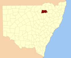
Jamison County

Jamison County
Jamison
New South Wales
Jamison NSW.PNG
Location in New South Wales
Lands administrative divisions around Jamison
Benarba Benarba Courallie
Denham Jamison Murchison
Baradine White Nandewar

Jamison County is one of the 141 Cadastral divisions of New South Wales. It is located to the north of the Namoi River, near Wee Waa.

Jamison County was named in honour of landowner and constitutional reformer Sir John Jamison (1776-1844).[1]

Parishes within this county

A full list of parishes found within this county; their current LGA and mapping coordinates to the approximate centre of each location is as follows:

Parish LGA Coordinates
Belar Narrabri Shire 29°58′54″S 149°34′04″E / 29.98167°S 149.56778°E / -29.98167; 149.56778 (Belar)
Bibil Narrabri Shire 29°58′54″S 149°40′04″E / 29.98167°S 149.66778°E / -29.98167; 149.66778 (Bibil)
Billaboo South Narrabri Shire 30°06′54″S 149°13′04″E / 30.115°S 149.21778°E / -30.115; 149.21778 (Billaboo South)
Billaboo Narrabri Shire 30°00′54″S 149°15′04″E / 30.015°S 149.25111°E / -30.015; 149.25111 (Billaboo)
Bobbiwaa Narrabri Shire 30°09′54″S 149°49′04″E / 30.165°S 149.81778°E / -30.165; 149.81778 (Bobbiwaa)
Bolcarol Narrabri Shire 30°01′54″S 149°19′04″E / 30.03167°S 149.31778°E / -30.03167; 149.31778 (Bolcarol)
Boorah Narrabri Shire 29°56′54″S 149°46′04″E / 29.94833°S 149.76778°E / -29.94833; 149.76778 (Boorah)
Brigalow Narrabri Shire 29°58′54″S 149°19′04″E / 29.98167°S 149.31778°E / -29.98167; 149.31778 (Brigalow)
Bulyeroi Narrabri Shire 29°53′54″S 149°23′04″E / 29.89833°S 149.38444°E / -29.89833; 149.38444 (Bulyeroi)
Bunna Narrabri Shire 29°51′54″S 149°15′04″E / 29.865°S 149.25111°E / -29.865; 149.25111 (Bunna)
Bunyah Narrabri Shire 29°54′54″S 149°28′04″E / 29.915°S 149.46778°E / -29.915; 149.46778 (Bunyah)
Burcarroll Narrabri Shire 30°01′45″S 149°25′21″E / 30.02917°S 149.4225°E / -30.02917; 149.4225 (Burcarroll)
Burren East Walgett Shire 30°04′17″S 149°00′38″E / 30.07139°S 149.01056°E / -30.07139; 149.01056 (Burren East)
Burren Walgett Shire 29°54′54″S 148°55′04″E / 29.915°S 148.91778°E / -29.915; 148.91778 (Burren)
Burrendong Narrabri Shire 29°58′54″S 149°26′04″E / 29.98167°S 149.43444°E / -29.98167; 149.43444 (Burrendong)
Clements Narrabri Shire 29°49′54″S 149°07′04″E / 29.83167°S 149.11778°E / -29.83167; 149.11778 (Clements)
Coolga Walgett Shire 30°14′54″S 148°53′04″E / 30.24833°S 148.88444°E / -30.24833; 148.88444 (Coolga)
Coorong Narrabri Shire 29°59′54″S 149°45′04″E / 29.99833°S 149.75111°E / -29.99833; 149.75111 (Coorong)
Cowimangarah Narrabri Shire 30°03′54″S 150°03′04″E / 30.065°S 150.05111°E / -30.065; 150.05111 (Cowimangarah)
Cubbaroo North Narrabri Shire 30°11′36″S 149°05′31″E / 30.19333°S 149.09194°E / -30.19333; 149.09194 (Cubbaroo North)
Cubbaroo Narrabri Shire 30°17′54″S 148°58′04″E / 30.29833°S 148.96778°E / -30.29833; 148.96778 (Cubbaroo)
Dangar Narrabri Shire 29°49′54″S 149°25′04″E / 29.83167°S 149.41778°E / -29.83167; 149.41778 (Dangar)
Dealwarraldi Walgett Shire 29°59′54″S 149°01′04″E / 29.99833°S 149.01778°E / -29.99833; 149.01778 (Dealwarraldi)
Denham Narrabri Shire 29°59′54″S 149°09′04″E / 29.99833°S 149.15111°E / -29.99833; 149.15111 (Denham)
Dewhurst Walgett Shire 30°03′54″S 148°54′04″E / 30.065°S 148.90111°E / -30.065; 148.90111 (Dewhurst)
Dobikin Narrabri Shire 29°54′54″S 149°40′04″E / 29.915°S 149.66778°E / -29.915; 149.66778 (Dobikin)
Doyle Narrabri Shire 30°07′54″S 149°55′04″E / 30.13167°S 149.91778°E / -30.13167; 149.91778 (Doyle)
Drildool Narrabri Shire 30°14′54″S 149°05′04″E / 30.24833°S 149.08444°E / -30.24833; 149.08444 (Drildool)
Eckford Narrabri Shire 29°53′54″S 149°35′04″E / 29.89833°S 149.58444°E / -29.89833; 149.58444 (Eckford)
Edgeroi Narrabri Shire 29°59′54″S 149°54′04″E / 29.99833°S 149.90111°E / -29.99833; 149.90111 (Edgeroi)
Galathera Narrabri Shire 30°10′54″S 149°40′04″E / 30.18167°S 149.66778°E / -30.18167; 149.66778 (Galathera)
Gehan Narrabri Shire 29°48′54″S 149°38′04″E / 29.815°S 149.63444°E / -29.815; 149.63444 (Gehan)
Gommel Narrabri Shire 30°09′54″S 149°35′04″E / 30.165°S 149.58444°E / -30.165; 149.58444 (Gommel)
Graham Walgett Shire 30°29′54″S 148°56′04″E / 30.49833°S 148.93444°E / -30.49833; 148.93444 (Graham)
Gundemain Narrabri Shire 30°04′54″S 149°30′04″E / 30.08167°S 149.50111°E / -30.08167; 149.50111 (Gundemain)
Helebah Narrabri Shire 30°08′28″S 149°25′03″E / 30.14111°S 149.4175°E / -30.14111; 149.4175 (Helebah)
Jamison Walgett Shire 30°10′54″S 148°54′04″E / 30.18167°S 148.90111°E / -30.18167; 148.90111 (Jamison)
Keera Narrabri Shire 30°05′54″S 149°45′04″E / 30.09833°S 149.75111°E / -30.09833; 149.75111 (Keera)
Long Point Narrabri Shire 30°03′42″S 149°07′59″E / 30.06167°S 149.13306°E / -30.06167; 149.13306 (Long Point)
Manamoi Narrabri Shire 29°48′54″S 149°45′04″E / 29.815°S 149.75111°E / -29.815; 149.75111 (Manamoi)
Markham Narrabri Shire 29°48′54″S 149°16′04″E / 29.815°S 149.26778°E / -29.815; 149.26778 (Markham)
Mellburra Narrabri Shire 30°00′54″S 150°00′04″E / 30.015°S 150.00111°E / -30.015; 150.00111 (Mellburra)
Merah North Narrabri Shire 30°11′54″S 149°12′04″E / 30.19833°S 149.20111°E / -30.19833; 149.20111 (Merah North)
Merah Narrabri Shire 30°14′54″S 149°12′04″E / 30.24833°S 149.20111°E / -30.24833; 149.20111 (Merah)
Meriah Narrabri Shire 30°05′54″S 149°37′04″E / 30.09833°S 149.61778°E / -30.09833; 149.61778 (Meriah)
Millie Narrabri Shire 29°49′54″S 149°11′04″E / 29.83167°S 149.18444°E / -29.83167; 149.18444 (Millie)
Moema Narrabri Shire 30°02′54″S 149°56′04″E / 30.04833°S 149.93444°E / -30.04833; 149.93444 (Moema)
Morgan Walgett Shire 29°53′54″S 149°00′04″E / 29.89833°S 149.00111°E / -29.89833; 149.00111 (Morgan)
Myall Hollow Narrabri Shire 29°54′54″S 149°50′04″E / 29.915°S 149.83444°E / -29.915; 149.83444 (Myall Hollow)
Nowley Narrabri Shire 29°56′54″S 149°11′04″E / 29.94833°S 149.18444°E / -29.94833; 149.18444 (Nowley)
Nundi Narrabri Shire 30°05′54″S 149°52′04″E / 30.09833°S 149.86778°E / -30.09833; 149.86778 (Nundi)
Oreel Walgett Shire 29°44′54″S 148°59′04″E / 29.74833°S 148.98444°E / -29.74833; 148.98444 (Oreel)
Oreel Walgett Shire 29°48′54″S 149°02′04″E / 29.815°S 149.03444°E / -29.815; 149.03444 (Oreel)
Pian Narrabri Shire 30°37′54″S 149°20′04″E / 30.63167°S 149.33444°E / -30.63167; 149.33444 (Pian)
Queerbri Narrabri Shire 30°08′54″S 149°30′04″E / 30.14833°S 149.50111°E / -30.14833; 149.50111 (Queerbri)
Tarlee Narrabri Shire 30°07′54″S 149°45′04″E / 30.13167°S 149.75111°E / -30.13167; 149.75111 (Tarlee)
Thalaba Narrabri Shire 29°51′54″S 149°30′04″E / 29.865°S 149.50111°E / -29.865; 149.50111 (Thalaba)
Tulladunna Narrabri Shire 30°11′49″S 149°22′38″E / 30.19694°S 149.37722°E / -30.19694; 149.37722 (Tulladunna)
Vickery Narrabri Shire 29°55′54″S 149°05′04″E / 29.93167°S 149.08444°E / -29.93167; 149.08444 (Vickery)
Warrambool Narrabri Shire 30°11′47″S 148°59′05″E / 30.19639°S 148.98472°E / -30.19639; 148.98472 (Warrambool)
Waterloo Narrabri Shire 29°52′54″S 149°51′04″E / 29.88167°S 149.85111°E / -29.88167; 149.85111 (Waterloo)
Waugan Narrabri Shire 30°00′54″S 149°39′04″E / 30.015°S 149.65111°E / -30.015; 149.65111 (Waugan)
Weeta Waa Narrabri Shire 30°14′54″S 149°19′04″E / 30.24833°S 149.31778°E / -30.24833; 149.31778 (Weeta Waa)
Woolabrar Narrabri Shire 29°52′54″S 149°45′04″E / 29.88167°S 149.75111°E / -29.88167; 149.75111 (Woolabrar)
Yarranbar Narrabri Shire 29°57′54″S 149°15′04″E / 29.965°S 149.25111°E / -29.965; 149.25111 (Yarranbar)

References

  1. ^ Geographical Names Board of NSW

Wikimedia Foundation. 2010.

Игры ⚽ Нужна курсовая?

Look at other dictionaries:

  • Jamison County, New South Wales — Infobox Australian cadastral name = Jamison state = New South Wales caption = Location in New South Wales near nw = Benarba near n = Benarba near ne = Courallie near e = Murchison near se = Nandewar near s = White near sw = Baradine near w =… …   Wikipedia

  • County Route 574 (Erie County, New York) — County Route 574 Jamison Road Map of the Buffalo area with CR 574 …   Wikipedia

  • Jamison City — Lugar designado por el censo de los Estados Unidos …   Wikipedia Español

  • County Antrim — Contae Aontroma Coontie Antrìm / Countie Antrim Coat of arms …   Wikipedia

  • Jamison City, Pennsylvania — Jamison City is a census designated place in Columbia County, Pennsylvania, United States. The population was 102 at the 2000 census. It is part of the Bloomsburg ndash;Berwick Micropolitan Statistical Area.GeographyJamison City is located at… …   Wikipedia

  • Jamison v. State of Texas — SCOTUSCase Litigants=Jamison v. State of Texas ArgueDate=February 12 ArgueYear=1943 DecideDate=March 8 DecideYear=1943 FullName=Jamison v. State of Texas USVol=318 USPage=413 Citation=63 S. Ct. 669; 87 L. Ed. 869; 1943 U.S. LEXIS 889 Prior=… …   Wikipedia

  • John Jamison — Sir John Jamison (1776 29 June 1844) was an Australian physician, pastoralist, banker, politician, constitutional reformer and public figure.Thomas Jamison, his father, was an impressive person in his own right. A Northern Irishman, Thomas had… …   Wikipedia

  • List of county routes in Erie County, New York (545–580) — County routes in Erie County, New York (545–580) CR 546 • CR 547 • CR 548 • CR 550 • CR 551 • CR 552 • CR 553 • CR 554 • CR 555 • CR 557 •… …   Wikipedia

  • Plumas County, California — County of Plumas   County   Seal …   Wikipedia

  • List of county routes in Erie County, New York (161–192) — County routes in Erie County, New York (161–192) CR 161 • CR 162 • CR 163 • CR 164 • CR 165 • CR 166 • CR 167 • CR 169 • CR 170 • CR 171 •… …   Wikipedia

Share the article and excerpts

Direct link
Do a right-click on the link above
and select “Copy Link”