Dowling County

Dowling County
Dowling
New South Wales
Dowling NSW.PNG
Location in New South Wales
Lands administrative divisions around Dowling
Blaxland Blaxland Cunningham
Franklin Dowling Gipps
Nicholson Cooper Cooper

Dowling County is one of the 141 Cadastral divisions of New South Wales.

Dowling County was named in honour of Judge Sir James Dowling (1787-1844).[1]

Parishes within this county

A full list of parishes found within this county; their current LGA and mapping coordinates to the approximate centre of each location is as follows:

Parish LGA Coordinates
Bimbalingel Lachlan Shire Council 33°18′54″S 146°12′04″E / 33.315°S 146.20111°E / -33.315; 146.20111 (Bimbalingel)
Bimbil Bland Shire Council 33°37′54″S 146°08′04″E / 33.63167°S 146.13444°E / -33.63167; 146.13444 (Bimbil)
Blairgowrie Bland Shire Council 33°37′54″S 146°35′04″E / 33.63167°S 146.58444°E / -33.63167; 146.58444 (Blairgowrie)
Bootoowa Lachlan Shire Council 33°24′54″S 146°11′04″E / 33.415°S 146.18444°E / -33.415; 146.18444 (Bootoowa)
Borapine Lachlan Shire Council 33°18′54″S 146°43′04″E / 33.315°S 146.71778°E / -33.315; 146.71778 (Borapine)
Brewer Lachlan Shire Council 33°25′54″S 146°05′04″E / 33.43167°S 146.08444°E / -33.43167; 146.08444 (Brewer)
Brotheroney Lachlan Shire Council 33°10′54″S 146°44′04″E / 33.18167°S 146.73444°E / -33.18167; 146.73444 (Brotheroney)
Cargelligo Lachlan Shire Council 33°22′54″S 146°23′04″E / 33.38167°S 146.38444°E / -33.38167; 146.38444 (Cargelligo)
Carilla Carrathool Shire Council 33°24′54″S 145°55′04″E / 33.415°S 145.91778°E / -33.415; 145.91778 (Carilla)
Carisbrook Lachlan Shire Council 33°28′54″S 146°05′04″E / 33.48167°S 146.08444°E / -33.48167; 146.08444 (Carisbrook)
Clowery Bland Shire Council 33°42′54″S 146°40′04″E / 33.715°S 146.66778°E / -33.715; 146.66778 (Clowery)
Contarlo Lachlan Shire Council 33°28′54″S 146°10′04″E / 33.48167°S 146.16778°E / -33.48167; 146.16778 (Contarlo)
Currawong Bland Shire Council 33°34′54″S 146°22′04″E / 33.58167°S 146.36778°E / -33.58167; 146.36778 (Currawong)
Curriba Lachlan Shire Council 33°27′54″S 146°41′04″E / 33.465°S 146.68444°E / -33.465; 146.68444 (Curriba)
Currikabakh Bland Shire Council 33°43′54″S 146°30′04″E / 33.73167°S 146.50111°E / -33.73167; 146.50111 (Currikabakh)
Davis Bland Shire Council 33°43′54″S 146°07′04″E / 33.73167°S 146.11778°E / -33.73167; 146.11778 (Davis)
Dowling Carrathool Shire Council 33°32′54″S 146°03′04″E / 33.54833°S 146.05111°E / -33.54833; 146.05111 (Dowling)
Gainbill Lachlan Shire Council 33°23′54″S 146°31′04″E / 33.39833°S 146.51778°E / -33.39833; 146.51778 (Gainbill)
Garryowen Lachlan Shire Council 33°28′54″S 146°19′04″E / 33.48167°S 146.31778°E / -33.48167; 146.31778 (Garryowen)
Geelooma Bland Shire Council 33°36′54″S 146°40′04″E / 33.615°S 146.66778°E / -33.615; 146.66778 (Geelooma)
Guagong Lachlan Shire Council 33°09′54″S 146°37′04″E / 33.165°S 146.61778°E / -33.165; 146.61778 (Guagong)
Gumbagunda Lachlan Shire Council 33°08′54″S 146°29′04″E / 33.14833°S 146.48444°E / -33.14833; 146.48444 (Gumbagunda)
Gurangully Lachlan Shire Council 33°13′54″S 146°24′04″E / 33.23167°S 146.40111°E / -33.23167; 146.40111 (Gurangully)
Jimberoo Bland Shire Council 33°43′54″S 146°13′04″E / 33.73167°S 146.21778°E / -33.73167; 146.21778 (Jimberoo)
Kikoira Bland Shire Council 33°39′54″S 146°40′04″E / 33.665°S 146.66778°E / -33.665; 146.66778 (Kikoira)
Killawarra Lachlan Shire Council 33°26′54″S 146°30′04″E / 33.44833°S 146.50111°E / -33.44833; 146.50111 (Killawarra)
Lachlan Lachlan Shire Council 33°11′54″S 146°20′04″E / 33.19833°S 146.33444°E / -33.19833; 146.33444 (Lachlan)
Merri Merrigal Carrathool Shire Council 33°25′54″S 146°00′04″E / 33.43167°S 146.00111°E / -33.43167; 146.00111 (Merri Merrigal)
Mologone Bland Shire Council 33°37′54″S 146°15′04″E / 33.63167°S 146.25111°E / -33.63167; 146.25111 (Mologone)
Moneybung Carrathool Shire Council 33°29′54″S 146°00′04″E / 33.49833°S 146.00111°E / -33.49833; 146.00111 (Moneybung)
Murrabung Bland Shire Council 33°44′54″S 146°24′04″E / 33.74833°S 146.40111°E / -33.74833; 146.40111 (Murrabung)
Naradhan Bland Shire Council 33°43′54″S 146°18′04″E / 33.73167°S 146.30111°E / -33.73167; 146.30111 (Naradhan)
Narden Lachlan Shire Council 33°22′54″S 146°42′04″E / 33.38167°S 146.70111°E / -33.38167; 146.70111 (Narden)
Narriah Bland Shire Council 33°43′54″S 146°34′04″E / 33.73167°S 146.56778°E / -33.73167; 146.56778 (Narriah)
Regent Lachlan Shire Council 33°26′54″S 146°17′04″E / 33.44833°S 146.28444°E / -33.44833; 146.28444 (Regent)
Rutland Bland Shire Council 33°37′54″S 146°31′04″E / 33.63167°S 146.51778°E / -33.63167; 146.51778 (Rutland)
Tibeaudo Lachlan Shire Council 33°24′54″S 146°33′04″E / 33.415°S 146.55111°E / -33.415; 146.55111 (Tibeaudo)
Tooronga Lachlan Shire Council 33°22′54″S 146°17′04″E / 33.38167°S 146.28444°E / -33.38167; 146.28444 (Tooronga)
Townsend Carrathool Shire Council 33°33′54″S 145°59′04″E / 33.565°S 145.98444°E / -33.565; 145.98444 (Townsend)
Trigalong Lachlan Shire Council 33°11′54″S 146°28′04″E / 33.19833°S 146.46778°E / -33.19833; 146.46778 (Trigalong)
Tuggerabach Lachlan Shire Council 33°28′54″S 146°33′04″E / 33.48167°S 146.55111°E / -33.48167; 146.55111 (Tuggerabach)
Uabba Lachlan Shire Council 33°19′54″S 146°07′04″E / 33.33167°S 146.11778°E / -33.33167; 146.11778 (Uabba)
Ulambong Lachlan Shire Council 33°13′54″S 146°11′04″E / 33.23167°S 146.18444°E / -33.23167; 146.18444 (Ulambong)
Valencia Carrathool Shire Council 33°39′54″S 145°58′04″E / 33.665°S 145.96778°E / -33.665; 145.96778 (Valencia)
Wardry Lachlan Shire Council 33°04′54″S 146°45′04″E / 33.08167°S 146.75111°E / -33.08167; 146.75111 (Wardry)
Whoyeo Lachlan Shire Council 33°18′54″S 146°18′04″E / 33.315°S 146.30111°E / -33.315; 146.30111 (Whoyeo)
Whyaddra Lachlan Shire Council 33°03′54″S 146°38′04″E / 33.065°S 146.63444°E / -33.065; 146.63444 (Whyaddra)
Womboyn Bland Shire Council 33°40′54″S 146°20′04″E / 33.68167°S 146.33444°E / -33.68167; 146.33444 (Womboyn)
Yarrabundry Lachlan Shire Council 33°17′54″S 146°36′04″E / 33.29833°S 146.60111°E / -33.29833; 146.60111 (Yarrabundry)
Yarran Lachlan Shire Council 33°18′54″S 146°31′04″E / 33.315°S 146.51778°E / -33.315; 146.51778 (Yarran)
Yelkin Lachlan Shire Council 33°27′54″S 146°22′04″E / 33.465°S 146.36778°E / -33.465; 146.36778 (Yelkin)

References


Wikimedia Foundation. 2010.

Игры ⚽ Нужен реферат?

Look at other dictionaries:

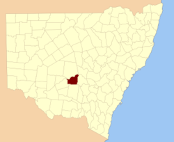
  • Dowling County, New South Wales — Infobox Australian cadastral name = Dowling state = New South Wales caption = Location in New South Wales near nw = Blaxland near n = Blaxland near ne = Cunningham near e = Gipps near se = Cooper near s = Cooper near sw = Nicholson near w =… …   Wikipedia

  • Dowling Catholic High School — Veritas ∙ Fides ∙ Sapientia Truth ∙ Faith ∙ Wisdom Address 1400 Buffalo Road …   Wikipedia

  • Dowling College — logo Motto The Personal College Established 1955 Type Private …   Wikipedia

  • Dowling (surname) — Dowling is an Irish surname. It is an anglacised form representing two unrelated clans: 1 O Dubhlainn, a minor family of County Galway, represented by Richard William Dowling (1838 1867), American Confederate officer. 2 O Duiling, noted as one of …   Wikipedia

  • Dowling Township, Knox County, Nebraska — Dowling Township   Township   Location in Knox County …   Wikipedia

  • Dowling v. United States (1985) — Dowling v. United States Supreme Court of the United States Argued April 17, 1985 Decided June 28, 19 …   Wikipedia

  • Dowling — may refer to: Dowling, Ontario, a community in Canada Dowling v. United States (disambiguation), multiple cases Dowling College, in New York, US Dowling Catholic High School, in Iowa, US 3529 Dowling, an asteroid Dowling (surname), people with… …   Wikipedia

  • County Laois — Contae Laoise Coat of arms Motto: I bp …   Wikipedia

  • Dowling — This interesting surname has two distinct and separate origins. The first is Anglo Irish, being a form of the Old Gaelic O Dunlaing ; the Gaelic prefix O indicating male descendant of , plus the personal byname Dunlaing , of uncertain meaning,… …   Surnames reference

  • County of Ripon — Ripon Victoria Location in Victoria Lands administrative divisions around Ripon …   Wikipedia

Share the article and excerpts

Direct link
Do a right-click on the link above
and select “Copy Link”