- New Jersey Route 170
-
Route 170
Atlantic Avenue
New York AvenueRoute information Maintained by New Jersey Department of Transportation Length: 0.79 mi[1] (1.27 km) Existed: 1957 – by 1988 Major junctions South end:  US 206 in Mansfield Township
North end: US 206 in ColumbusLocation Counties: Burlington Highway system New Jersey State Highway Routes
Interstate and US←  Route 169
Route 171  →
→←  CR 688
CR 691  →
→Route 170 was a short, 0.79-mile (1.27 km) long state highway in Burlington County, New Jersey. The route was a former alignment of U.S. Route 206 and New Jersey Route 39 in the downtown portions of Mansfield Township and Columbus. Route 170 began at an intersection with U.S. Route 206 in Mansfield Township, headed northward along Atlantic Avenue and New York Avenue in Columbus before merging with U.S. Route 206 at a wye connection further north.
The highway was assigned as part of Route 39 in the state highway renumbering in 1927. The route remained intact, receiving a concurrency through the two communities when U.S. Route 206 was assigned in the mid-1930s. The two routes remained intact until the state highway renumbering on January 1, 1953, when Route 39 was decommissioned in favor of just U.S. Route 206. The highway was bypassed in 1957, with Route 206 heading to the outside of the communities. The original alignment became Route 170, and lasted until at least 1988, when it was removed from the state maintenance. The state turned the alignment over to Burlington County, who re-designated it as County Route 690.
Contents
Route description
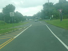 The northern terminus of Route 170 at U.S. Route 206 in Columbus
- This route description is written as the route exists today.
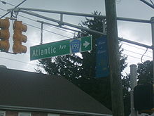
Burlington County Route 690 (also known as Atlantic Avenue) begins at an wye intersection with U.S. Route 206 in the community of Mansfield Township. The route heads northward, intersecting with the southbound portion of the road. Route 690 becomes surrounded by several residential homes for a distance, becoming more commercial as the route heads northward, entering the community of Columbus. Route 690 continues through the business district of Columbus, intersecting with County Route 543 (Main Street) in the center of the community.[2]
At County Route 543, County Route 690 shifts to the east a bit, changing names from Atlantic Avenue to New York Avenue, where it returns to the residential progression in Columbus. The route, which parallels Route 206 to the west, intersects with Locust Avenue, a one-way road towards several local businesses. A short distance after Locust Avenue, Route 690 reaches a gap in the residential homes, turning to fields and rural areas a short distance later. Although the route parallels several homes to the west, the route remains lightly developed, entering another wye at County Route 678, where the route merges into U.S. Route 206 once again in Columbus.[2]
History
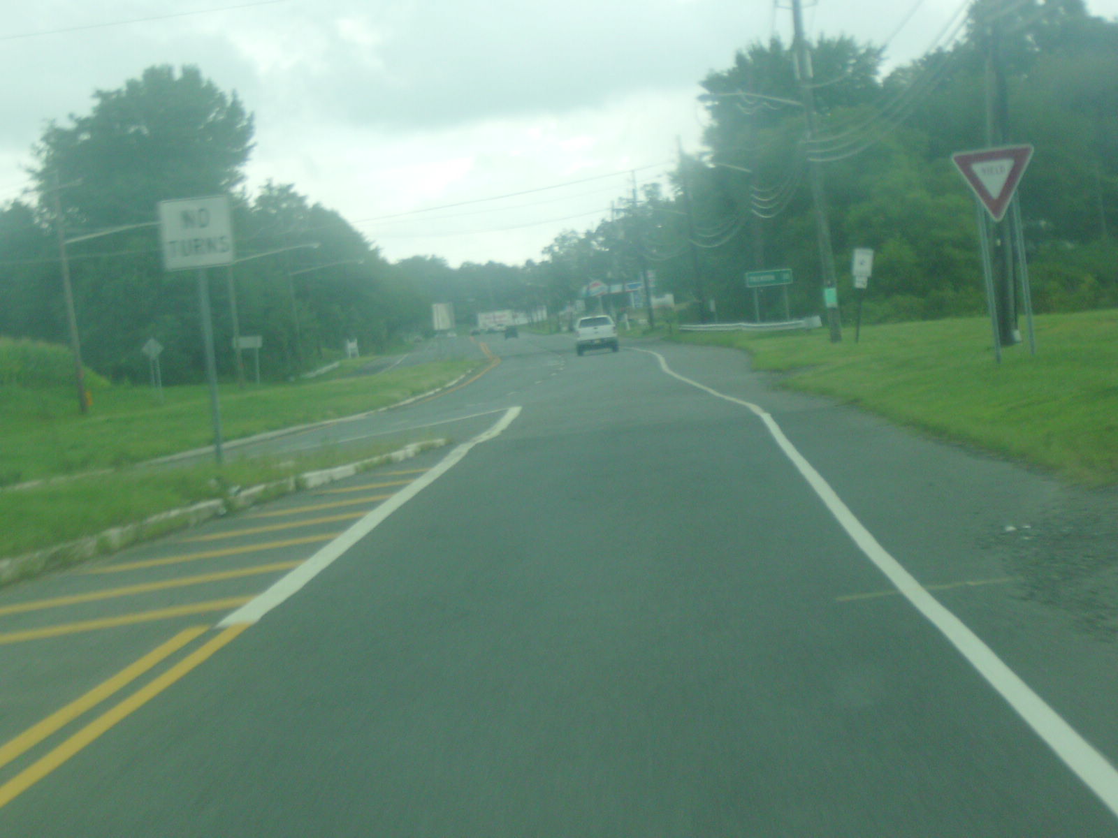
 Blade sign depicting County Route 690, which is what was designated along the alignment after Route 170 was decommissioned
The alignment of Route 170 dates back to the 1927 state highway renumbering as an alignment of New Jersey Route 39.[3][4] When Route 39 was assigned, the route went from U.S. Route 30 and New Jersey Route 54 in Hammonton northward along present-day U.S. Route 206 to County Route 524 in Hamilton Township, where it turned off Route 206 towards the Yardley-Wilburtha Bridge.[5] Route 39 remained intact, and received a large concurrency with U.S. Route 206, when assigned in the mid-1930s.[6] The two remained concurrent for several years,[7] until the second state highway renumbering on January 1, 1953. On that day, Route 39 was decommissioned in its entirety, leaving the alignment fully U.S. Route 206.[8][9] In 1957, the New Jersey State Highway Department built a bypass of U.S. Route 206 around the community of Columbus, heading to the west of the community.[10]
Upon completion of the bypass, Route 206 was replaced by Route 170, which ran along Atlantic Avenue and New York Avenue through the community. The route remained intact for several decades,[11] lasting in state documents until around 1988,[12] when the route was turned over to Burlington County for future maintenance. When the route was turned over, it became Burlington County Route 690.[1]
Major intersections
The entire route was in Burlington County.
Location Mile[1] Destinations Notes Mansfield Township 0.00 US 206 (Disabled American Veterans Highway)Columbus 0.25  CR 543 (Main Street)
0.79 US 206 (Disabled American Veterans Highway)Right-of-way merged back into U.S. Route 206 1.000 mi = 1.609 km; 1.000 km = 0.621 mi See also
 U.S. Roads portal
 New Jersey portal
- New Jersey Route 160
- New Jersey Route 177
References
- ^ a b c "County Route 690 straight line diagram". New Jersey Department of Transportation. http://www.state.nj.us/transportation/refdata/sldiag/03000690__-.pdf. Retrieved September 27, 2009.
- ^ a b Bing Maps/Microsoft Incorporated (2009). Overview map of County Route 690/Old Route 170 (Map). Cartography by NAVTEQ Incorporated. http://www.maps.bing.com/maps/?FORM=Z9LH8#JnJ0cD1wb3MucXBiYm14OHM1d2N2X25lYXIrNCtBdGxhbnRpYytBdmUlMmMrQ29sdW1idXMlMmMrTmV3K0plcnNleSswODAyMiUyYytVbml0ZWQrU3RhdGVzX19fZV8lN2Vwb3MucXBjenRmOHM2NHBoX25lYXIrTmV3K1lvcmsrQXZlJTJjK0NvbHVtYnVzJTJjK05ldytKZXJzZXkrMDgwMjIlMmMrVW5pdGVkK1N0YXRlc19fX2VfJnJ0b3A9MCU3ZTA=. Retrieved September 27, 2009.
- ^ State of New Jersey, Laws of 1927, Chapter 319.
- ^ Williams, Jimmy and Sharon. "1927 New Jersey Road Map". 1920s New Jersey Highways. http://www.jimmyandsharonwilliams.com/njroads/1920s/images/1927_routes.gif. Retrieved 2008-10-08.
- ^ "319". ROUTE NO. 39. Yardley Bridge by-passing Trenton through Bordentown to Da Costa. Beginning at Yardley Bridge thence in a semi-circular path around Trenton, through vicinity of Trenton Junction, Ewingville, Bakersville, Mercerville to Bordentown, Columbus, Vincentown, Red Lion, Indian Mills, Atsion and Da Costa.. New Jersey General Assembly. 1927.
- ^ Mid-West Map Co. (1937). Map of Pennsylvania and New Jersey (Map). http://www.mapsofpa.com/roadcart/1937_1044m.jpg. Retrieved 2009-03-29.
- ^ United States Geological Survey (1947). Newark, New Jersey 1:250,000 topographic map (Map). Cartography by United States Geological Survey.
- ^ 1953 renumbering. New Jersey Department of Highways. http://en.wikisource.org/wiki/1953_New_Jersey_state_highway_renumbering. Retrieved September 27, 2009.
- ^ "New Road Signs Ready in New Jersey". The New York Times. December 16, 1952. http://img123.imageshack.us/img123/6933/19521216newroadsignsreaiu6.jpg. Retrieved September 27, 2009.
- ^ Alpert, Steve; Moraseski, Dan (2009). "NJ 170". Alps Roads. http://www.alpsroads.net/roads/nj/log/9.html#170. Retrieved September 27, 2009.
- ^ Route 170 Straight Line Diagram. New Jersey Department of Transportation. 1985.
- ^ Straight Line Diagrams. New Jersey Department of Transportation. 1988.
External links
Categories:- State highways in New Jersey
- Transportation in Burlington County, New Jersey


Wikimedia Foundation. 2010.