- 14th Street (Hoboken)
-
County Route 670 14th Street/Viaduct Route information Length: 0.66 mi[1] (1.1 km) Highway system County routes in New Jersey
500-series • County routes in Hudson County←  CR 669
CR 671  →
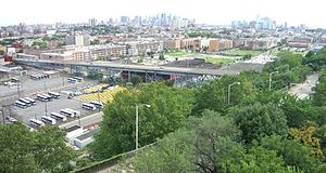
→Fourteenth Street in uptown Hoboken, New Jersey carries the Hudson County designation CR670. The eastern end is the Hudson River while its western portion is known simply as the 14th Street Viaduct. It is at the northern end of the city's urban grid, and one of the east–west streets that allows for two-way traffic. Weehawken Cove is two blocks to the north.
Contents
The Viaduct
The 14th Street Viaduct begins at the intersection of Willow Avenue, and travels perpendicular to the Hudson Palisades in Union City. It ascends to connect to the Wing Viaduct, designated CR 683
 ,[2] which runs along the face of the cliff. Portions of the massive retaining wall were originally parts of the North Hudson County Railway's Hillside Line. At its summit the south wing becomes Paterson Plank Road in Jersey City Heights, while the north wing rises to Manhattan Avenue and Mountain Road. Just north of its lower end is the Willow Avenue Viaduct, which travels over the Hudson Bergen Light Rail and serves local as well as Lincoln Tunnel-bound traffic.[3][4]
Plans were unveiled for improvements to the area beneath the bridge on September 7, 2010, which include a dog run, playground, raised sidewalks and narrower streets for improved pedestrian safety, a block of active recreation space with a multi-use court and two blocks of multi-purpose space that can be used for farmer's markets and other community purposes. The plans also include the closing of east-west blocks of South Marginal Street to vehicular traffic, which was already done with the street in front of the Clearview Cinemas that opened just south of the Viaduct's span in 2009. The plans were part of a $55 million federally-funded improvement project for Hudson County that was spurred by the 2007 collapse of the I-35W Mississippi River Bridge in Minneapolis, Minnesota.[5][6]
Bus
New Jersey Transit operates bus routes 22, 89 (to North Hudson) and 126 (to Port Authority Bus Terminal) along the street.
14th Street Ferry
A ferry had been located at the foot of 14th Street for many years, and was later replaced by Bethlehem Shipyard drydock.[7] In 2009 service was restored. Operated by New York Waterway, daily service runs to the West Midtown Ferry Terminal, with some trips via Lincoln Harbor.[8]
See also
- List of bridges, tunnels, and cuts in Hudson County, New Jersey
- Mountain Road: A single hairpin turn road at Paterson Plank Road between Jersey City Heights and Hoboken
- Boulevard East
- Pershing Road (Weehawken)
- Shippen Street (Weehawken)
- Wing Viaduct
- Gorge Road
- Bulls Ferry Road
References
- ^ "Hudson County 670 straight line diagram" (PDF). New Jersey Department of Transportation. http://www.state.nj.us/transportation/refdata/sldiag/09000670__-.pdf. Retrieved 2009-11-29.
- ^ "Hudson County 683 straight line diagram" (PDF). New Jersey Department of Transportation. http://www.state.nj.us/transportation/refdata/sldiag/09000683__-.pdf. Retrieved 2010-01-10.
- ^ Hudson County New Jersey Street Map. Hagstrom Map Company, Inc. 2008. ISBN 0-88097-763-9.
- ^ Bridge Hunter: 14th Street Viaduct specifications
- ^ "Design For Under-Bridge Plan For 14th Street Viaduct Unveiled", Hoboken, New Jersey's official site, September 7, 2010
- ^ http://14thstviaductreplacement.com./
- ^ Hoboken Shipyard
- ^ 14th Street Hoboken schedule
Categories:- Transportation in Hudson County, New Jersey
- Viaducts in the United States
- Streets in Hudson County
- Hoboken, New Jersey
- Road bridges in New Jersey
Wikimedia Foundation. 2010.


