Coomera railway station

Coomera railway station
Coomera
QRcoomerastation.JPG
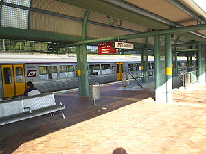
Station statistics
Address 11 Foxwell Road, Coomera
Coordinates 27°51′09″S 153°19′01″E / 27.8525°S 153.3169°E / -27.8525; 153.3169Coordinates: 27°51′09″S 153°19′01″E / 27.8525°S 153.3169°E / -27.8525; 153.3169
Lines
  Gold Coast Line
Platforms 2 total (1 island platform)
Other information
Accessible Handicapped/disabled access
Owned by Queensland Rail
Fare zone 10 (TransLink)
Services
Preceding station   Queensland Rail   Following station
toward Bowen Hills
Gold Coast Line
Helensvale
toward Varsity Lakes

Coomera is a railway station on the Gold Coast Line of South East Queensland, Australia. It is part of the Queensland Rail City network. Located 59.59 km from Central Station, Coomera is in Zone 10 of the TransLink integrated public transport system. It is the closest railway station to the major Gold Coast theme park Dreamworld.

Services by platform

Platform Line Destination Notes
1 Gold Coast Varsity Lakes All stations
2 Airport City & Brisbane Airport Limited stations Beenleigh to South Bank, then express Bowen Hills to Eagle Junction

See also

External links


Wikimedia Foundation. 2010.

Игры ⚽ Поможем написать курсовую

Look at other dictionaries:

  • Coomera railway station, Queensland — Citytrain Station station name=Coomera region=Gold Coast servicearea1=Gold Coast IB1=Ormeau OB1=Helensvale street=Foxwell Road suburb=Coomera zone=10 distance=59.59 platforms=2 platform arch=1 island access=Underpass trainconnect=No… …   Wikipedia

  • Ormeau railway station — Ormeau Station statistics Address 200 Mirambeena Drive, Pimpama Coordinates …   Wikipedia

  • Nerang railway station — Nerang Station statistics Address Warrener Street, Nerang …   Wikipedia

  • Helensvale railway station, Queensland — Citytrain Station station name=Helensvale region=Gold Coast servicearea1=Gold Coast IB1=Coomera OB1=Nerang street=Discovery Drive suburb=Helensvale zone=12 distance=68.26 platforms=2 platform arch=1 island access=Overpass trainconnect=No… …   Wikipedia

  • Coopers Plains railway station — Coopers Plains Station statistics Address Henley Street, Coopers Plains Coordinates …   Wikipedia

  • Ormeau railway station, Queensland — Citytrain Station station name=Ormeau region=Gold Coast servicearea1=Gold Coast IB1=Beenleigh OB1=Coomera street=Mirambeena Drive suburb=Ormeau zone=9 distance=52.72 platforms=2 platform arch=2 side access=Overpass trainconnect=No busconnect=Yes… …   Wikipedia

  • Gold Coast railway line, Queensland — SEQ Transit Lines line type = rail from = Brisbane central business district to = Robina name = Gold Coast Line line owner = QR Limited map colour = Gold line length = 85.35 stations number = 13 operator names = Citytrain fleet names = IMU… …   Wikipedia

  • List of South East Queensland railway stations — This is a list of the suburban and interurban railway stations of south east Queensland, Australia focused around Brisbane, the capital city of Queensland.These services are operated by QR Citytrain under TransLink.For detailed travel information …   Wikipedia

  • Pimpama, Queensland — Infobox Australian Place | type = suburb name = Pimpama city = Gold Coast state = Queensland caption = lga = Gold Coast City postcode = 4209 pop = area = est = 1860cite book |title=Stories of the Southside |last=Roberts |first=Beryl |authorlink=… …   Wikipedia

  • Nerang, Queensland — Nerang Gold Coast, Queensland The Nerang railway station …   Wikipedia

Share the article and excerpts

Direct link
Do a right-click on the link above
and select “Copy Link”