- Nippes, Cologne
-
This article is about the district of Cologne. For other uses, see Nippes (disambiguation).
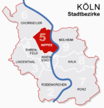
Nippes — 5th District of Cologne — Cologne-Weidenpesch Racecourse Location of Nippes shown in red Country Germany Federal state North Rhine-Westphalia City Cologne Area – Total 31.8 km2 (12.3 sq mi) Population (December 2008) – Total 110,092 – Density 3,462/km2 (8,966.5/sq mi) Nippes (German: Köln-Nippes) is the Fifth city district (Stadtbezirk) of Cologne, Germany. Nippes was merged into the city of Cologne in 1888, the district was formed in 1975. In Niehl, the North-eastern part of the district lies the large Ford Europe production plant.
The district borders with the Cologne districts of Chorweiler to the North, Mülheim to the East, Innenstadt to the South and Ehrenfeld to the South-West.
Contents
Transportation
Nippes is served by numerous railway stations and highway. Train station include Köln-Nippes, Köln Geldernstraße/Parkgürtel and Köln-Longerich, as well as numerous light rail stations of Cologne Stadtbahn line 12, 15, 16 and 18. The Bundesautobahn 57 connects Nippes with the Cologne Beltway.
Rhine bridges
Subdivisions
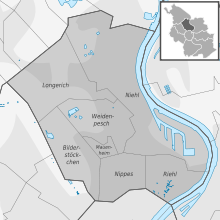
Nippes consists of seven Stadtteile (city parts):
# City part Population (2009) Area (km²) Pop. per km² map 501 Nippes 33,948 2,99 11,351 
502 Mauenheim 5,641 0,49 11,543 503 Riehl 11,173 2,39 4,674 504 Niehl 18,249 12,1 1,512 505 Weidenpesch 13,566 3,91 3,469 506 Longerich 13,536 6,14 2,203 507 Bilderstöckchen 15,028 3,76 3,992 source: Die Kölner Stadtteile in Zahlen 2010 (German) External links
- Official webpage of the district (German)
Districts of Cologne I. Innenstadt · II. Rodenkirchen · III. Lindenthal · IV. Ehrenfeld · V. Nippes · VI. Chorweiler · VII. Porz · VIII. Kalk · IX. Mülheim Categories:
- North Rhine-Westphalia geography stubs
- Boroughs and quarters of Cologne
- Nippes, Cologne
Wikimedia Foundation. 2010.


