- Coleman Municipal Airport
-
Coleman Municipal Airport 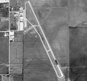
1994 USGS Photo IATA: COM – ICAO: KCOM Summary Airport type Public Owner City of Coleman Location Coleman, Texas Elevation AMSL 1,697 ft / 517 m Coordinates 31°50′28″N 099°24′12″W / 31.84111°N 99.40333°WCoordinates: 31°50′28″N 099°24′12″W / 31.84111°N 99.40333°W Runways Direction Length Surface ft m 15/33 4,503 1,373 Asphalt Coleman Municipal Airport (IATA: COM, ICAO: KCOM) is a public airport located approximately 2 miles (3.2 km) northeast of Coleman, Texas. It provides general aviation service.
Contents
History
Opened on 1 October 1941. Began training United States Army Air Corps flying cadets under contract to Coleman Flying School under 304th Flying Training Detachment. Assigned to United States Army Air Forces Gulf Coast Training Center (later Central Flying Training Command) as a primary (level 1) pilot training airfield. had four local axillary airfields for emergency and overflow landings. Flying training was performed with Fairchild PT-19s as the primary trainer. Also had several PT-17 Stearmans assigned.
Inactivated on 16 October 1944 with the drawdown of AAFTC's pilot training program. Declared surplus and turned over to the Army Corps of Engineers on 30 September 1945. Eventually discharged to the War Assets Administration (WAA) and became a civil airport.
See also
References
 This article incorporates public domain material from websites or documents of the Air Force Historical Research Agency.
- Shaw, Frederick J. (2004), Locating Air Force Base Sites History’s Legacy, Air Force History and Museums Program, United States Air Force, Washington DC, 2004.
- Manning, Thomas A. (2005), History of Air Education and Training Command, 1942–2002. Office of History and Research, Headquarters, AETC, Randolph AFB, Texas ASIN: B000NYX3PC
External links
- FAA Terminal Procedures for COM, effective 20 October 2011
- Resources for this airport:
- AirNav airport information for COM
- FlightAware airport information and live flight tracker
- SkyVector aeronautical chart for COM
 Army Air Forces Training Command
Flying Training Flying Schools Eastern Flying Training Command · Central Flying Training Command · Western Flying Training CommandSpecialized Schools Bombardier · Contract Flying · Glider Training · Gunnery · Navigator
Technical Training Eastern Technical Training Command · Central Technical Training Command · Western Technical Training CommandCategories:- 1941 establishments
- USAAF Contract Flying School Airfields
- Airfields of the United States Army Air Forces in Texas
- Buildings and structures in Coleman County, Texas
- Transportation in Coleman County, Texas


Wikimedia Foundation. 2010.