- Coixtlahuaca District, Oaxaca
-
Coixtlahuaca District — District — Oaxaca regions and districts: Mixteca to Northwest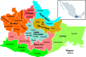
Coordinates: 17°43′N 97°19′W / 17.717°N 97.317°W Country  Mexico
State Oaxaca Area – Total 1,666 km2 (643.2 sq mi) Population (2005) – Total 9,018 Coixtlahuaca District is located in the northeast of the Mixteca Region of the State of Oaxaca, Mexico. As of 2005 the population was 9,018, down 2.8% from 2000.[1]
The region is generally from 2,000m to 3,000m high, mostly hilly or mountainous with small plains. Temperatures range from 3°C to 36°C. Much of the area has been deforested and rainfall has decreased in recent years, affecting production of the standard crops of corn, wheat, beans and barley. It is the traditional home of the Chocho people, although they are now a small minority. The population has been shrinking due to emigration for economic reasons.[2]
Municipalities
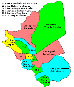 Coixtlahuaca municipalities
The district includes the following municipalities:[3]
- Concepción Buenavista,
- San Cristobal Suchixtlahuaca,
- San Francisco Teopan,
- San Juan Bautista Coixtlahuaca,
- San Mateo Tlapiltepec,
- San Miguel Tequixtepec,
- San Miguel Tulancingo,
- Santa Magdalena Jicotlán,
- Santa María Nativitas,
- Santiago Ihuitlán Plumas,
- Santiago Tepetlapa,
- Tepelmeme Villa de Morelos and
- Tlacotepec Plumas.
See also
References
- ^ "Distrito 03 Coixtlahuaca". Oeidrus Oaxaca. http://www.oeidrus-oaxaca.gob.mx/fichas/tomoI/distrito03.pdf. Retrieved 2010-07-08.
- ^ "Chochos o Chocholtecas". Go-Oaxaca. http://www.go-oaxaca.com/overview/chochos.html. Retrieved 2010-07-08.[dead link]
- ^ "Enciclopedia de los Municipios de México: Estado de Oaxaca". http://www.e-local.gob.mx/work/templates/enciclo/oaxaca/. Retrieved 2010-07-08.
Istmo Region Juchitán
TehuantepecCañada Region Papaloapan Region Sierra Norte Region Valles Centrales Region Sierra Sur Region Costa Region Jamiltepec
Juquila
PochutlaCoordinates: 17°43′N 97°19′W / 17.717°N 97.317°W
- Districts of Oaxaca
- Oaxaca geography stubs


Wikimedia Foundation. 2010.