Coffee Cove, Newfoundland and Labrador
- Coffee Cove, Newfoundland and Labrador
-
Categories:
- Populated places in Newfoundland and Labrador
- Newfoundland and Labrador geography stubs
Wikimedia Foundation.
2010.
Look at other dictionaries:
Lower Island Cove, Newfoundland and Labrador — Location map|Newfoundland width=220 lon dir=W|lat dir=N lat deg = 48 lat min = 00 lat sec = 02 lon deg = 52 lon min = 58 lon sec = 47 label = Lower Island Cove position = left caption = Map showing location of Lower Island CoveLower Island Cove… … Wikipedia
List of communities in Newfoundland and Labrador — This page lists communities of the province of Newfoundland and Labrador, Canada. Incorporated towns or cities are recognized as census subdivisions by Statistics Canada and can be found on List of cities and towns in Newfoundland and Labrador.… … Wikipedia
Baie Verte-Springdale — Infobox Canadian provincial riding name = Baie Verte province = Newfoundland and Labrador legislature = Newfoundland and Labrador House of Assembly member type = MHA party colour = Progressive Conservatives member = Kevin Pollard member party =… … Wikipedia
Plantation — For other uses, see Plantation (disambiguation). A pine plantation in the United States. Plantations are usually easily distinguished from natural forests by the trees being planted in straight lines. A plantation is a large artificially… … Wikipedia
The Irish Descendants — are a folk group from the Atlantic province of Newfoundland and Labrador, Canada. All the members, born of Irish emitters, were workers in the Newfoundland fishing industry before forming the band in 1990 out of the remnants of two former… … Wikipedia
Ochre — This article is about a color and its pigment. For other uses, see Ochre (disambiguation). Red ocher redirects here. For the indigenous people of North America, see Red Ocher people. Ochre Color coordinates … Wikipedia
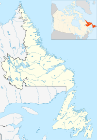
 Coffee CoveLocation of Coffee Cove in Newfoundland and Labrador