- Coeymans Creek
-
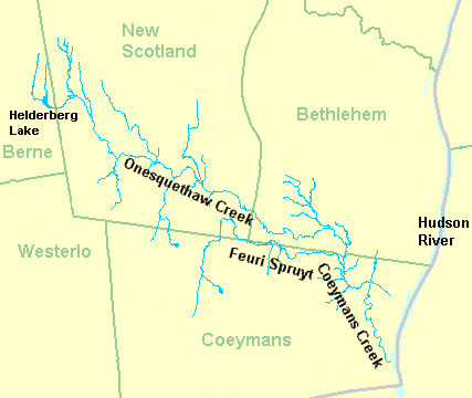
Coeymans Creek (O-nis-ke-thau) Onesquethaw Creek, Oniskethau Kil River Country United States State New York County Albany Towns Bethlehem, Coeymans Source - location Bethlehem, New York - coordinates 42°32′19″N 73°49′40″W / 42.53861°N 73.82778°W Mouth Hudson River - location Coeymans, New York - elevation 0 ft (0 m) - coordinates 42°28′34″N 73°47′23″W / 42.47611°N 73.78972°W 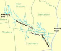 Onesquethaw and Coeymans Creeks
Coeymans Creek[1] is a 7.3-mile-long (11.7 km)[2] creek that runs though Albany County, New York. It is a tributary of the Hudson River. The creek originates as the continuation of Onesquethaw Creek,[3] which starts near Clarksville, New York, in the Helderberg Mountains.
Contents
History
O-nis'-ke-thau Creek is also called Coeymans Creek. There was a hamlet of this name in New Scotland as well as Oniskethau flats and mountain. It is said to have been an early Native American name meaning cornfields. [4]
Tributaries
- Mosher Brook
- Onesquethaw Creek
- Feuri Spruyt (Feuri-Sprayt Kill), a small stream in the north part of Coeymans, disappears, and flows for half a mile in a subterranean passage, coming to the surface again in New Scotland.
See also
References
- ^ 974198 U.S. Geological Survey Geographic Names Information System: Coeymans Creek
- ^ U.S. Geological Survey. National Hydrography Dataset high-resolution flowline data. The National Map, accessed October 3, 2011
- ^ 959382 U.S. Geological Survey Geographic Names Information System: Coeymans Creek
- ^ Aboriginal place names of New York, By William Martin Beauchamp, page 22
Categories:- Geography of Albany County, New York
- Rivers of New York
- Tributaries of the Hudson River
Wikimedia Foundation. 2010.