- Coconut Island (Hawaii Island)
-
For other uses, see Coconut Island (disambiguation).
Coconut Island N/A 
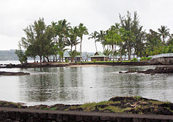
Bridge to island with palm trees-Moku OlaGeography Location 19°43′46″N 155°4′7″W / 19.72944°N 155.06861°WCoordinates: 19°43′46″N 155°4′7″W / 19.72944°N 155.06861°W Coconut Island, or Moku Ola is a small island in Hilo Bay, just offshore from Liliʻuokalani Gardens, in Hilo, off the island of Hawaiʻi in the state of Hawaii, USA. It is a small park, and is connected to the main island via a footbridge. The island includes a large grassy field, picnic areas, restroom facilities, and a few tiny sandy beaches.[1] The name Moku ola literally means "healing island" in the Hawaiian language, since it was site of an ancient temple dedicated to healing.[2] It is located off Banyan Drive at coordinates 19°43′46″N 155°4′7″W / 19.72944°N 155.06861°WCoordinates: 19°43′46″N 155°4′7″W / 19.72944°N 155.06861°W.[3]
References
- ^ "Letʻs Go Hawaii - Coconut Island, Hilo Hawaii". Letʻs Go Hawaii. 2009. http://www.letsgo-hawaii.com/coconutisland/. Retrieved 2010-01-20.
- ^ Lloyd J. Soehren. "lookup of mokuola". Hawaiian Place Names web site. University of Hawaii. http://ulukau.org/cgi-bin/hpn?e=q-0mahele--00-0-0--010---4----dtt--0-0l--1en-Zz-1---20-about-mokuola--00031-00010escapewin-00&a=d&c=mahele&cl=search&d=HASH01f6f34fd282d21d593797fb. Retrieved 2010-03-17.
- ^ U.S. Geological Survey Geographic Names Information System: Coconut Island
Categories:- Islands of Hawaii
- Landforms of Hawaii (island)
Wikimedia Foundation. 2010.
