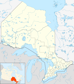
- Clute, Ontario
-
Clute — unincorporated community — Location within Ontario Coordinates: 49°11′22″N 81°4′24″W / 49.18944°N 81.07333°WCoordinates: 49°11′22″N 81°4′24″W / 49.18944°N 81.07333°W Country Canada Province Ontario District Cochrane Area name Cochrane, Unorganized, North Part Elevation 888 ft (271 m) Clute is an unincorporated community in Cochrane, Unorganized, North Part, Ontario, within the Territorial District of Cochrane, Ontario, Canada. It is also the name of a geographic township in Cochrane District[1] and the name of a stop served by the Polar Bear Express passenger train. The coordinates of the community are given by the Atlas of Canada as 49° 11' 22" North 81° 4' 24" West; of the township, 49° 7' 25" North 81° 10' 22" West.[2]
It is served by Highway 579.
References
- ^ "GeoNames Index: Clouston Rapids - Clyde Creek". OnTerm - Ontario Terminology. Ontario Ministry of Government Services. http://www.onterm.gov.on.ca/geo/details_e.asp?letter=c&ind=2551. Retrieved 2009-02-13.
- ^ "Clute". Atlas of Canada. http://atlas.nrcan.gc.ca/site/english/search/search_results?expression=Clute&image2.x=10&image2.y=9. Retrieved 2009-02-13.
Categories:- Communities in Cochrane District, Ontario
- Northern Ontario geography stubs
Wikimedia Foundation. 2010.

