- Hudnut, Indiana
-
Hudnut — Unincorporated town — Parke County's location in Indiana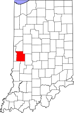 Location in Parke County
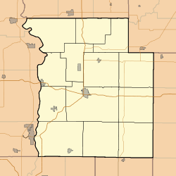
 Hudnut
Coordinates: 39°39′34″N 87°22′37″W / 39.65944°N 87.37694°WCoordinates: 39°39′34″N 87°22′37″W / 39.65944°N 87.37694°W Country  United States
State  Indiana
County Parke County Township Florida Township Elevation 151 m (495 ft) GNIS feature ID 436569[1] Hudnut, also known as Clinton Locks, is an unincorporated town in western Florida Township, Parke County, Indiana, USA, just east of Clinton, Indiana.
Geography
Hudnut is located at 39°39′34″N 87°22′37″W / 39.65944°N 87.37694°W at an elevation of 495 feet.
References
- ^ "Hudnut". Geographic Names Information System, U.S. Geological Survey. http://geonames.usgs.gov/pls/gnispublic/f?p=gnispq:3:::NO::P3_FID:0436569. Retrieved 2010-11-01.
Municipalities and communities of Parke County, Indiana Towns 
Townships Unincorporated
communitiesAlma Lake | Annapolis | Armiesburg | Bellmore | Bethany | Bradfield Corner | Bridgeton | Byron | Catlin | Coloma | Coxville | Diamond | Ferndale | Grange Corner | Guion | Hollandsburg | Howard | Hudnut | Jessup | Judson | Klondyke | Lena | Lodi | Lyford | Mansfield | Midway | Milligan | Minshall | Numa | Nyesville | Smockville | Snow Hill | Sylvania | Tangier | West Atherton | West Melcher | West Union
Categories:- Unincorporated communities in Indiana
- Populated places in Parke County, Indiana
- Indiana geography stubs


Wikimedia Foundation. 2010.