- Clanbrassil Street
-
Coordinates: 53°19′56″N 6°16′31″W / 53.33222°N 6.27528°W Clanbrassil Street (Irish: Sráid Chlann Breasaill) is a street in Dublin south of the city centre. It runs from Robert Emmet Bridge on the Grand Canal to New Street. It is served by several bus routes.[1]
 Leonard's Corner and Upper Clanbrassil Street, looking towards Robert Emmet Bridge
It is named after James Hamilton, 2nd Earl of Clanbrassil.[2]
Contents
History
 19th century houses on the east side of Lower Clanbrassil St.
From earliest times the street formed part of the Slige Chualann, which ran south from the settlement at Áth Cliath. It took its name from Cualu, the district in which Dublin was situated and which lay between the mouths of the Liffey and the Avoca (in County Wicklow).
In 1868, a new street was opened to connect Harold's Cross with Lower Clanbrassil Street. The Lord Mayor, the Aldermen and Frederick Stokes, who had purchased the land and led the project, attended the opening. The street was to be called Kingsland Street, but in fact, that name was never used, and it became Upper Clanbrassil Street.
Between 1886 and 1892, 128 houses were built off Clanbrassil St. (on Daniel St. and Harty Place) by the Dublin Artisans Dwelling Company for the industrial and working classes.[3]
Lower Clanbrassil St. was known as part of Little Jerusalem because in the first half of the Twentieth century it was at the heart of the Jewish community in Ireland. The first Jews fleeing conditions in Lithuania (then part of the Russian Empire) arrived in the early 1870s and eventually settled off Lower Clanbrassil St. In the following decades many of them settled along the South Circular Road, both sides of Leonard's Corner, and in the side-streets off it.[4]
Development of the new road
 Head shop, Upper Clanbrassil Street
In 1953 all residents of Clanbrassil St. received a notice from Dublin Corporation that residences on the west side of the street would have to have 16 feet (4.9 m) removed from the frontage of the properties to make way for a new road. This proposal was constantly changed or deferred, so that in the 1960s and 1970s the street fell into ruin. One by one businesses, public houses and retail outlets closed up or were demolished, and that side of the road became a wasteland. By 1980 the road engineers had increased the amount of space needed to 60 feet (18.3 m), in order to run a 6-lane dual carriageway through the street, past St. Patrick's Cathedral on to Christ Church Cathedral.[5]
After protests and demonstrations by locals and sympathisers against the road, and intervention by the Taoiseach, Charles Haughey, work on the road eventually began in 1989. A 4-lane dual carriageway was constructed, flanked by new houses and apartments. The cost of the road was estimated to be £2 million.
Among the areas destroyed by the road construction was the crossing known locally as the "Four Corners of Hell" (the junction of Patrick St., Dean St., New St. and Kevin St.), because there was a public house on each corner. Also the well-known hostelry the Bunch of Grapes (formerly Fitzpatrick's, constructed in 1739).[5]
Literary allusion
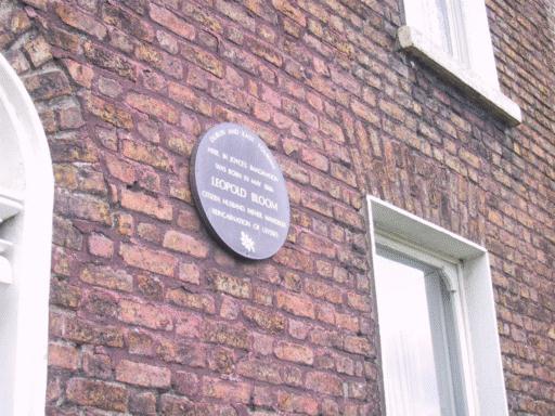
Leopold Bloom, the fictional Jewish character at the heart of the James Joyce novel Ulysses, lived at "52 Clanbrassil Street"; a plaque commemorating this can be found on the wall of 52 Upper Clanbrassil Street.
See also
References
- ^ Casey, Christine (2005). Dublin: The City Within the Grand and Royal Canals and the Circular Road with the Phoenix Park. Yale: Yale University Press. pp. p. 667. ISBN 0300109237.
- ^ Rev. C. T. M'Cready (last modified 1998). "Dublin Street Names Dated and Explained". 1892. http://www.chaptersofdublin.com/books/DublinSt/dubstreetp.htm. Retrieved 2008-10-06.
- ^ Clanbrassil Street, Past and Present history, Sean Lynch, Part 2
- ^ Keogh, Dermot (1998). Jews in Twentieth-century Ireland. Cork: Cork University Press. pp. 64–70. ISBN 9781859181508.
- ^ a b Clanbrassil Street, Past and Present history, Sean Lynch, Part 1
External links
Categories:- Streets in Dublin (city)
- History of Dublin (city)
- Geography of County Dublin


Wikimedia Foundation. 2010.