- Citadel Mountain
-
Citadel Mountain 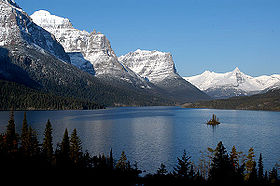
Citadel Mountain rises above Saint Mary Lake in the center of the picture in the distanceElevation 9,030 ft (2,752 m) [1] Prominence 2,150 ft (655 m) [2] Location Location Glacier County, Montana, USA Range Lewis Range Coordinates 48°37′56″N 113°39′18″W / 48.63222°N 113.655°WCoordinates: 48°37′56″N 113°39′18″W / 48.63222°N 113.655°W[3] Topo map USGS Logan Pass, MT Climbing First ascent 1939[2]  Little Chief Mountain, Blackfoot Mountain, and Citadel Mountain, viewed from Goat Mountain '
Citadel Mountain (9,030 feet (2,752 m)) is located in the Lewis Range, Glacier National Park in the U.S. state of Montana.[1][2] The mountain is located at the western edge of Saint Mary Lake and is easily seen from the Going-to-the-Sun Road.
See also
Cited references
- ^ a b "Citadel Mountain, Montana" (Map). My Topo (USGS Quads). http://www.mytopo.com/maps.cfm?search_string=Citadel+Mountain+montana. Retrieved 2010-03-07.
- ^ a b c "Citadel Mountain, Montana". Peakbagger.com. http://www.peakbagger.com/peak.aspx?pid=4798. Retrieved 2010-03-07.
- ^ "Citadel Mountain". Geographic Names Information System, U.S. Geological Survey. http://geonames.usgs.gov/pls/gnispublic/f?p=gnispq:3:::NO::P3_FID:769884. Retrieved 2010-09-26.
Categories:- Mountains of Glacier County, Montana
- Mountains of Glacier National Park (U.S.)
- Montana geography stubs

Wikimedia Foundation. 2010.