- Clarence E. Page Municipal Airport
-
Clarence E. Page Municipal Airport 
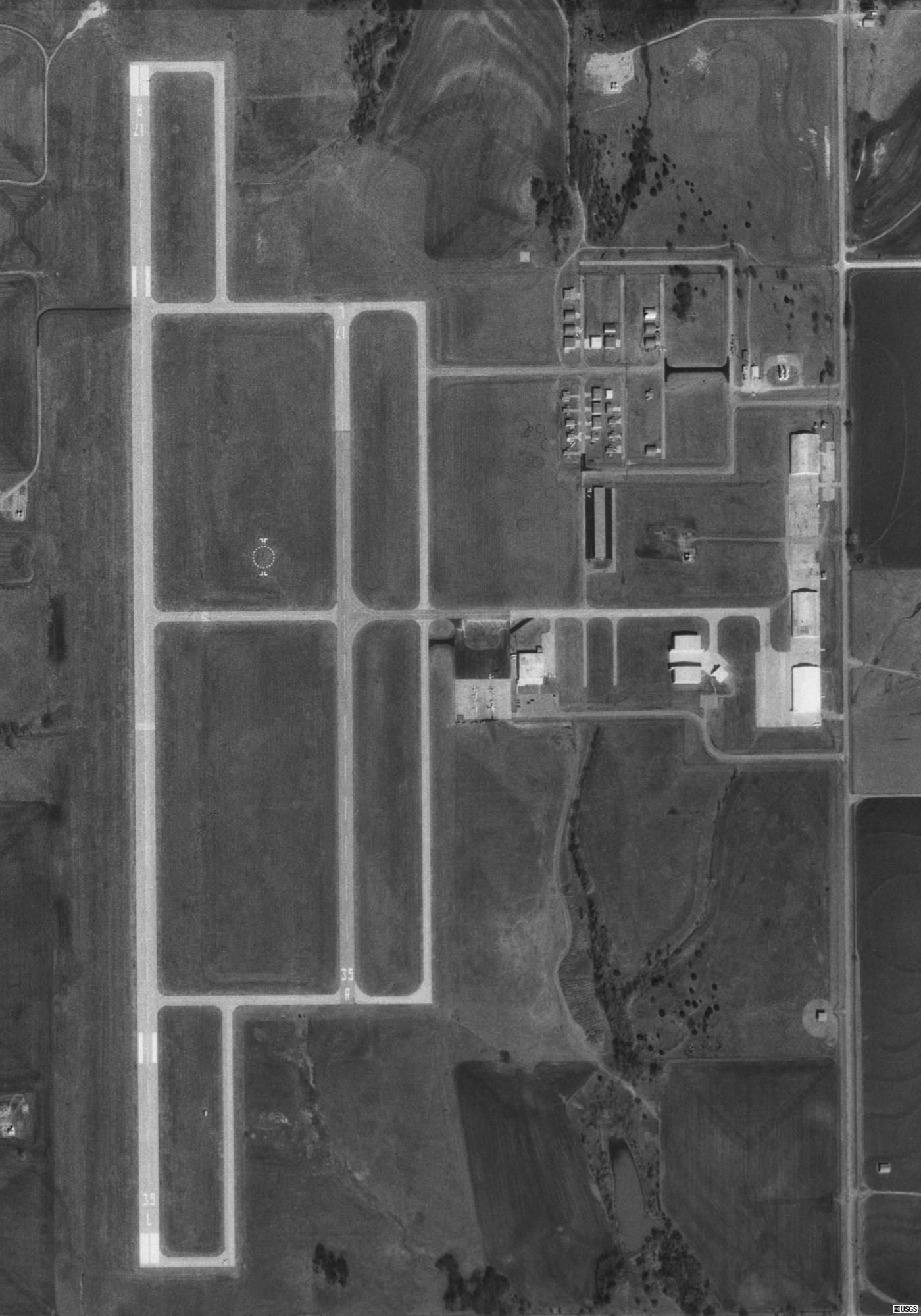
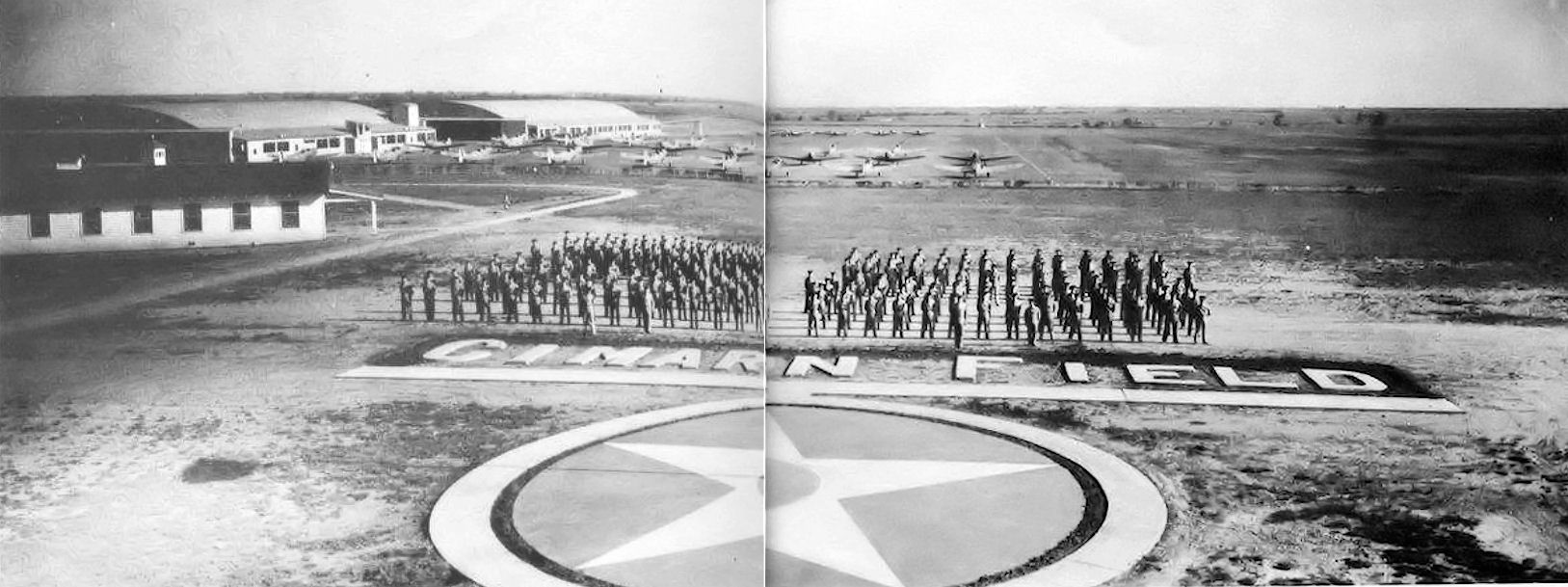
USGS aerial image - 19 February 1995 IATA: none – ICAO: KRCE – FAA LID: RCE Summary Airport type Public Owner City of Oklahoma City Serves Oklahoma City, Oklahoma Location Oklahoma City, Canadian County, Oklahoma, USA Elevation AMSL 1,354 ft / 413 m Coordinates 35°29′17″N 097°49′25″W / 35.48806°N 97.82361°W Runways Direction Length Surface ft m 17R/35L 6,014 1,833 Concrete 17L/35R 3,502 1,067 Concrete Statistics (2008) Aircraft operations 25,000 Based aircraft 52 Source: Federal Aviation Administration[1] 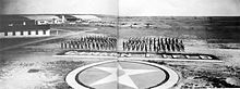 Photo of graduates of the Army Air Forces contract flight school at Cimarron Field, Oklahoma, 1944
Clarence E. Page Municipal Airport (ICAO: KRCE, FAA LID: RCE, formerly F29) is a city-owned public-use airport located in Canadian County, Oklahoma, United States. It is 15 nautical miles (28 km) west of the central business district of Oklahoma City, but still within its city limits.[1] This airport is included in the FAA's National Plan of Integrated Airport Systems (2009–2013), which categorizes it as a general aviation airport.[2]
Although most U.S. airports use the same three-letter location identifier for the FAA and IATA, this airport is assigned RCE by the FAA but has no designation from the IATA[3] (which assigned RCE to Roche Harbor, Washington[4][5]).
Contents
Facilities and aircraft
Clarence E. Page Municipal Airport covers an area of 1,000 acres (400 ha) at an elevation of 1,354 feet (413 m) above mean sea level. It has two runways with concrete surfaces: 17R/35L is 6,014 by 100 feet (1,833 x 30 m) and 17L/35R is 3,502 by 75 feet (1,067 x 23 m).[1]
For the 12-month period ending July 2, 2008, the airport had 25,000 aircraft operations, an average of 68 per day, all of which were general aviation. At that time there were 52 aircraft based at this airport: 73% single-engine, 2% multi-engine, 6% helicopter and 19% ultralight.[1]
History
Opened in October, 1941, the airport conducted contract basic flying training for the United States Army Air Forces. Known as Cimarron Field, the wartime airport had five grass runways, with the runways being changed at various times, with three auxiliary airfields used for emergency and overflow landings/takeoffs. The contractor was Oklahoma Air College, Inc. Flying training was performed with Fairchild PT-19s as the primary trainer. Also had several PT-17 Stearmans and a few P-40 Warhawks assigned.
Inactivated on 27 June 1944 with the drawdown of AAFTC's pilot training program. The airfield was turned over to civil control at the end of the war though the War Assets Administration (WAA).
See also
Other airports owned by Oklahoma City include:
- Will Rogers World Airport, served by seven major airlines, regional and charter airlines
- Wiley Post Airport, a corporate and business jet general aviation airport
- Oklahoma World War II Army Airfields
References
 This article incorporates public domain material from websites or documents of the Air Force Historical Research Agency.
- Shaw, Frederick J. (2004), Locating Air Force Base Sites History’s Legacy, Air Force History and Museums Program, United States Air Force, Washington DC, 2004.
- Manning, Thomas A. (2005), History of Air Education and Training Command, 1942–2002. Office of History and Research, Headquarters, AETC, Randolph AFB, Texas ASIN: B000NYX3PC
- ^ a b c d FAA Airport Master Record for RCE (Form 5010 PDF). Federal Aviation Administration. Effective 27 August 2009.
- ^ FAA National Plan of Integrated Airport Systems: 2009-2013. Federal Aviation Administration. Published 1 October 2008.
- ^ Oklahoma City, Oklahoma - Clarence E. Page Municipal Airport (ICAO: KRCE, FAA: RCE). Great Circle Mapper. Accessed 14 October 2009.
- ^ Roche Harbor, Washington (IATA: RCE, FAA: WA09). Great Circle Mapper. Accessed 14 October 2009.
- ^ Roche Harbor Airport, WA (IATA: RCE). Aviation Safety Network. Accessed 14 October 2009.
External links
- Clarence E. Page Municipal Airport at Oklahoma Aeronautics Commission website
- FAA Airport Diagram (PDF), effective 20 October 2011
- FAA Terminal Procedures for RCE, effective 20 October 2011
- Resources for this airport:
- AirNav airport information for RCE
- FlightAware airport information and live flight tracker
- SkyVector aeronautical chart for RCE
 Army Air Forces Training Command
Flying Training Flying Schools Eastern Flying Training Command · Central Flying Training Command · Western Flying Training CommandSpecialized Schools Bombardier · Contract Flying · Glider Training · Gunnery · Navigator
Technical Training Eastern Technical Training Command · Central Technical Training Command · Western Technical Training CommandCategories:- 1941 establishments
- USAAF Contract Flying School Airfields
- Airfields of the United States Army Air Forces in Oklahoma
- Airports in Oklahoma
- Buildings and structures in Canadian County, Oklahoma
- Transportation in Oklahoma City, Oklahoma

Wikimedia Foundation. 2010.