- Church of St Peter and St Paul, South Petherton
-
Church of St Peter and St Paul 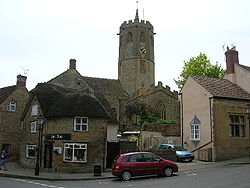
Location: South Petherton, Somerset, England Coordinates: 50°56′52″N 2°48′29″W / 50.94778°N 2.80806°WCoordinates: 50°56′52″N 2°48′29″W / 50.94778°N 2.80806°W Built: 13th century Listed Building – Grade I Designated: 19 April 1961[1] Reference #: 264257 
 Location of Church of St Peter and St Paul in Somerset
The Church of St Peter and St Paul in South Petherton, Somerset, England has Saxon origins. It retains a 13th century crosswing, with the remainder of the buildings dating from the 15th century, however it underwent major restorations in the late 19th and early 20th centuries. It has been designated as a grade I listed building.[1]
Contents
History and architecture
In its early history the church was connected to Bruton Abbey until the dissolution of the monasteries.[2]
The tower is an irregular octagon on plan, wider on its east-west axis, which is believed to be the tallest octagonal church tower in the United Kingdom.[3] It was erected in stages, the lower portion is from the 13th century with the upper stages added in the 15th.[2]
Interior
The church is home to several fine brass effigies. The effigies of Sir Giles Daubeney (d. 1445/46), and his first wife Joan. The effigies were engraved in around 1430.
Also in the South Chapel is a Ham stone effigy of an earlier member of the Daubeney family dating from no later than 1300. The effigy is of a man clad in mail and was found at Pitway, South Petherton on 7 March 1929.[4]
There is some stained glass but much of it was destroyed during the English Civil War.[2]
See also
- List of Grade I listed buildings in South Somerset
- List of towers in Somerset
References
- ^ a b "Church of St Peter and St Paul". Images of England. English Heritage. http://www.imagesofengland.org.uk/Details/Default.aspx?id=264257. Retrieved 2008-07-23.
- ^ a b c Robinson, W.J. (1915). West Country Churches. Bristol: Bristol Times and Mirror Ltd. pp. 197–201.
- ^ Vallins, John (2003-02-18). "Country Diary". The Guardian (The Guardian). http://www.guardian.co.uk/uk/2003/feb/18/ruralaffairs. Retrieved 2008-08-15.
- ^ "Chapter 1 - The Vagg Odyssey: A Thousand Years of the Vaggs'". http://web.ukonline.co.uk/mattb/odyssey01.html. Retrieved 2009-11-06.
External links
Categories:- Church of England churches in Somerset
- 13th-century architecture
- Grade I listed churches
- Grade I listed buildings in Somerset
- South Somerset


Wikimedia Foundation. 2010.