- Church of St Peter, Staple Fitzpaine
-
Church of St Peter 
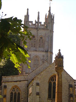
General information Town or city Staple Fitzpaine Country England Coordinates 50°57′32″N 3°02′59″W / 50.9588°N 3.0496°W Completed 14th century Church of St Peter, Staple Fitzpaine is Norman in origin, and has been designated as a Grade I listed building.[1]
The church has a Norman doorway reset in the south aisle. The chancel dates from the 14th century. The north aisle was added and the church refenestrated in the 15th century. The tower dates from about 1500, however the south porch and vestry are much more recent, dating from 1841. The crenellated three-stage tower has merlons pierced with trefoil headed arches set on a quatrefoil pierced parapet.
St Peter's has six bells. The oldest dates from 1480. There are four more original bells.[2] In 1803 one of the bells was made by Thomas Castleman Bilbie of Cullompton, one of the Bilbie family of bell founders and clock makers.[3] There is a long history of bell ringing, (campanology).
See also
- List of Grade I listed buildings in Taunton Deane
- List of towers in Somerset
References
- ^ "Church of St Peter". Images of England. http://www.imagesofengland.org.uk/details/default.aspx?id=271106. Retrieved 2007-09-29.
- ^ "Tower and Bells". Staple Fitzpaine Ringers. http://www.freewebs.com/staple_ringing/towerandbells.htm. Retrieved 2007-09-30.
- ^ Moore, James; Roy Rice and Ernest Hucker (1995). Bilbie and the Chew Valley clock makers. The authors. ISBN 0952670208.
Categories:- Church of England churches in Somerset
- 14th-century architecture
- Grade I listed churches
- Grade I listed buildings in Somerset
- Taunton Deane
Wikimedia Foundation. 2010.

