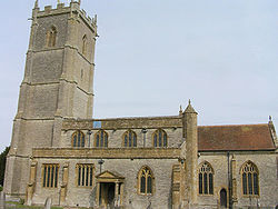
- Church of St Barnabas, Queen Camel
-
Church of St Barnabas Location: Queen Camel, Somerset, England Coordinates: 51°01′19″N 2°34′26″W / 51.02194°N 2.57389°WCoordinates: 51°01′19″N 2°34′26″W / 51.02194°N 2.57389°W Built: 14th century Listed Building – Grade I Designated: 24 March 1961[1] Reference #: 431093 The Church of St Barnabas in Queen Camel, Somerset, England was built in the 14th century and has been designated as a Grade I listed building.[1]
A former church in Queen Camel was the mother church to Somerton, Chilton Cantelo and the surrounding area before 1140. In the 12th century the church was given to Cleeve Abbey.[2] The first recorded rector was in 1317.[1] The church underwent Victorian restoration in 1888.[2]
The church has a 96 feet (29 m) high tower, built in five stages,[3] [1] which dates from around 1491,[4] The tower contains the heaviest peal of six bells in the world.[5][6]
The interior contains memorials to many of the Mildmay family,[1] who were Lords of the manor. There is a wooden rood screen and octagonal stone font supported by four large carved supports.[7]
The parish is part of the Cam Vale benefice, which includes Corton Denham, Sparkford, Sutton Montis, West Camel and Weston Bampfylde, within the Bruton and Cary deanery.[5]
See also
- List of Grade I listed buildings in South Somerset
- List of towers in Somerset
References
- ^ a b c d e "Church of St Barnabas". Images of England. English Heritage. http://www.imagesofengland.org.uk/Details/Default.aspx?id=431093. Retrieved 7 June 2009.
- ^ a b "Religious History". Victoria County History. http://www.victoriacountyhistory.ac.uk/sites/default/files/work-in-progress/queen_camel_religious_history.pdf. Retrieved 5 November 2011.
- ^ "Church History". Queen Camel Village. http://www.queen-camel.co.uk/churchhistory.html. Retrieved 5 November 2011.
- ^ Poyntz Wright, Peter (1981). The Parish Church Towers of Somerset, Their construction, craftsmanship and chronology 1350 - 1550. Avebury Publishing Company. ISBN 0861275020.
- ^ a b "St Barnabas, Queen Camel". Church of England. http://www.achurchnearyou.com/queen-camel-st-barnabas/. Retrieved 5 November 2011.
- ^ "St Barnabas — The Clock and Bells". Queen Camel Parish Council. http://www.queen-camel.co.uk/churchclock.html. Retrieved 5 November 2011.
- ^ "Queen Camel, St. Barnabas". English Church Arhcitecture. http://english-church-architecture.net/somerset/queen%20camel/queen_camel.htm. Retrieved 5 November 2011.
Categories:- Church of England churches in Somerset
- 14th-century architecture
- Grade I listed churches
- Grade I listed buildings in Somerset
- South Somerset
Wikimedia Foundation. 2010.


