- Chornobay Raion
-
Chornobay Raion — Raion — 
Flag
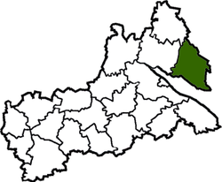
Coat of armsRaion location in Cherkasy Oblast Country  Ukraine
Oblast Cherkasy Oblast Admin. center Chornobai Area - Total 1,554 km2 (600 sq mi) Population (2011) - Total 43,108 Time zone EET (UTC+2) - Summer (DST) EEST (UTC+3) Chornobay Raion (Ukrainian: Чорнобаївський район) is a raion (district) of Cherkasy Oblast, central Ukraine. Its administrative centre is located at Chornobai. The raion covers an area of 1554 square kilometres and as of 2011 it had a population of 43,108 people.
Administrative divisions of Cherkasy Oblast, Ukraine Administrative center: Cherkasy Raions Cherkasy · Chornobay · Chyhyryn · Drabiv · Horodyshche · Kamyanka · Kaniv · Katerynopil · Khrystynivka · Korsun-Shevchenkivskyi · Lysianka · Mankivka · Monastyryshche · Shpola · Smila · Talne · Uman · Zhashkiv · Zolotonosha · Zvenyhorodka

Cities Cherkasy · Chyhyryn · Horodysche · Kamianka · Kaniv · Khrystynivka · Korsun-Shevchenkivskyi · Monastyrysche · Shpola · Smila · Talne · Uman · Vatutine · Zhashkiv · Zolotonosha · ZvenyhorodkaUrban-type
settlementsVillages Categories:- Geography articles needing translation from Ukrainian Wikipedia
- Ukraine geography stubs
- Raions of Cherkasy Oblast
Wikimedia Foundation. 2010.

