- Villages of Portland
-
For Portland as a single community, see Isle of Portland
The Isle of Portland, Dorset, contains eight settlements, the largest being Fortuneswell in Underhill and Easton in Tophill. Castletown and Chiswell are the other villages in Underhill, and Weston, Southwell, Wakeham and the Grove occupy Tophill.
Contents
Villages
Southwell
Southwell (pronounced south-well) 50°32′N 2°27′W / 50.533°N 2.45°W is a small coastal village in Tophill on the Isle of Portland, Dorset, between Portland Bill and the village of Easton. Unlike many of the other villages on Portland, Southwell has no commercial industry (discounting Southwell Business Park). The village has one Primary School, Southwell County Primary School.
Easton
Easton 50°33′N 2°26′W / 50.55°N 2.433°W is the second largest of eight villages on the Isle of Portland in Dorset, England. The village is situated on the top of the island or Tophill, in the English Channel, and was where the Easton Massacre took place. The village has a small square with many shops and shopping arcade, a Secondary school, four churches, a small park, and other amenities. Easton is also the location of Portland Young Offenders Institution. At the south end of Easton is Portland Museum.
Along with Fortuneswell, Easton is the main hub of the Isle of Portland's activities.
Fortuneswell
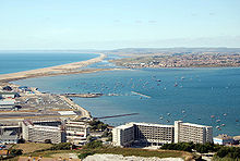
Fortuneswell and Portland Harbour, seen from The Verne. The Weymouth and Portland National Sailing Academy is on the left.
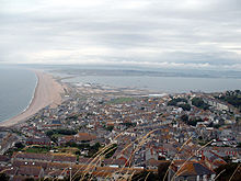
Fortuneswell is the largest of eight villages on the Isle of Portland, just off the coast of Dorset in the English Channel. The village lies on steeply sloping land on the northern edge of the island (Underhill), where Chesil Beach, the tombolo which connects the island to the mainland, joins the island.
The village has a main shopping street with several shops. The nearby villages of Chiswell and Castletown almost merge into Fortuneswell, as they share the limited space on the northern slopes of the island. However, Fortuneswell occupies the steepest land far above sea level, whereas Castletown and Chiswell occupy flat land close to sea level, next to Portland Harbour and Chesil Beach respectively.
Weston
50°32′22.96″N 2°26′50.24″W / 50.5397111°N 2.4472889°W Weston is a village in Tophill on the Isle of Portland, Dorset, England. It is on the outskirts of the main village Easton, and near also to the village of Southwell. Weston contains a Roman Villa - one of the few archaeological sites on the Isle of Portland, which is opposite the Royal Manor Arts College.
Castletown
Castletown is a small village in Underhill on the Isle of Portland in Dorset. It has a sandy beach and has a working port, Portland Port. The village itself is on the shores of Portland Harbour, and includes Portland Castle and the Weymouth and Portland National Sailing Academy. The village has a long naval history, and the Royal Navy had a base in the harbour until 1999. Now Portland Port is commercial, whilst still servicing and berthing Royal Fleet Auxiliary ships.
Chiswell
Chiswell (pronounced Chesil, Chis-well, or Chisel, rarely Chesilton) is a small fishing village at the southern end of Chesil Beach, in Underhill. The small bay at Chiswell is called Chesil Cove.
The village itself is indistinguishable from Fortuneswell, the largest village on the island, as the two settlements are very close. However this distinction can be made: Chiswell occupies flat land close to sea level, whereas Fortuneswell's streets wind up and down the steep hills.
Over the centuries Chiswell has battled with the sea and has been regularly flooded during rough winter storms which can over top the 15 metres (49 ft) high Chesil Beach which protects the village. Flood defences installed during the 1980s have alleviated the problems and there has not been widescale flooding since.[citation needed]
Wakeham
Wakeham is a small village near the village of Easton, in Tophill on the Isle of Portland in Dorset, England.
The Grove
The Grove is a small village near Easton containing the Youth Offender's Institute.
External links
 Media related to Villages of Portland at Wikimedia CommonsCategories:
- Villages in Dorset
- Isle of Portland
Wikimedia Foundation. 2010.


