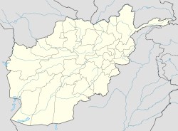
- Chiras, Afghanistan
-
Chiras — Village — Location in Afghanistan Coordinates: 35°25′N 65°59′E / 35.417°N 65.983°ECoordinates: 35°25′N 65°59′E / 35.417°N 65.983°E Country  Afghanistan
Province Sar-e Pol Province District Time zone + 4.30 Chiras is a major village and valley in Sar-e Pol Province, in northern Afghanistan. It was formerly in Jowzjan Province.[1]The village lies north of Jawak, west of Zabrak and southeast of Khami Deh. The people of Chiras are said to be Murghabi Tajiks.[2] The main occupation is agriculture, with most of the fertile lands lying to the west of the village and a narrow strip to the south.
In December 1883, Chiras was the subject of a confrontation between Maimana troops and Dilawar Khan.[3]Khan was forced to abandon Chiras.
References
- ^ Geographic Names, National Geospatial-Intelligence Agency, accessed 28 April, 2011
- ^ India. Army. General Staff Branch (1979). Historical and political gazetteer of Afghanistan. Akadem. Druck- u. Verlagsanst.. ISBN 9783201010894. http://books.google.com/books?id=1OrFAAAAIAAJ. Retrieved 29 April 2011.
- ^ Lee, Jonathan L. (1996). The "ancient supremacy": Bukhara, Afghanistan, and the battle for Balkh, 1731-1901. BRILL. p. 441. ISBN 9789004103993. http://books.google.com/books?id=nYaamE_3kD4C&pg=PA441. Retrieved 29 April 2011.
Categories:- Populated places in Sar-e Pol Province
- Valleys of Afghanistan
- Afghanistan geography stubs
Wikimedia Foundation. 2010.

