- Chiaravalle (district of Milan)
-
Chiaravalle — Quartiere of Milan — Chiaravalle Abbey
Country  Italy
ItalyRegion Lombardy Province Milan Comune Milan Zone 5 Time zone CET (UTC+1) - Summer (DST) CEST (UTC+2) Chiaravalle (Ceravall in Lombard) is a district ("quartiere") of Milan, Italy, part of the Zone 5 administrative division of the city. It is located in the periphery south of the city centre, within the Parco Agricolo Sud Milano nature reserve.
Before 1923, Chiaravalle was an autonomous comune, named Chiaravalle Milanese.
Despite being annexed to Milan, Chiaravalle has maintained the character of an autonomous town. The park that embraces the district also separates it from the urban agglomeration of the city. This isolation is reinforced by the scarceness of public transportation to the centre, which mostly consists of a single bus line connecting Chiaravalle to Porta Romana. As this bus line has a stop at the Milan Metro station of Corvetto, this is the subway station that actually serves Chiaravalle, despite that of Rogoredo being actually closer.
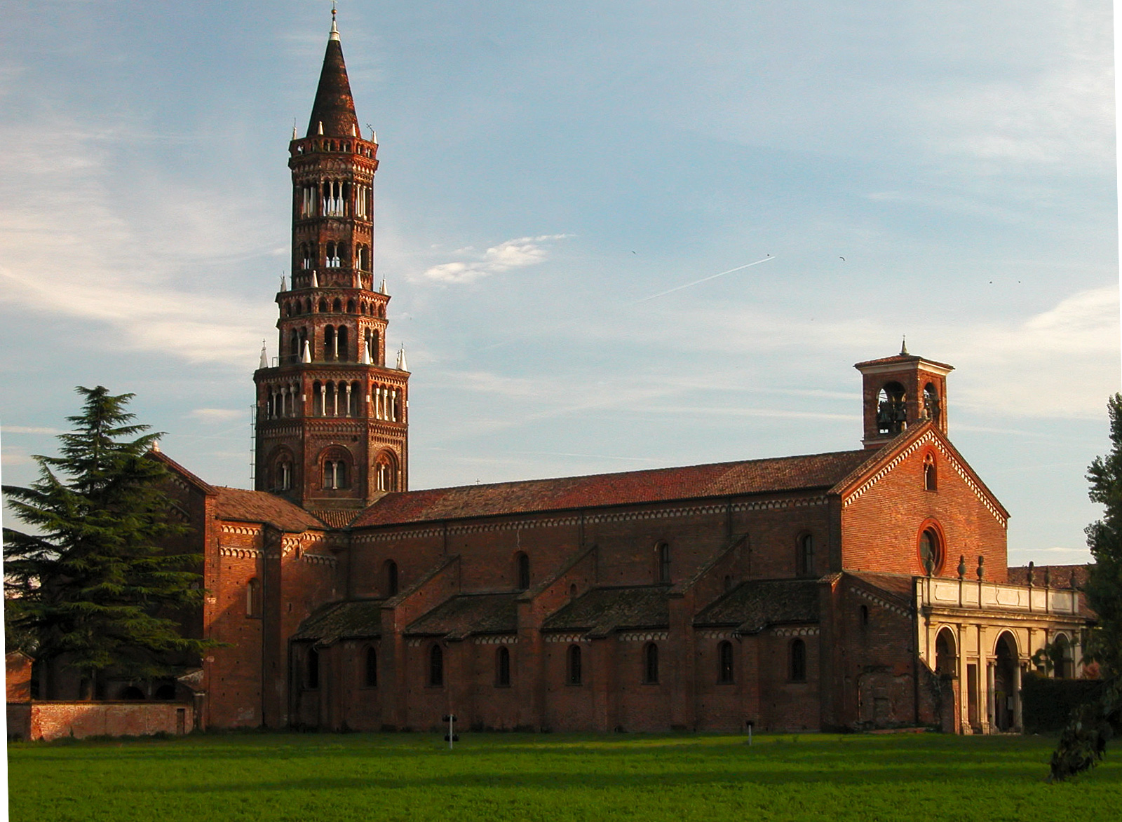
The main landmark of the Chiaravalle district is eponymous abbey, a Gothic-Romanesque 12th century monastic complex.
History
The original settlement of Chiaravalle formed in the middle ages, and was centered in the Chiaravalle Abbey founded by the Cistercians in 1135. When the Milanese territory was organized in pieves, Chiaravalle became part of Pieve di San Donato.
Under Napoleonic rule it was annexed to Milan, but went back to its autonomous status at the foundation of the Kingdom of Lombardy-Venetia. In 1861, Chiaravalle had 1,417 inhabitants.
In 1870 Chiaravalle and the nearby comune of Nosedo were merged.
In 1923, Chiaravalle became part of Milan.
External links
 Administrative divisions of Milan
 Zone 1 Brera • Centro Storico • Conca del Naviglio • Guastalla • Porta Sempione • Porta TenagliaZone 2 Adriano • Crescenzago • Gorla • Greco • Loreto • Maggiolina • Mandello • Mirabello • Ponte Seveso • Porta Nuova • Precotto • Stazione Centrale • Turro • Villaggio dei GiornalistiZone 3 Casoretto • Cimiano • Città Studi • Dosso • Lambrate • Ortica • Porta Monforte • Porta Venezia • Quartiere Feltre • RottoleZone 4 Acquabella • Calvairate • Castagnedo • Cavriano • Forlanini • Gamboloita • La Trecca • Monluè • Morsenchio • Nosedo • Omero • Ponte Lambro • Porta Vittoria • Porta Romana • Rogoredo • San Luigi • Santa Giulia • Taliedo • Triulzo SuperioreZone 5 Basmetto • Cantalupa • Case Nuove • Chiaravalle • Chiesa Rossa • Conca Fallata • Fatima • Gratosoglio • Le Terrazze • Macconago • Missaglia • Morivione • Porta Lodovica • Porta Vigentina • Quintosole • Ronchetto delle Rane • San Gottardo • Selvanesco • Stadera • Torretta • Vaiano Valle • VigentinoZone 6 Arzaga • Barona • Boffalora • Cascina Bianca • Conchetta • Creta • Foppette • Giambellino-Lorenteggio • Lodovico il Moro • Moncucco • Porta Genova • Porta Ticinese • Ronchetto sul Naviglio • San Cristoforo • Sant'Ambrogio • Teramo • Villa Magentino • Villaggio dei FioriZone 7 Assiano • Baggio • Figino • Fopponino • Forze Armate • Harar • La Maddalena • Muggiano • Porta Magenta • Quartiere degli Olmi • Quarto Cagnino • Quinto Romano • San Siro • Valsesia • VercelleseZone 8 Boldinasco • Bullona • Cagnola • Campo dei Fiori • Cascina Triulza • Comina • Fiera • Gallaratese • Garegnano • Ghisolfa • Lampugnano • Musocco • Porta Volta • Portello • Quarto Oggiaro • QT8 • Roserio • San Leonardo • Trenno • Varesina • Vialba • VillapizzoneZone 9 Affori • Bicocca • Bovisa • Bovisasca • Bruzzano • Ca' Granda • Centro Direzionale • Comasina • Dergano • Fulvio Testi • Isola • La Fontana • Montalbino • Niguarda • Porta Garibaldi • Porta Nuova • Prato Centenaro • SegnanoCategories:- Districts of Milan
- Former municipalities of Lombardy
- Province of Milan geography stubs
Wikimedia Foundation. 2010.