- Chelsea Harbour Pier
-
 London River Services
Chelsea Harbour Pier 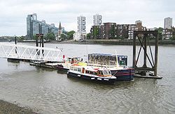
Chelsea Harbour Pier on the ThamesLocale River Thames, London, UK Transit type River bus and tourist/leisure services Owner London River Services Operator London River Services/Thames Executive Charters London River Services - City Cruises
- London Eye
- Bateaux London
- Crown River Cruises
- Lower Thames & Medway
- Woolwich Ferry
- Thames Clipper
- Thames Executive Charters
- Thames River Services
- Turks Launches
- Westminster Passenger Services
- Waverley Excursions
Chelsea Harbour Pier is a pier on the River Thames, in London, United Kingdom. It is located on the North Bank of the Thames, in the Sands End area of Chelsea. The pier serves the redeveloped Chelsea Harbour, a former commercial wharf which has been converted to luxury residential use.
Services
The pier is served by boats operated by Thames Executive Charters, under licence from London River Services. Services operate between Putney Pier and Blackfriars Millennium Pier in central London.[1]
Interchange
The pier is located approximately 200 metres from Imperial Wharf railway station on the West London Line. Rail services provided London Overground and Southern offer direct connections to stations in central London and beyond.
Preceding station London River Services Following station Wandsworth Riverside Quarter Piertoward PutneyPutney to Blackfriars Service Cadogan Piertoward Blackfriars Millennium PierReferences
- ^ "Boats from Chelsea Harbour Pier". Transport for London. Spring 2009. http://www.tfl.gov.uk/assets/downloads/chelsea-pier-route-map.pdf. Retrieved 2009-09-29.
Coordinates: 51°28′31″N 0°10′58″W / 51.47517°N 0.18281°W
Categories:- London River Services
- Transport in Kensington and Chelsea
- London Transport stubs

Wikimedia Foundation. 2010.