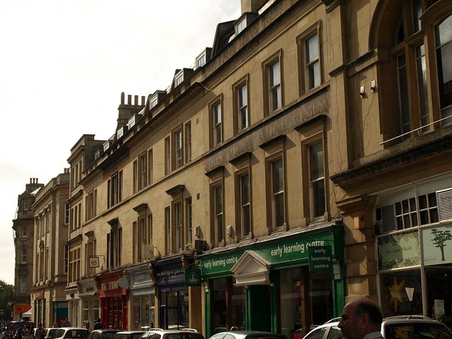
Cheap Street, Bath

Cheap Street, Bath
Cheap Street
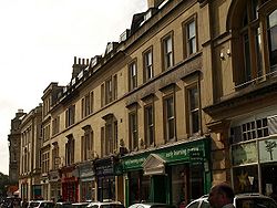
Location: Bath, Somerset, England
Coordinates: 51°22′56″N 2°21′36″W / 51.38222°N 2.36°W / 51.38222; -2.36Coordinates: 51°22′56″N 2°21′36″W / 51.38222°N 2.36°W / 51.38222; -2.36
Listed Building – Grade I
Official name: Number 14
Designated: 12 June, 1950[1]
Reference #: 442424
Listed Building – Grade II*
Official name: Number 13
Designated: 12 June, 1950[2]
Reference #: 442423
Listed Building – Grade II
Designated: 12 June, 1950
Reference #: 442425
Listed Building – Grade II
Official name: Number 21 and The Roundhouse
Designated: 11 August, 1972[3]
Reference #: 442426
Cheap Street, Bath is located in Somerset
{{{alt}}}
Location of Cheap Street in Somerset

Cheap Street in Bath, Somerset, England is adjacent to Bath Abbey and contains several listed buildings.

The road was known as Souter Street (meaning Shoemakers Street) until 1398.[4]

Number 13 which adjoins the abbey and is Grade II* listed.[2]

Number 14 was built around 1720. The central doorway is flanked on either side by pairs of windows with elliptical arches and Doric pilasters. There are also four Ionic pilasters and a central pediment on the 1st floor above the doorway and four Corinthian pilasters on the floor above that. It is adjacent to Marshal Wade's House in the Abbey Church Yard, and has been designated as a Grade I listed building.[1]

Number 15 to 19 were built as a block, including shop fronts divided by Doric columns, by Thomas Baldwin around 1789.[5]

Number 21 and The Roundhouse, which used to be known as the Abbey Wine Vaults, is a mid to late 19th century radiused round corner of Cheap Street and Stall Street.[3]

See also

  • List of Grade I listed buildings in Bath and North East Somerset

References

  1. ^ a b "Number 14". Images of England. English Heritage. http://www.imagesofengland.org.uk/Details/Default.aspx?id=442424. Retrieved 2009-08-29. 
  2. ^ a b "Number 13". Images of England. English Heritage. http://www.imagesofengland.org.uk/Details/Default.aspx?id=442423. Retrieved 2009-08-29. 
  3. ^ a b "Number 21 and The Roundhouse". Images of England. English Heritage. http://www.imagesofengland.org.uk/Details/Default.aspx?id=442426. Retrieved 2009-08-29. 
  4. ^ Wroughton, John (2006). Tudor Bath: Life and strife in the little city, 1485-1603. Bath: Lansdown Press. pp. 5. ISBN 0952024969. 
  5. ^ "Numbers 15 to 19". Images of England. English Heritage. http://www.imagesofengland.org.uk/Details/Default.aspx?id=442425. Retrieved 2009-08-29. 

Wikimedia Foundation. 2010.

Игры ⚽ Нужно решить контрольную?

Look at other dictionaries:

  • Cheap Repository Tracts — The Shepherd of Salisbury Plain, one of the most popular tracts The Cheap Repository Tracts was a series of around 120 political and religious tracts published between March 1795 and December 1797, for sale or distribution to literate poor people …   Wikipedia

  • Queen Victoria Street.- —    West from the Mansion House to Blackfriars Bridge (P.O. Directory). In Cheap, Cordwainer, Bread Street, Queenhithe, Castle Baynard, and Far ringdon Within Wards.    Construction recommended 1861 and provided for in Metropolitan Improvement Act …   Dictionary of London

  • Frome — For other uses, see Frome (disambiguation). Coordinates: 51°13′40″N 2°19′17″W / 51.2279°N 2.3215°W / 51.2279; 2.3215 …   Wikipedia

  • Thomas Baldwin (architect) — Thomas Baldwin (c.1750 ndash; 7 March 1820) was an English surveyor and architect in Bath.He did not originally hail from Bath but was first recorded in the city in 1774, where he was initially a clerk (later builder and assistant) to plumber,… …   Wikipedia

  • List of Grade I listed buildings in Somerset — There are over 6000 Grade I listed buildings in England. This page is a list of these buildings in the county of Somerset.Bath North East Somerset* Abbey Church, Bath (Grade A) * Abbey Church Yard, Bath: No 14 * Grand Pump Room, Bath * Grand Pump …   Wikipedia

  • Frome, Somerset — infobox UK place country = England latitude= 51.2279 longitude= 2.3215 official name= Frome population = 20440cite web|url=http://www.somerset.gov.uk/somerset/statistics/contents/population/estimates/2002mye/mendip.pdf|title=Population estimates… …   Wikipedia

  • Down the Road (Van Morrison album) — Down the Road Studio album by Van Morrison Released May 14, 2002 Recorded …   Wikipedia

  • India — /in dee euh/, n. 1. Hindi, Bharat. a republic in S Asia: a union comprising 25 states and 7 union territories; formerly a British colony; gained independence Aug. 15, 1947; became a republic within the Commonwealth of Nations Jan. 26, 1950.… …   Universalium

  • United Kingdom — a kingdom in NW Europe, consisting of Great Britain and Northern Ireland: formerly comprising Great Britain and Ireland 1801 1922. 58,610,182; 94,242 sq. mi. (244,100 sq. km). Cap.: London. Abbr.: U.K. Official name, United Kingdom of Great… …   Universalium

  • Business and Industry Review — ▪ 1999 Introduction Overview        Annual Average Rates of Growth of Manufacturing Output, 1980 97, Table Pattern of Output, 1994 97, Table Index Numbers of Production, Employment, and Productivity in Manufacturing Industries, Table (For Annual… …   Universalium

Share the article and excerpts

Direct link
Do a right-click on the link above
and select “Copy Link”