- Charlton-King-Vandam Historic District
-
Charlton-King-Vandam
Historic District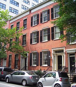 Federal style row houses at #35 (right) and #37 Charlton Street (c.1820)

Location: roughly bounded by King, Varick, Vandam, MacDougal & Houston Sts. and Sixth Ave.
Manhattan, New York CityCoordinates: 40°43′39″N 74°00′15″W / 40.7275°N 74.00417°WCoordinates: 40°43′39″N 74°00′15″W / 40.7275°N 74.00417°W Built: c.1820s-1840s Architectural style: Federal, Greek Revival, others Governing body: local NRHP Reference#: 73001215 Significant dates Added to NRHP: July 20, 1973[2] Designated NYCL: August 16, 1966[1] 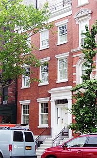 A Greek Revival townhouse c.1840 at 20 King Street
The Charlton-King-Vandam Historic District is a small historic district located in the South Village area of the Greenwich Village neighborhood of Manhattan, New York City. Designated by the New York City Landmarks Preservation Commission (NYCLPC) in 1966, the district contains "the city's largest concentration of row houses in the Federal style, as well as a significant concentration of Greek Revival houses."[3]
The district includes parts, but not all, of Charlton, King and Vandam Streets between the Avenue of the Americas (Sixth Avenue) and Varick Street (the southern extension of Seventh Avenue), as well as the block bounded by King, MacDougal and Houston Streets and Sixth Avenue.[4] In its designation report, the NYCLPC emphasized that this area was not a modern creation, but had "always been, since its beginning, a distinct and separate neighborhood."[1]
In 1973, the district was added to the National Register of Historic Places.[2]
Contents
History
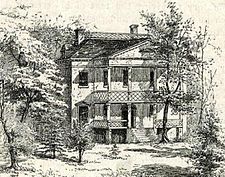 The Richmond Hill mansion
The Charlton-King-Vandam area was part of the estate of "Richmond Hill", a Georgian mansion built in 1767 and said to be one of the most beautiful mansions in Manhattan.[1] It was used by George Washington during the American Revolution as a headquarters and later became John Adams' Vice Presidential Mansion when the new country's capital was New York City. Aaron Burr bought the mansion, and after living in it for a time and using it as the site of lavish parties, it was Burr who, in 1797, mapped the property, dividing it into lots and laying out the grid of three streets, which would become Charlton, King and Vandam.[1] After Burr's duel with Alexander Hamilton, he lost control of the estate to John Jacob Astor, the leading land developer of the time, who paid off Burr in 1817 and proceeded to develop the area.[1]
Astor had the mansion moved from the top of the hill it stood on to the corner of Charlton and Varick, and the hill was levelled; the mansion was subsequently used as a theatre. Builders bought the majority of the lots Astor laid out, so that much of the construction in the neigborhood took place in the early and mid-1820s, although some Greek Revival houses date from the 1840s, replacing houses destroyed by fire.[1]
Architecture
The north sides of Charlton and Vandam Streets display "exceptional examples"[3] of Federal-style architecture, especially #37 and #39 Charlton Street,[5] as well as houses showing elements transitional to the early Greek Revival style.[1] King Street has a more varied mix, including Greek Revival houses, particularly those at #20 and #40-44,[5] and houses in the Federal, Anglo-Italianate and Roman Revival styles.[1] King also includes the former Public School 8, now converted to residences, designed by David Skagg and built in 1886,[5] which has been characterized as a "lively Queen Anne-style building".[3].
See also
- Richmond Hill (Manhattan)
- MacDougal-Sullivan Gardens Historic District
- South Village
References
- Notes
- ^ a b c d e f g h "Charlton - King - Vandam Designation Report" New York City Landmarks Preservation Commission (August 16, 1966)
- ^ a b NRHP database entry
- ^ a b c New York City Landmarks Preservation Commission. Guide to New York City Landmarks (4th ed.) New York:Wiley, 2009. ISBN 978-0-470-28963-1, p.41
- ^ NYCLPC Charlton-King-Vandam map
- ^ a b c White, Norval & Willensky, Elliot (2000). AIA Guide to New York City (4th ed.). New York: Three Rivers Press. ISBN 0812931076., pp. 154-155
External links
 Media related to Charlton-King-Vandam Historic District at Wikimedia Commons
See also: National Register of Historic Places listings in New York and List of National Historic Landmarks in New York Categories:- Historic districts in New York City


Wikimedia Foundation. 2010.