- 1925 Charlevoix–Kamouraska earthquake
-
1925 Charlevoix–Kamouraska earthquake 
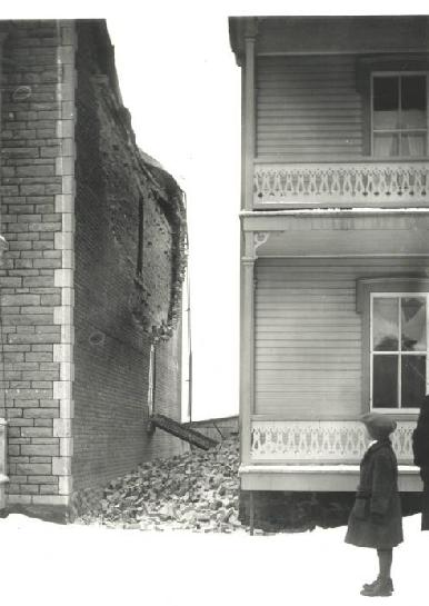
Damage in Shawinigan, QuebecDate February 28, 1925 Magnitude 6.2 Mw Depth 10 km (6 mi) Epicenter 47°48′N 69°48′W / 47.8°N 69.8°W Countries or regions  Canada
Max. intensity VIII - Destructive Tsunami none Aftershocks 55 The 1925 Charlevoix–Kamouraska earthquake was a major earthquake that struck the entire northeastern part of North America on February 2, 1925, reaching 6.2 on the moment magnitude scale.[1]
The earthquake was one of the most powerful measured in Canada in the 20th century.[1] The main shock epicentre occurred in the area of Charlevoix-Kamouraska, along the Saint Lawrence River, near île aux Lièvres. It was felt in Quebec, Shawinigan, Montreal, and as far south as Virginia, and as far west as the Mississippi River.[2] It caused damage in three separate areas. The first had extreme damage constricted to a narrow belt 20 miles long on both shores of the Saint Lawrence River near the epicentre.[3] In this area, damage at the villages of Baie-Saint-Paul, Saint-Urbain, Les Éboulements, Pointe-au-Pic, La Malbaie, Tadoussac and the other nearby villages of Ste-Anne-de-la-Pocatière, St-Pacôme, Rivière-Ouelle, Saint-Philippe, Saint-Denis, and Saint-Pascal on the south shore, was mostly related to the magnitude of the earthquake itself, and to some extent by the deep grainy soil on which many of the destroyed buildings were built.[3] The two other damaged areas were Quebec City and in the Trois-Rivières - Shawinigan area, where the destruction was more extensive, not so much due to the strength of the earthquake, but rather to the uneven nature of the landscape.[3] A total of 55 aftershocks were recorded, which lasted for weeks, ranging from magnitude 5 to 2.[4] Over the years, several studies were published on the 1925 Charlevoix–Kamouraska earthquake, some as recently as 1999.[1]
See also
References
- ^ a b c Natural Resources Canada: The 1925 Charlevoix-Kamouraska earthquake
- ^ Natural Resources Canada: Intensity of the 1925 Charlevoix-Kamouraska Earthquake
- ^ a b c Natural Resources Canada: Damage caused by the 1925 Charlevoix-Kamouraska earthquake
- ^ Natural Resources Canada: Aftershocks from the 1925 Charlevoix-Kamouraska earthquake
Categories:- 1925 in Canada
- Earthquakes in Quebec
- 1925 natural disasters
- 1925 earthquakes
- Earthquakes in Virginia
- Earthquake stubs
- United States stubs
- Canadian history stubs
Wikimedia Foundation. 2010.