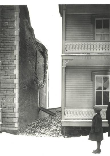
1925 Charlevoix-Kamouraska earthquake

1925 Charlevoix-Kamouraska earthquake

Earthquake
title = 1925 Charlevoix-Kamouraska earthquake
caption = Damage in Shawinigan, Quebec
date = February 28, 1925


magnitude = 6.2 Mw
depth = Unit km|10|0
location = coord|47.8|N|69.8|W
countries affected = Canada
tsunami = none
aftershocks = 55
casualties =

The 1925 Charlevoix-Kamouraska earthquake was a major earthquake that struck the entire northeastern part of North America on February 2, 1925, reaching 6.2 on the moment magnitude scale. [http://earthquakescanada.nrcan.gc.ca/historic_eq/20th/1925/19250301_e.php Natural Resources Canada: The 1925 Charlevoix-Kamouraska earthquake] ]

This earthquake is one of the most powerful earthquakes of the 20th century. The main shock epicenter occurred in the area of Quebec City and Shawinigan and was felt as far south as Virginia, and as far west as Mississippi. [ [http://earthquakescanada.nrcan.gc.ca/historic_eq/20th/1925/intensitew_e.php Natural Resources Canada: Intensity of the 1925 Charlevoix-Kamouraska Earthquake] ] It caused damage in three separate areas. The first had extreme damage constricted to a narrow belt 20 miles long on both shores of the Saint Lawrence River near the epicenter. [http://earthquakescanada.nrcan.gc.ca/historic_eq/20th/1925/dommage_e.php Natural Resources Canada: Damage caused by the 1925 Charlevoix-Kamouraska earthquake] ] In this area, damage at the villages of Baie-Saint-Paul, Saint-Urbain, Les Éboulements, Pointe-au-Pic, La Malbaie, Tadoussac and the other nearby villages of Ste-Anne-de-la-Pocatière, St-Pacôme, Rivière-Ouelle, Saint-Philippe, Saint-Denis, and Saint-Pascal on the south shore, was remaining mostly to the strength of the earthquake's irritation in some reasons by the deep grainy soil on which the destroyed buildings were built. The two other damaged areas were Quebec City and in the Trois-Rivières - Shawinigan regions where the destruction was worst, not so much to the strength of the earthquake, as to the uneven nature of the landscape. A total of 55 aftershocks were recorded, which lasted for weeks, ranging from magnitude 5 to 2. [ [http://earthquakescanada.nrcan.gc.ca/historic_eq/20th/1925/replique_e.php Natural Resources Canada: Aftershocks from the 1925 Charlevoix-Kamouraska earthquake] ] Over the years, several studies were published on the 1925 Charlevoix-Kamouraska earthquake, some as recently as 1999.

ee also

*List of earthquakes in Canada

References


Wikimedia Foundation. 2010.

Игры ⚽ Нужна курсовая?

Look at other dictionaries:

  • 1925 Charlevoix–Kamouraska earthquake — Damage in Shawinigan, Quebec Date February 28, 1925 (1925 02 28) Magni …   Wikipedia

  • Charlevoix — For other uses, see Charlevoix (disambiguation). The Charlevoix region, located in Quebec, includes parts of the north shore of the Saint Lawrence River and the Laurentian Mountains region of the Canadian Shield. This dramatic landscape includes… …   Wikipedia

  • 1925 — This article is about the year 1925. Millennium: 2nd millennium Centuries: 19th century – 20th century – 21st century Decades: 1890s  1900s  1910s  – 1920s –  1930s   …   Wikipedia

  • Charlevoix Seismic Zone — The Charlevoix Seismic Zone is a seismically active area in the Charlevoix region of northeastern Quebec, Canada. It is also known as the Charlevoix Kamouraska Seismic Zone because earthquakes occur in Kamouraska Country where the land expression …   Wikipedia

  • List of earthquakes in Canada — This is a list of earthquakes in Canada:*1663 Charlevoix earthquake *1700 Cascadia earthquake *1732 Montreal earthquake *1791 Charlevoix earthquake *1860 Charlevoix earthquake *1870 Charlevoix earthquake *1872 Washington earthquake *1918… …   Wikipedia

  • La Malbaie —   Municipality   …   Wikipedia

  • Saint Lawrence rift system — The Saint Lawrence rift system is a seismically active zone paralleling the Saint Lawrence River. The rift system trends northeast and southwest and forms a half graben that links the Ottawa Bonnechere and the Saguenay grabens. The rift system… …   Wikipedia

  • Baie-Saint-Paul, Quebec — Infobox City official name = Ville de Baie Saint Paul other name = native name = City of St. Paul s Bay nickname = motto = imagesize = 100px image caption = flag size = image seal size = image shield = shield size = image blank emblem = blank… …   Wikipedia

  • La Malbaie, Quebec — La Malbaie is a municipality in the Charlevoix Est Regional County Municipality in the province of Quebec, Canada, situated on the north shore of the Saint Lawrence River, at the mouth of the Malbaie River.The name La Malbaie, from the French for …   Wikipedia

  • Trois-Rivières — Infobox Settlement name = Trois Rivières, Quebec settlement type=City official name = Ville de Trois Rivières imagesize = 240px image caption = Boulevard des Forges, the main street of Trois Rivières. flag size = image seal size = image shield =… …   Wikipedia

Share the article and excerpts

Direct link
Do a right-click on the link above
and select “Copy Link”