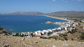
Charaki

Charaki
Charaki
Χαράκι
Charaki
Charaki
Location
Charaki is located in Greece
{{{alt}}}
Charaki
Coordinates 36°10′N 28°5′E / 36.167°N 28.083°E / 36.167; 28.083Coordinates: 36°10′N 28°5′E / 36.167°N 28.083°E / 36.167; 28.083
Government
Country: Greece
Region: South Aegean
Regional unit: Rhodes
Municipality: Rhodes
Municipal unit: Archangelos
Population statistics (as of 2001)
Village
 - Population: 119
Other
Time zone: EET/EEST (UTC+2/3)

Charaki (Greek: Χαράκι) is a small fishing village on the east coast of the island of Rhodes, Greece. In addition to its fishing trade, Haraki is also a small holiday resort, with the usual tavernas, restaurants and bars. Charaki has a small, picturesque bay with a number of holiday apartments in addition to its tavernas. More recently, the land behind the bay has been host to a small number of housing developments.

Charaki is only half an hour drive from the airport of Rhodos island,and 10 minutes drive from the town of Lindos.

On the acropolis overlooking Charaki is Feraclos Castle (aka Feraklos) (Greek Φεράκλος) - Feraclos was built by the Knights of St John, and was the last stronghold in Rhodes to succumb to the Ottoman Empire.From the Feraclos castle you can have a panoramic view of Charaki,the sandy beach of Agia Agathi,and more far to the south the town of Lindos.

Wild mountain sheep and moufflon inhabit the village's surrounding mountains. Generally, the animals congregate in the castle at dusk and remain there until sunrise.

Most inhabitants of Charaki are residents of the nearby agricultural village Malona.

Visible from Charaki bay is the acropolis of Lindos, the next major town to the village.

Situated on a similar half-moon bay, Charaki is slightly smaller than the Greek village of Stoupa near Kalamata on the Greek mainland.

Charaki was once rated one of the cleanest beaches of the Greek isles.

References


Wikimedia Foundation. 2010.

Игры ⚽ Нужен реферат?

Look at other dictionaries:

  • Charaki — (griechisch Χαράκι (n. sg.), auch Haraki) ist ein Fischerdorf an der Ostküste von Rhodos, das zum Gemeindebezirk Archangelos gehört. Es liegt etwa 8 km nördlich vom Gemeindezentrum. Oberhalb der Ortschaft liegt die Festungsruine… …   Deutsch Wikipedia

  • Haraki — Charaki (griechisch Χαράκι (n. sg.), auch Haraki) ist ein Fischerdorf an der Ostküste von Rhodos, das zur Gemeinde Archangelos gehört. Es liegt etwa 8 km nördlich vom Gemeindezentrum. Oberhalb der Ortschaft liegt die Festungsruine Feraklos. Die… …   Deutsch Wikipedia

  • charakiris — charaki̇̀ris dkt. Pasidaryti charaki̇̀rį …   Bendrinės lietuvių kalbos žodyno antraštynas

  • List of settlements in the Heraklion prefecture — These are a list of settlements in the Heraklion Prefecture, Crete, Greece.A ndash;B*Acharnes (Menidi) *Achentrias *Achlada *Afrati *Agia Foteini, also Agia Fotini *Agioi Paraskies *Agia Paraskevi *Agia Pelagia *Agia Varvara *Agioi Deka *Agion… …   Wikipedia

  • List of settlements in the Dodecanese prefecture — These are a list of settlements in the Dodecanese prefecture, Greece.In Astypalaia*Astypalaia *Livadia *VathyIn Kalymnos*Arginioti *Chorio *Emporio *Kalymnos *Massouri *Myrties *Panormos *Skalia *VathyIn Karpathos and Kassos*Agios Nikolaos… …   Wikipedia

  • Nikos Kazantzakis (municipality) — Nikos Kazantzakis Νίκος Καζαντζάκης Location …   Wikipedia

  • Feraklos — (auch Faraklos) ist die Ruine einer Festung an der Ostküste von Rhodos, nördlich von Charaki. Sie ist benannt nach dem seit der Antike besiedelten und befestigten Faraklos Hügel. Auf der Hügelgruppe wurde von den Byzantinern eine Festung gebaut,… …   Deutsch Wikipedia

  • Rethymno — Gemeinde Rethymno Δήμος Ρεθύμνου …   Deutsch Wikipedia

  • Charakas — Harakas, Charakas, Khrakas, Ελλ.Χάρακας is a village in the municipality of Archanes Asterousia on Crete, Greece with about 1000 inhabitants. It is about 45 km south from Heraklion, which is the largest city of Crete. The village lies on the… …   Wikipedia

  • Myrtia, Heraklion — Myrtia (Greek: Μυρτιά, Βάρβαρον Varvaron before 1965[1]) is a village in the northern part of the municipal unit Nikos Kazantzakis, Crete, Greece. It is 15 km from Heraklion. It is situated at an altitude of 365 meters from the sea. It… …   Wikipedia

Share the article and excerpts

Direct link
Do a right-click on the link above
and select “Copy Link”