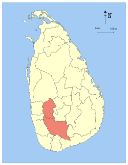
- Sabaragamuwa
-
Sabaragamuwa
සබරගමුව
சபரகமுவ— Province —
FlagLocation within Sri Lanka Country  Sri Lanka
Created 1889 Admitted 14 November 1987 Capital Ratnapura Largest City Ratnapura Government – Governor W. J. M. Lokubandara – Chief Minister Maheepala Herath Area – Total 4,902 km2 (1,892.7 sq mi) Area rank 8th (7.46% of total area) Population (2001) – Total 1,801,331 – Rank 5th (9.63% of total pop.) – Density 367.5/km2 (951.7/sq mi) Gross Regional Product (2010)[1] – Total Rs 303 billion – Rank 5th (6.3% of total) Time zone Sri Lanka (UTC+05:30) Official Languages Sinhala, Tamil Website sabaragamuwapc.com Sabaragamuwa, (Sinhala: සබරගමුව Sabaragamuwa, Tamil: சபரகமுவ Sabaragamuwa) is a province of Sri Lanka, and contains two main cities: Ratnapura and Kegalle. Sabaragamuwa University is in Belihuloya. It is named after its former indigenous inhabitants, namely the Sabara, an indic term for hunter gatherer tribes, a term seldom used in ancient Sri Lanka.
Contents
Districts
Sabaragamuwa is divided into 2 districts:
- Kegalle District 1,663 km2 (642 sq mi)
- Ratnapura District 3,237 km2 (1,250 sq mi)
Ratnapura
At an elevation of approximately 500 feet above sea level, Ratnapura is the provincial capital of Sabargamuwa. It is 60 miles (100 km) from the main coastal city of Colombo.
See also
References
External links

Western Province North Western Province Central Province 
Western Province 
Central Province  Sabaragamuwa Province

Southern Province Southern Province Uva Province
Southern ProvinceProvinces of Sri Lanka Categories:- Sabaragamuwa Province
- Provinces of Sri Lanka
- Kingdom of Kandy
- Sri Lanka geography stubs
Wikimedia Foundation. 2010.


