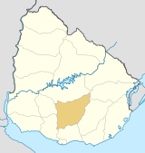
- Cerro Colorado, Uruguay
-
Cerro Colorado — Village — Location in Uruguay Coordinates: 33°52′0″S 55°33′0″W / 33.866667°S 55.55°WCoordinates: 33°52′0″S 55°33′0″W / 33.866667°S 55.55°W Country  Uruguay
Department Florida Department Population (2004) - Total 1,336 Time zone UTC -3 Postal code 94101 Area code(s) +598 4318 Cerro Colorado is a village in the Florida Department of southern-central Uruguay. It is located on Route 7, about 140 kilometres (87 mi) northeast of Montevideo.
Population
In 2004 it had a population of 1,336.[1]
Year Population 1963 593 1975 906 1985 1,092 1996 1,170 2004 1,336 Source: Instituto Nacional de Estadística de Uruguay[2]
References
- ^ "2004 Census of Florida department" (XLS). INE. 2004. http://www.ine.gub.uy/fase1new/Florida/Cuadro7_08.XLS. Retrieved 27 June 2011.
- ^ "1963–1996 Statistics / C" (DOC). Instituto Nacional de Estadística de Uruguay. 2004. http://www.ine.gub.uy/biblioteca/toponimico/TOPOletraC.doc. Retrieved 27 June 2011.
External links
 Florida Department of Uruguay
Capital: Florida Towns and
villagesCapilla del Sauce • Cardal • Casupá • Cerro Chato • Cerro Colorado • Chamizo • Florida • Fray Marcos • La Cruz • Mendoza • Mendoza Chico • Nico Pérez • Sarandí Grande • Veinticinco de Agosto • Veinticinco de Mayo

Sights Categories:- Uruguay geography stubs
- Populated places in the Florida Department
Wikimedia Foundation. 2010.

