Ceraunian Mountains

Ceraunian Mountains
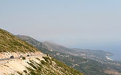
View from Llogara pass to the southeast.

The Ceraunian Mountains (Albanian: Mal i Kanalit, Greek: Κεραύνια όρη, Keravnia ori; Latin: Cerauni montes) is a coastal mountain range in southwestern Albania. The name is derived from Ancient Greek Κεραύνια ὄρη[1][2], meaning "thunder-split peaks".[3]

The range extends approximately 100 km along the coast in a northwesterly direction from the Greek border to the Strait of Otranto. The highest peak is Çika, (2012 m).[4] The Llogara Pass (1027 m) divides the mountains into a western and an eastern range. The western chain are also known as Acroceraunian Mountains. In some places the mountains fall directly into the sea.

The Ceraunian Mountains have been described by ancient writers such as Ptolemy, Strabo and Pausanias. Consequently their classical Greek name is better known than the modern Albanian one.

Julius Caesar first set foot on Llogara Pass and rested his legion at Palase on the Albanian Riviera during his pursuit of Pompey.

References

  1. ^ Strabo, Geography, Book VI, 3.5 at LacusCurtius
  2. ^ Strabo, Geography Book VII, 5.1 LacusCurtius
  3. ^ Keraunia, Henry George Liddell, Robert Scott, A Greek-English Lexicon, at Perseus
  4. ^ http://www.geonames.org/3185881/maja-e-cikes.html

Wikimedia Foundation. 2010.

Игры ⚽ Поможем решить контрольную работу

Look at other dictionaries:

  • Himarë — This article is about the municipality. For the town, see Himarë (town). Himarë   Municipality   …   Wikipedia

  • Dhërmi —   Village   A view of the Dhermi Village …   Wikipedia

  • Northern Epirus — Note: For the autonomous state formed in the region at 1914, see: Autonomous Republic of Northern Epirus. The region of Epirus, stretching across Greece and Albania. Legend grey: Approximate extent of Epirus in antiquity orange: Greek periphery… …   Wikipedia

  • Ceraunius Fossae — MOLA colorized image of Ceraunius Fossae region. The fractured terrain consists of two large patches of north south trending faults surrounded by lava flows. The Alba Mons volcano is the large, circular feature at top …   Wikipedia

  • Epirus (region) — Epirus (from Ionic Greek Ήπειρος Ēpeiros , Doric Greek: Ἅπειρος Apeiros , in Albanian: Epir or Epiri ) is a region in south eastern Europe, currently divided between the periphery of Epirus in Greece (80%) and Northern Epirus in southern… …   Wikipedia

  • Ancient Greece — The Parthenon, a temple dedicated to Athena, located on the Acropolis in Athens, is one of the most representative symbols of the …   Wikipedia

  • Nireus — This article is about the hero of the Trojan War. For other uses, see Nireus (disambiguation). In Greek mythology, Nireus, son of King Charopus and Aglaea, was king of the island Syme (according to Diodorus Siculus,[1] also of a part of Cnidia)… …   Wikipedia

  • Chaonia — Tribes of Epirus in antiquity. Chaonia or Chaon (Greek Χαονία or Χάων) was the name of the northwestern part of Epirus, the homeland of the Greek tribe of the Chaonians.[1] …   Wikipedia

  • Chaonians — Tribes of Epirus in antiquity. The Chaonians (Greek: Χάονες, Chaones) were an ancient Greek tribe that inhabited the region of Epirus located in the north west of modern Greece and southern Albania …   Wikipedia

  • Metrodorus of Scepsis — For other people of the same name, see Metrodorus. Metrodorus of Scepsis (c. 145 BCE – 70 BCE), from the town of Scepsis in ancient Mysia, was a friend of Mithridates VI of Pontus and celebrated in antiquity for the excellence of his memory. He… …   Wikipedia

Share the article and excerpts

Direct link
Do a right-click on the link above
and select “Copy Link”