- Semeru
-
For the yaoi term, see seme and uke.
Semeru 
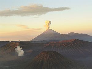
Semeru in 1985.Elevation 3,676 m (12,060 ft) Prominence 3,676 m (12,060 ft)
Ranked 44thListing Ultra
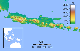
RibuLocation Java, Indonesia Coordinates 8°6′28.8″S 112°55′12.0″E / 8.108°S 112.92°ECoordinates: 8°6′28.8″S 112°55′12.0″E / 8.108°S 112.92°E Geology Type Stratovolcano Last eruption 2011 (continuing) Climbing First ascent Unknown Easiest route Hike Semeru, or Mount Semeru (Indonesian: Gunung Semeru), is a volcano located in East Java, Indonesia. It is the highest mountain on the island of Java. The stratovolcano is also known as Mahameru, meaning 'The Great Mountain.[1] The name derived from Hindu-Buddhist mythical mountain of Meru or Sumeru, the abode of gods.
Contents
Geology
Known also as Mahameru the (Great Mountain), it is very steep rising abruptly above the coastal plains of eastern Java. Maars containing crater lakes have formed along a line through the summit of the volcano. It was formed south of the overlapping Ajek-ajek and Jambagan calderas.[1] Semeru lies at the south end of the Tengger Volcanic Complex.
Eruptive history
Semeru's eruptive history is extensive. Since 1818, at least 55 eruptions have been recorded (10 of which resulted in fatalities) consisting of both lava flows and pyroclastic flows. All historical eruptions have had a VEI of 2 or 3.[1]
Semeru has been in a state of near-constant eruption from 1967 to the present. At times, small eruptions happen every 20 minutes or so.[2]
Semeru is regularly climbed by tourists, usually starting from the village of Ranu Pane to the north, but though non-technical it can be dangerous. Soe Hok Gie, an Indonesian political activist of the 1960s died in 1969 from inhaling poisonous gases while hiking on Mount Semeru.[citation needed]
Mythology
Semeru is named from Sumeru, the central world-mountain in Buddhist cosmology and by extension Hinduism. As stated in legend, it was transplanted from India; the tale is recorded in the 15th-century East Javanese work Tantu Pagelaran. It was originally placed in the western part of the island, but that caused the island to tip, so it was moved eastward. On that journey, parts kept coming off the lower rim, forming the mountains Lawu, Wilis, Kelut, Kawi, Arjuno and Welirang. The damage thus caused to the foot of the mountain caused it to shake, and the top came off and created Penanggungan as well.[3]
See also
- List of volcanoes in Indonesia
- List of Southeast Asian mountains
- List of islands by highest point
- Volcanological Survey of Indonesia
Notes
- ^ a b c "Semeru: Summary". Global Volcanism Program, Smithsonian Institution. http://www.volcano.si.edu/world/volcano.cfm?vnum=0603-30=.
- ^ http://www.abc.net.au/news/stories/2009/03/06/2509895.htm?section=justin for March 2009 eruption
- ^ Soekmono, Dr R. (1973). Pengantar Sejarah Kebudayaan Indonesia 2. Yogyakarta, Indonesia: Penerbit Kanisius. pp. 119. ISBN 979-413-290-X.
References
- "Semeru". Global Volcanism Program, Smithsonian Institution. http://www.volcano.si.edu/world/volcano.cfm?vnum=0603-30=.
- Holt, Claire. Art in Indonesia: Continuities and Change. Ithaca: Cornell University Press, 1967. Page 36 explains the mythological aspect of the mountain.
External links
Categories:- Stratovolcanoes
- Mountains of Indonesia
- Volcanoes of Java
- Active volcanoes of Indonesia
- Maars of Indonesia
- Crater lakes
Wikimedia Foundation. 2010.


