Akajima

Akajima

Infobox Islands
name = Akajima
阿嘉島


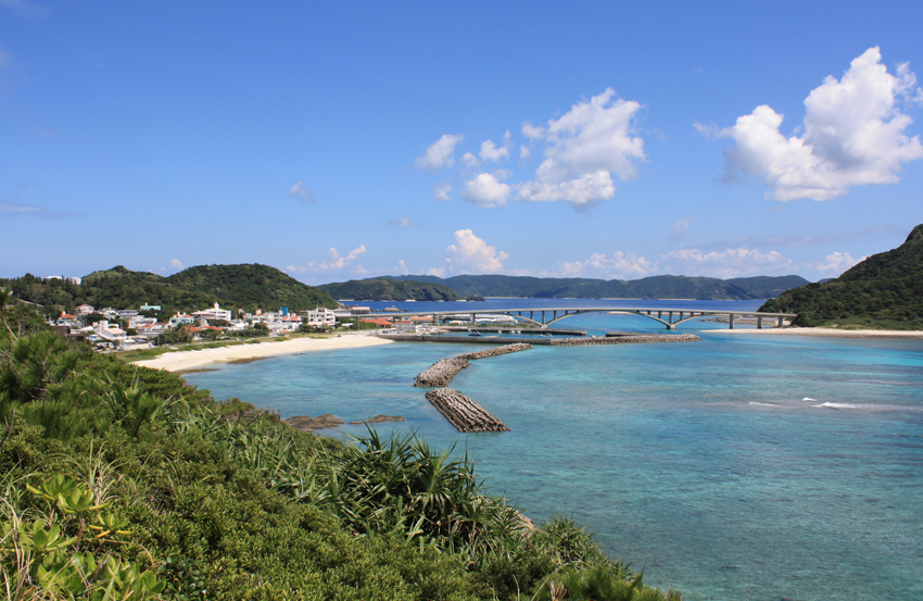
image caption = View of the bridge that links Akajima to Gerumajima
image size =
locator

native name =
native name link =
nickname =
location = East China Sea
coordinates =
archipelago =
total islands =
major islands =
area =
highest mount =
elevation =
country = Japan
country admin divisions title =
country admin divisions =
country admin divisions title 1 =
country admin divisions 1 =
country admin divisions title 2 =
country admin divisions 2 =
country capital city =
country largest city =
country largest city population =
country leader title =
country leader name =
population =
population as of =
density =
ethnic groups =
additional info =

Nihongo|Akajima|阿嘉島|Akashima is one of the Kerama Islands in Okinawa Prefecture, Japan.

The island is commonly known as Aka and is located 20 miles to the southwest of Okinawa Island. It is one of four main inhabited islands in the Kerama group and is linked via a road bridge to Gerumajima.

History

Aka was one of the first landing places for US Forces in the Battle of Okinawa. US Forces landed on March 26, 1945 and went on to take Zamamijimi, Gerumajimi and Tokashikijimi Islands. Over 500 residents committed suicide by order of the Japanese troops in order to avoid capture.


Wikimedia Foundation. 2010.

Игры ⚽ Нужна курсовая?

Look at other dictionaries:

  • Акадзима — Координаты: 26°11′56.4″ с. ш. 127°16′50″ в. д. / 26.199002, 127.280556  …   Википедия

  • Kerama Islands — Native name: 阿嘉島 Sea view of Kerama Islands with surrounding coral reefs …   Wikipedia

  • Okinawa Islands — Okinawa Island with Daito Islands missing Okinawa Islands (沖縄諸島 Okinawa Shotō) are a group of islands that belongs to Okinawa Prefecture. Okinawa Prefecture makes up a portion of the Ryukyu Islands. The prefectural capital Naha, as well as most… …   Wikipedia

  • Ryukyu Islands — Ryukyu redirects here. For other uses, see Ryukyu (disambiguation). Ryukyu Islands Native name: 琉球諸島 (Ryūkyū shotō)[citation needed] Nansei Islands (南西諸島 Nansei shotō)[citation needed] …   Wikipedia

  • Kerama Airport — Infobox Airport name = Kerama Airport nativename a = 慶良間空港 nativename r = Kerama Kūkō IATA = KJP ICAO = ROKR type = Public owner = operator = Okinawa Prefecture city served = Kerama Islands location = Zamami, Okinawa, Japan elevation f = 156… …   Wikipedia

  • Liste der Inseln der Präfektur Okinawa — Diese Liste der Inseln der Präfektur Okinawa erfasst, in Inselgruppen gegliedert, alle, auch kleine, unbewohnte, Inseln der Präfektur Okinawa, wenn sie in zumindest einer verlässlichen japanischen Quelle als Insel ( 島, shima, tō) und nicht nur… …   Deutsch Wikipedia

  • Liste japanischer Inseln — Inhaltsverzeichnis 1 Hauptinseln 2 Weitere Inseln (> 60 km²) 3 Inseln nach Inselgruppen geordnet 3.1 Inseln im Japanisches Meer …   Deutsch Wikipedia

  • Liukiu-Inseln — Karte Japans, Ryūkyū Inseln markiert Die Lage der Ryūkyū Inseln zwischen Japan, China und Taiwan Die Ryūkyū Inseln (veraltet: Riukiu Inseln oder Liukiu Inseln; jap …   Deutsch Wikipedia

  • Nansei-Inseln — Mit Nansei Inseln (jap. 南西諸島, Nansei shotō, wörtlich: „südwestliche Inseln“) werden alle Inseln bezeichnet, die von Japan aus südlich des 31. Breitengrades liegen und zum japanischen Staat gehören (außer den Ogasawara Inseln). Hauptinselgruppen… …   Deutsch Wikipedia

  • Nansei-shoto — Dieser Artikel oder Abschnitt bedarf einer Überarbeitung. Näheres ist auf der Diskussionsseite angegeben. Hilf mit, ihn zu verbessern, und entferne anschließend diese Markierung. Mit Nansei Inseln (jap. 南西諸島, Nansei shotō, wörtlich: „südwestliche …   Deutsch Wikipedia

Share the article and excerpts

Direct link
Do a right-click on the link above
and select “Copy Link”