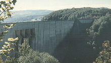
- Mossyrock Dam
-
Mossyrock Dam 
Mossyrock DamLocation Lewis County, Washington, USA Coordinates 46°32′4″N 122°25′34″W / 46.53444°N 122.42611°WCoordinates: 46°32′4″N 122°25′34″W / 46.53444°N 122.42611°W[1] Construction began 1965 Opening date 1968[2] Construction cost $117,769,400[3] Dam and spillways Type of dam Concrete, arch-gravity Height 606 feet (185 m)[2] Length 1,648 feet (502 m)[2] Impounds Cowlitz River Type of spillway Service, gate-controlled Reservoir Creates Riffe Lake Capacity 1,685,000 acre feet (2.08 km3)[2] Catchment area 1,042 square miles (2,700 km2)[2] Surface area 11,830 acres (47.9 km2)[2] Mossyrock Dam is a concrete arch-gravity dam on the Cowlitz River near Mossyrock in Lewis County, Washington. The reservoir created by the dam is called Riffe Lake and the primary purpose of the dam is hydroelectric production while flood control is secondary.[2] The dam is the tallest in Washington State and its hydroelectric power station supplies 40% of Tacoma Power's electricity.[4][5]
Contents
History
The Mossy Rock Dam was originally planned in the 1940s but opposition from local fishers and Washington State's Game Department delayed construction. During World War II, the city of Tacoma purchased its electricity from the Bonneville Power Administration and Seattle which would cost as much as $1 million a year. To generate its own electricity, Tacoma City Light, now known as Tacoma Power would build several dams including the Mossyrock Dam. Plans for the Mossyrock Dam were announced in 1948 but met stiff opposition. The Washington State Legislature enacted a fish sanctuary on the Cowlitz River that initially blocked the project. The City of Tacoma then went to court and after the case was before the U.S. Supreme Court three times, the dam was approved. Construction began in 1965 and ended in 1968. On October 13, 1968, the dam's power plant generated its first electricity.[6]
Power plant
The Mossyrock Dam's power plant contains 2 x 150 MW Francis turbine hydroelectric generators totaling a 300 MW capacity. The generators are fed by three penstocks ranging from 248 – 285 ft. feet long.[4] One of the three penstocks is unused as the plant has an additional space for one more generator.[3]
Power plant upgrade
In 2006, GE Energy was selected to upgrade both of the power plant's generators.[4] The $50 million dollar project includes replacing the turbines, stators, wicket gates and transformers among other improvements.[7] Installation of the first generator began in 2008 and was completed and commissioned in 2009.[8] The second generator was completed in later 2010. The power plant upgrade will increase the total capacity by 70 MW and it should operate around 95% efficiency.[5]
External links
References
- ^ U.S. Geological Survey Geographic Names Information System: Mossyrock Dam
- ^ a b c d e f g Mossyrock Dam, NPDP Dam Directory
- ^ a b Cowlitz River Project Statistics, Tacoma Power
- ^ a b c "Hydroelectric Plants in Washington". industcards, Platts UDI World Electric Power Plants Data Base. http://www.industcards.com/hydro-usa-wa.htm. Retrieved 10 July 2010.
- ^ a b "TURBINE GENERATOR UPGRADE TACOMA PUBLIC UTILITIES MOSSYROCK DAM CENTRALIA, WA". NAES Power Contractors. http://www.naes.com/NPC/ProjectPortfolio/Mossyrock%20Turbine%20Generator%20Upgrade.pdf. Retrieved 10 July 2010.
- ^ Wilma, David (December 16, 2002). "Tacoma City Light's Mossyrock Dam on the Cowlitz River generates electricity on October 13, 1968.". History Link.org. http://www.washington.historylink.org/index.cfm?DisplayPage=output.cfm&File_Id=5026. Retrieved 10 July 2010.
- ^ "Tacoma Power’s Mossyrock Dam up for renewable energy award". Tacoma Power. http://www.mytpu.org/newsroom/power-news/tacoma-powers-mossyrock.htm. Retrieved 10 July 2010.
- ^ "WEEKLY REPORT TO THE CITY COUNCIL April 2, 2009 Members of the City Council City of Tacoma, Washington". City of Tacoma,. http://cms.cityoftacoma.org/cityclerk/Files/CityCouncil/CMOWeeklyReport/2009/WklyReport20090402.pdf. Retrieved 10 July 2010.
Categories:- Dams in Washington (state)
- Hydroelectric power plants in Washington (state)
- Buildings and structures in Lewis County, Washington
- Arch-gravity dams
Wikimedia Foundation. 2010.
