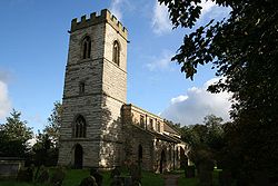
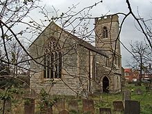
St. Giles' Church, Cromwell
- St. Giles' Church, Cromwell
-
Coordinates: 53°08′42″N 00°48′23″W / 53.145°N 0.80639°W / 53.145; -0.80639
St. Giles' Church, Cromwell is a parish church in the Church of England in Cromwell, Nottinghamshire.
The church is Grade I listed by the Department for Culture, Media & Sport as a building of outstanding architectural or historic interest.
History
The church was medieval but restored in 1873 to 1876 by Ewan Christian. The church is largely 13th century with the tower being built around 1427.[1]
Pipe Organ
The church has a small single manual pipe organ. A specification of the organ can be found on the National Pipe Organ Register
Current parish status
It is in a group of parishes which includes:
Source
- ^ Pevsner, Nikolaus. 1979. The Buildings of England:Nottinghamshire. page 108. Harmondsworth, Middx. Penguin.
Categories: - Church of England churches in Nottinghamshire
- Grade I listed buildings in Nottinghamshire
- Grade I listed churches
Wikimedia Foundation.
2010.
Look at other dictionaries:
Cromwell, Nottinghamshire — Coordinates: 53°08′N 0°49′W / 53.14°N 0.81°W / 53.14; 0.81 … Wikipedia
St. Laurence's Church, Norwell — Coordinates: 53°08′50″N 00°50′28″W / 53.14722°N 0.84111°W / 53.14722; 0.84111 … Wikipedia
Holy Rood Church, Ossington — Coordinates: 53°10′40″N 00°51′57″W / 53.17778°N 0.86583°W / 53.17778; 0.86583 … Wikipedia
St. Andrew's Church, Caunton — Coordinates: 53°07′55″N 00°53′12″W / 53.13194°N 0.88667°W / 53.13194; 0.88667 … Wikipedia
Oliver Cromwell — Cromwell redirects here. For other uses, see Cromwell (disambiguation). For other people named Oliver Cromwell, see Oliver Cromwell (disambiguation). Oliver Cromwell Portrait of Oliver Cromwell by Samuel Cooper … Wikipedia
St Giles-without-Cripplegate — Infobox church name = St. Giles without Cripplesgate fullname = color = imagesize = caption = Current photo of St. Giles without Cripplegate landscape = denomination = Anglican, earlier Roman Catholic diocese = parish = division = subdivision =… … Wikipedia
St Giles-without-Cripplegate — 51.518716666667 0.094041666666669 Koordinaten … Deutsch Wikipedia
Shaftesbury, Anthony Ashley Cooper, 1st Earl of, Baron Cooper of Pawlett, Baron Ashley of Wimborne St. Giles — ▪ English politician [1621 83] Introduction also called (from 1631) Sir Anthony Ashley Cooper, 2nd Baronet born July 22, 1621, Wimborne St. Giles, Dorset, Eng. died Jan. 21, 1683, Amsterdam, Neth. English politician, a member of the… … Universalium
Collegiate Church of St Mary Youghal — Coordinates: 51°57′18″N 7°51′13″W / 51.95503°N 7.85358°W / 51.95503; 7.85358 … Wikipedia
St. Michael's Parish Church, Linlithgow — St. Michael s Parish Church is one of the largest burgh churches in the Church of Scotland. It is one of two parishes serving the West Lothian county town of Linlithgow, the other being St. Ninian s Craigmailen. St Michael is the town s patron… … Wikipedia


