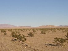
- Dumont Dunes
-
Dumont Dunes is an area of the Mojave Desert containing large sand dunes, located approximately 31 miles north of Baker, California on California State Route 127. Bordered by steep volcanic hills and the slow running Amargosa River, the region is easily recognized from a distance by its distinctive sand dunes. The elevation here varies from 700 feet, at the river, to 1200 feet at the top of Competition Hill, the tallest of the dunes.
Most of the dunes are incorporated in the Dumont Dunes Off-Highway Vehicle Area, which is administered by the Bureau of Land Management as a recreational area for off-road vehicle sports, hiking, camping, rock climbing, and rock collecting.[1]
The historic Tonopah and Tidewater Railroad, to the east, was in operation between 1905 and 1940. The vegetation here consists of creosote scrub, some annual grasses, and wildflowers in the spring. The low elevation in the area makes for warm to extremely hot conditions in spring and summer.
Contents
Wildlife
Wildlife native to Dumont Dunes includes the Mojave fringe-toed lizard, which is under watch by the U.S. Fish and Wildlife Service for possible listing as an endangered species. Such listing could result in restriction or suspension of recreational uses at Dumont Dunes.[2]
See also
Coordinates: 35°41′00″N 116°13′10″W / 35.6833333°N 116.21944°W[3]
References
 This article incorporates public domain material from websites or documents of the Bureau of Land Management.
- ^ Bureau of Land Management. "Dumont Dunes Off-Highway Vehicle Area". U.S. Department of the Interior. http://www.blm.gov/ca/st/en/fo/barstow/dumont.html. Retrieved 2008-09-01.
- ^ Rogers, Keith (2008-01-11). "Officials seek to protect desert reptile". Las Vegas Review-Journal. http://www.lvrj.com/news/13702907.html. Retrieved 2008-09-01.
- ^ "Dumont Dunes". Geographic Names Information System, U.S. Geological Survey. http://geonames.usgs.gov/pls/gnispublic/f?p=gnispq:3:::NO::P3_FID:1667894.
External links
Categories:- Mojave Desert
- Landforms of San Bernardino County, California
- Bureau of Land Management areas in California
- Off-roading
- Dunes of the United States
Wikimedia Foundation. 2010.


