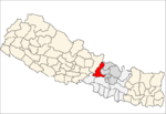
- Darkha
-
Darkha — Village development committee — Location in Nepal Coordinates: 28°04′N 85°01′E / 28.07°N 85.01°ECoordinates: 28°04′N 85°01′E / 28.07°N 85.01°E Country  Nepal
NepalZone Bagmati Zone District Dhading District Population (1991) – Total 4,979 – Religions Buddhist Time zone Nepal Time (UTC+5:45) Darkha is a village development committee in Dhading District in the Bagmati Zone of central Nepal. At the time of the 1991 Nepal census it had a population of 4979 and had 910 houses in it.[1]
References
- ^ "Nepal Census 2001". Nepal's Village Development Committees. Digital Himalaya. http://www.digitalhimalaya.com/collections/nepalcensus/form.php?selection=1. Retrieved 2008-08-24.
Agnichok · Baireni · Baseri · Benighat · Bhumesthan · Budhathum · Chainpur · Chhatre Dyaurali · Darkha · Dhola · Dhussa · Dhuwakot · Gajuri · Gaunkharka · Gerkhu · Ghussa · Goganpani · Gumdi · Jeewanpur · Jharlang · Jogimara · Jyamaruk · Kalleri · Katunge · Kebalpur · Khalte · Khari · Kiranchok · Kumpur · Lapa · Mahadevsthan · Maidi · Marpak · Mulpani · Murali Bhanjyang · Nalang · Naubise · Nilkantha
· Phulkharka · Pida · Ree Gaun · Salang · Salyankot · Salyantar · Sangkosh · Satyadevi · Semjong · Sirtung · Sunaula Bazar · Tasarpu · Thakre · Tipling · Tripureswor
Darkha is verry beauti of natural. and darkha is east border of satyadevi and aakhu border in the south,jharlang border is west fraom darkha we can see beauty schene of ganesh himal. such this is nice v.d.c.
Categories:- Populated places in Dhading District
- Bagmati Zone geography stubs
Wikimedia Foundation. 2010.

