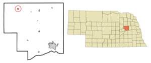
- Lindsay, Nebraska
Infobox Settlement
official_name = Lindsay, Nebraska
settlement_type = Village
nickname =
motto =
imagesize =
image_caption =
image_
imagesize =
image_caption =
image_
mapsize = 250px
map_caption = Location of Lindsay, Nebraska
mapsize1 =
map_caption1 =subdivision_type = Country
subdivision_name =United States
subdivision_type1 = State
subdivision_name1 =Nebraska
subdivision_type2 = County
subdivision_name2 = Platte
government_footnotes =
government_type =
leader_title =
leader_name =
leader_title1 =
leader_name1 =
established_title =
established_date =unit_pref = Imperial
area_footnotes =area_magnitude =
area_total_km2 = 0.9
area_land_km2 = 0.9
area_water_km2 = 0.0
area_total_sq_mi = 0.3
area_land_sq_mi = 0.3
area_water_sq_mi = 0.0population_as_of = 2000
population_footnotes =
population_total = 276
population_density_km2 = 312.0
population_density_sq_mi = 808.0timezone = Central (CST)
utc_offset = -6
timezone_DST = CDT
utc_offset_DST = -5
elevation_footnotes =
elevation_m = 515
elevation_ft = 1690
latd = 41 |latm = 42 |lats = 2 |latNS = N
longd = 97 |longm = 41 |longs = 41 |longEW = Wpostal_code_type =
ZIP code
postal_code = 68644
area_code = 402
blank_name = FIPS code
blank_info = 31-28105GR|2
blank1_name = GNIS feature ID
blank1_info = 0830744GR|3
website =
footnotes =Lindsay is a village in Platte County,
Nebraska ,United States . The population was 276 at the 2000 census.Geography
Lindsay is located at coor dms|41|42|2|N|97|41|41|W|city (41.700622, -97.694605)GR|1.
According to the
United States Census Bureau , the village has a total area of 0.3square mile s (0.9km² ), all of it land.History
Founding and Naming
In 1862, subject to the provisions of the
Homestead Act , Families began settling int the fertile land near Shell Creek. The first settler, John M. Walker named the town for the common hometown of many early settlers,Lindsay, Ontario ,Canada . By 1886, with the addition of settlers of German ancestry, the population reached about 200, and it received "village" status on March 7, 1888. cite Web|url=http://www.megavision.net/lindsay/historyparagraph.htm |title=A Brief History About Lindsay |Publisher=Darci Lindgren |accessdate=2008-05-01]Early 20th Century
By the early 20th Century, Lindsay had an electric utility and water system comprising a 100-ft well and a 60,000 gallon tank. Business establishments included one each of:
*hotel
*opera house
*natural park
*livery barn
*shoe shop
*barbershop
*jewelry store
*harness shop
*furniture store
*implement store
*flour and feed store. Lindsay also had two each of:
*drug store
*bank
*restaurant
*lumber yard
*meat market
*cream station
*hardware store
*blacksmith shops
*schools (one public, one private)
*churches (oneRoman Catholic , oneMethodist )And three each of:
*saloons
*grain elevators
*mail routes
*general stores.The
Chicago and North Western Railroad 's Albion Line consisted of 115 miles of tracks through Lindsay, on which were operated four freight trains and two passenger trains daily. By 1917, the population of Lindsay had grown to almost 500 people.Lindsay Corporation
What is now the Lindsay Corporation was founded in the village in 1955 by Paul Zimmerer as the Lindsay Manufacturing Company to be a maker of irrigation and farm automation equipment. The company has retained a manufacturing facility in Lindsay, but is now headquartered in
Omaha, Nebraska and its stock is traded on theNew York Stock Exchange with a ticker symbol of LNN. In 2005, the company accounted for 80% of employment in Lindsay, employing about 460 persons of the village's total employment of 577. [ [http://censtats.census.gov/ CenStats Databases] ] U.S. Census Bureau, Retrieved on 05-01-2008 for ZIP Code 68644 ]Demographics
As of the
census GR|2 of 2000, there were 276 people, 124 households, and 73 families residing in the village. Thepopulation density was 808.0 people per square mile (313.4/km²). There were 136 housing units at an average density of 398.1/sq mi (154.4/km²). The racial makeup of the village was 100.00% White. Hispanic or Latino of any race were 0.36% of the population.There were 124 households out of which 25.0% had children under the age of 18 living with them, 54.8% were married couples living together, 3.2% had a female householder with no husband present, and 41.1% were non-families. 40.3% of all households were made up of individuals and 19.4% had someone living alone who was 65 years of age or older. The average household size was 2.23 and the average family size was 3.07.
In the village the population was spread out with 24.6% under the age of 18, 6.9% from 18 to 24, 21.4% from 25 to 44, 23.2% from 45 to 64, and 23.9% who were 65 years of age or older. The median age was 43 years. For every 100 females there were 112.3 males. For every 100 females age 18 and over, there were 110.1 males.
The median income for a household in the village was $32,232, and the median income for a family was $45,313. Males had a median income of $28,750 versus $17,500 for females. The
per capita income for the village was $17,103. About 3.7% of families and 10.6% of the population were below thepoverty line , including 10.5% of those under the age of eighteen and 13.2% of those sixty five or over.References
External links
Wikimedia Foundation. 2010.


