- Holywell Green
-
Coordinates: 53°40′30″N 1°51′59″W / 53.675000°N 1.866404°W
Holywell Green 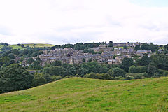
Holywell Green, from Broad Carr Lane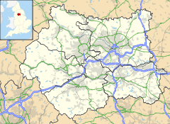
 Holywell Green
Holywell Green shown within West YorkshirePopulation 2,831 (with Stainland) (2001 Census) OS grid reference SE089198 Metropolitan borough Calderdale Metropolitan county West Yorkshire Region Yorkshire and the Humber Country England Sovereign state United Kingdom Post town HALIFAX Postcode district HX4 Dialling code 01422 Police West Yorkshire Fire West Yorkshire Ambulance Yorkshire EU Parliament Yorkshire and the Humber UK Parliament Calder Valley List of places: UK • England • Yorkshire Holywell Green is a small village in Calderdale, West Yorkshire, England. It is 3.5 miles (5.6 km) south of Halifax, 4 miles (6.4 km) north-west of Huddersfield and 1.5 miles (2.4 km) south-west of Elland.
Contents
History
Holywell Green was recorded in the Domesday book as being "a small hamlet within the township of Stainland." The area gets its name from St. Helen's Well which was very famous in the area in the medieval times. The importance of the well can be seen by the public house in Holywell Green named 'The Holywell Inn'. The place of the actual Holy Well is a topic of debate. It could be St. Helen's Well itself, the spring in Shaw Park, behind the chapel or at the top of Thomas Street.
Geography
Holywell Green is the name given to the east side of Stainland. It is based around Stainland Road and Station Road. It is built on an east-facing hill.
Since West View and Bradley View were built, it has been hard to distinguish the difference between Stainland and Holywell Green.
The centre of Holywell Green is apparently marked by an old oak tree in Shaw Park, close to the Station Road entrance and the Brooklands Avenue entrance.
Landmarks
Shaw Park
Shaw Park is the biggest park in the area. The main entrance is located off Station Road. The park was the garden of Brooklands House until the house's demolition in 1930. In 1955, Raymond Shaw gave the garden to Elland UDC and then became a public park. It has a playground, an astroturf 5-a-side football pitch , a well, an ornamental lake, a reed pond, some arches, three follies and some woods. The three follies are located at the top of the park and were built by John Shaw as aviaries. Shaw Park is accessible by four entrances: Shaw Lane next to Brooklands Avenue, Shaw Lane next to Brooklands Close, the very bottom of Shaw Lane and Station Road.
In 2010 a group was formed to restore the park back to its former glory as it had been neglected by the council and allowed to fall into a rundown state.[1]
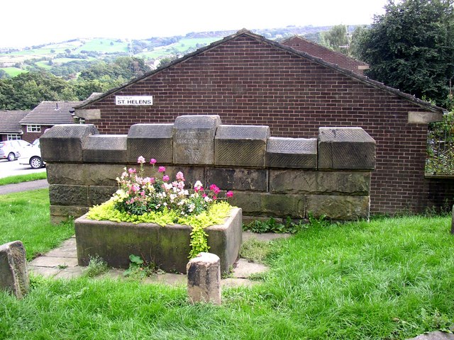
St. Helen's Well
St. Helen’s Well is mentioned in John Watson's monumental The History and Antiquities of the Parish of Halifax, 1775. He gives no description but says a Roman Catholic chapel dedicated to St Helen, nearby had been converted into a cottage, but in its walls was a large stone known locally as 'the Cross'. Strangers, presumed to be Catholics, made pilgrimages to the well. Watson also possessed a deed which mentioned a grant made to Henry de Sacro Fonte de Staynland. dated between 1279 and 1324. The well was restored in 1843 in response to interest in drinking 'spa' water. The 'Halifax Guardian' for September 1842 described the scene around Well Head spa where crowds carrying drinking utensils jostled each other in their eagerness to take the waters. Well Head was the most popular of the Halifax spas but several other springs in the area were frequented. Similar scenes may have occurred around this well. In the late 19th century the well was declining. The stone trough had cracked and was leaking. Local placenames reflect the importance of the well. The village is known as Holywell Green and there is a pub called 'The Holywell Inn' and a 'St Helen’s Court'. The well was further restored in 1977 and the crumbling trough of the woodcut has been replaced by a solid modern one, no water flows into it.
 St. Helen's Well
Carr Hall Castle
Carr Hall Castle is at the end of Shaw Lane. It won Five's TV show I Own Britain's Best Home in 2008.
Bradley Hall Golf Club
Across from Burrwood Way's junction with Stainland Road is a road which leads to Bradley Hall Golf Club. The clubhouse is, as the name suggests, Bradley Hall. The golf course is spread out along the side of the hill below Stainland. Bradley Hall itself was built in the 16th century. It was badly damaged by a fire in 1629. Many local places were named after the hall, including Bradley Court, Bradley Lane, Bradley Farm and Little Bradley, all in Greetland, and Bradley View in Holywell Green.
Pubs and restaurants
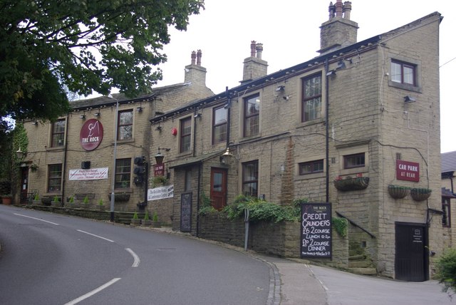
Located at the bottom of Broad Carr Lane is The Rock Hotel which has 27 bedrooms. There is a restaurant within the hotel called Churchill's. At the junction of Stainland Road and Station Road is The Holywell Inn, which is more popular with the locals. It has previously been named The Station Hotel and the Waggon and Horses. The Royal Oak was situated at the bottom of Burrwood Terrace but closed in the early 1990s and is now a house.
 The Rock Hotel
The Shaw family
The Shaws were mill owners in Holywell Green. They have a lasting impression on the village and Shaw Close, Shaw Street and Shaw Lane are all named after John Shaw. Thomas Street and James Street are named after John's sons.
Brooklands House
Brooklands House stood where Brooklands Avenue is now. Brooklands Lodge, on the junction of Stainland Road and Station Road, was the gatehouse for the mansion. The house was demolished in 1930 and the houses on Brooklands Avenue were built from the stone of Brooklands House.
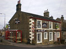 The Holywell Inn
Religion
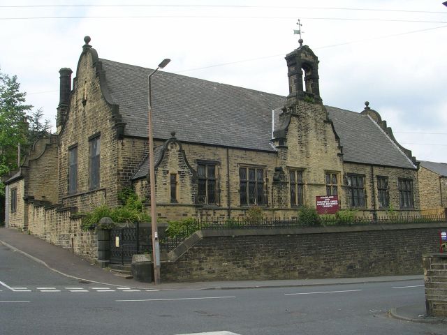
Located between Chapel Close and Stainland Road is Stainland and Holywell Green United Reformed Church. To the north of the church there are some fairly new houses, and another church used to stand here until it was demolished in the 1970s.
Community
Nisa Local, the shop, is on the junction of Stainland Road and Chapel Street. The launderette is next door to the shop. There is a fish and chip shop named James Street Fisheries on the Stainland Road and James Street junction.
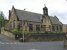 Stainland and Holywell Green United Reformed Church
Industry
Located on Burrwood Way are two industrial parks; Burrwood Industrial Estate and Springwood Business Park.
Below Shaw Park, in the valley, are two chemical plants. One is Stainland Works, accessible via the former route of the train line from Burrwood Way, and Rhodia Chemical Plant which is accessible via Brook Drive. Stainland Works is partly built on the site where Stainland and Holywell Green railway station used to be.
During the 19th century, there was a huge amount of industry in the valleys. Where Stainland Works is now is where Brookroyd Mills used to stand. By 1857, over 1,200 people worked here. Many of the houses in the village were built for the mill workers. Approaching Holywell Green from West Vale is the looming Burrwood Mill, now converted into apartments and known as Burrwood Court.
Education
Holywell Green has one school named Holywell Green Primary School. It also has a nursery.
References
External links
Categories:- Villages in West Yorkshire
- Geography of Calderdale


Wikimedia Foundation. 2010.