Craigavon Area Hospital

Craigavon Area Hospital
Southern Health and Social Care Trust
Geography
Location Lisnisky, Craigavon, Northern Ireland,
United Kingdom
Organisation
Care system NHS
Hospital type District General
Services
Emergency department Yes
History
Founded 1972
Links
Website [1]
Lists

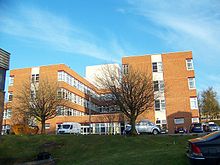
Craigavon Area Hospital is a large hospital in Craigavon, County Armagh, Northern Ireland. It serves an estimated 241,000 people from the boroughs/districts of Craigavon, Banbridge, Armagh and Dungannon–South Tyrone. It is within the townland of Lisnisky, beside the A3 road, at the edge of Portadown.

History

The hospital opened in 1972, as a foresight of the demands of the Craigavon new town, replacing Carleton House, Lurgan Hospital, Banbridge Hospital amongst others as the main acute centre in the region. Until the 2006 reform of the Northern Ireland Health and Social Care trusts, the hospital was the main centre of the Craigavon and Banbridge Health and Social Care Trust, which was amalgamated with several other trusts to form the Southern Health and Social Care Trust.

References

Coordinates: 54°26′06″N 6°24′37″W / 54.4349°N 6.4103°W / 54.4349; -6.4103


Wikimedia Foundation. 2010.

Игры ⚽ Нужна курсовая?

Look at other dictionaries:

  • Craigavon — Coordinates: 54°26′50″N 6°23′18″W / 54.447222°N 6.388333°W / 54.447222; 6.388333 …   Wikipedia

  • Daisy Hill Hospital — Newry and Mourne HSS Trust Geography Location Newry, Northern Ireland, United Kingdom Organisation Care system Public …   Wikipedia

  • Tyrone County Hospital — ( ga. Otharlann Contae Thír Eoghain) is the main hospital in Omagh, County Tyrone, Northern Ireland. The hospital has occupied the same site in the town since 1899. Proposed closureAs of 2006, the hospital is facing closure. The Maternity,… …   Wikipedia

  • Lagan Valley Hospital — Infobox Hospital Name = Lagan Valley Hospital Org/Group = South Eastern Health and Social Care Trust Caption = Location = Lisburn, Region = County Antrim State = Northern Ireland Country = United Kingdom HealthCare = NHS Type = District General… …   Wikipedia

  • Portadown — Infobox UK place official name= Portadown irish name= Port an Dúnáin scots name= Portadoun local name= static static image caption= map type= Northern Ireland latitude= 54.421027 longitude= 6.458244 belfast distance= 22 miles population= 30,000… …   Wikipedia

  • List of hospitals in Northern Ireland — The following is a partial list of currently operating hospitals in Northern Ireland.County AntrimBelfast*Alexandra Gardens Day Hospital *Belfast City Hospital *Cancer Centre, Belfast *Forster Green Hospital *Mater Infirmorum Hospital *Musgrave… …   Wikipedia

  • Chronology of Provisional Irish Republican Army actions (1970-1979) — This is a chronology of activities by the Provisional Irish Republican Army (IRA) from 1970 to 1979. For actions after this period see Chronology of Provisional Irish Republican Army actions. Incidents resulting in at least three deaths are… …   Wikipedia

  • Belfast Blitz — The Belfast Blitz was an event that occurred on the night of Easter Tuesday, 15 April 1941. Two hundred bombers of the German Air Force ( Luftwaffe ) attacked the city of Belfast in Northern Ireland. One thousand people died as a result of the… …   Wikipedia

  • Chronology of Provisional Irish Republican Army actions (1980-1989) — This is a chronology of activities by the Provisional Irish Republican Army (IRA) from 1980 to 1989. For actions before and after this period see Chronology of Provisional Irish Republican Army actions. Incidents resulting in at least three… …   Wikipedia

  • Free Derry — (lga|Saor Doire|no translate=yes) was a self declared autonomous nationalist area of Derry, Northern Ireland, between 1969 and 1972. Its name was taken from a sign painted on a gable wall in the Bogside in January 1969 which read, “You are now… …   Wikipedia

Share the article and excerpts

Direct link
Do a right-click on the link above
and select “Copy Link”