- Motya
-
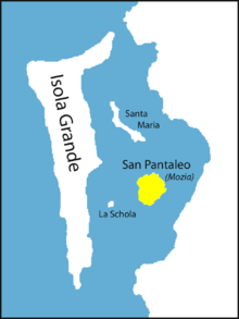
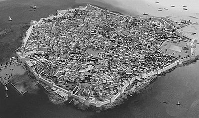
Motya (Greek: Μοτύη, Μοτύα; Italian: Mozia ot Mothia; Sicilian: Mozzia), was an ancient and powerful city on an island off the west coast of Sicily, between Drepanum (modern Trapani) and Lilybaeum (modern Marsala). The eponymous (in ancient times) island renamed San Pantaleo in the 11th century by Basilian monks is situated in a lagoon on the most western part of Sicily (nearly 850 metres long and 750 metres wide) about one km (six stadia) from the mainland of Sicily, to which it was joined by an artificial causeway (paved road), by which chariots with large wheels could reach the town.[1]
Contents
History
The foundation of the city probably dates from the 8th century BCE, about a century after the foundation of Carthage in Tunisia. It was originally a colony of the Phoenicians, who were fond of choosing similar sites, and probably in the first instance merely a commercial station or emporium, but gradually rose to be a flourishing and important town. The Greeks, however, according to their custom, assigned it a legendary origin, and derived its name from a woman named "Motya", whom they connected with the fables concerning Herakles.[2] According to coin finds the name "Motya" is derived from Phoenician "Mtw" and is said to mean "wool-spinning center". It passed, in common with the other Phoenician settlements in Sicily, at a later period under the government or dependency of Carthage, whence Diodorus calls it a Carthaginian colony; but it is probable that this is not strictly correct. [3] As the Greek colonies in Sicily increased in numbers and importance the Phoenicians gradually abandoned their settlements in the immediate neighbourhood of the newcomers, and concentrated themselves in the three principal colonies of Solus, Panormus (modern Palermo), and Motya. [4] The last of these, from its proximity to Carthage and its opportune situation for communication with Africa, as well as the natural strength of its position, became one of the chief strongholds of the Carthaginians, as well as one of the most important of their commercial cities in the island.[5] It appears to have held, in both these respects, the same position which was attained at a later period by Lilybaeum.
Notwithstanding these accounts of its early importance and flourishing condition, the name of Motya is rarely mentioned in history until just before the period of its memorable siege. It is first mentioned by Hecataeus, [6] and Thucydides notices it among the chief colonies of the Phoenicians in Sicily, which still subsisted at the period of the Athenian expedition, 415 BCE.[7] A few years later (409 BCE) when the Carthaginian army under Hannibal Mago landed at the promontory of Lilybaeum, that general laid up his fleet for security in the gulf around Motya, while he advanced with his land forces along the coast to attack Selinus.[8] After the fall of the latter city, we are told that Hermocrates, the Syracusan exile, who had established himself on its ruins with a numerous band of followers, laid waste the territories of Motya and Panormus;[9] and again during the second expedition of the Carthaginians under Hamilcar (407 BCE), these two cities became the permanent station of the Carthaginian fleet.[10]
It was the important position to which Motya had thus attained that led Dionysius I of Syracuse to direct his principal efforts to its reduction, when in 397 BCE he in his turn invaded the Carthaginian territory in Sicily. The citizens on the other hand, relying on succour from Carthage, made preparations for a vigorous resistance; and by cutting off the causeway which united them to the mainland, compelled Dionysius to have recourse to the tedious and laborious process of constructing a mound or mole of earth across the intervening space. Even when this was accomplished, and the military engines of Dionysius (among which the formidable catapult on this occasion made its appearance for the first time) were brought up to the walls, the Motyans continued a desperate resistance; and after the walls and towers were carried by the overwhelming forces of the enemy, still maintained the defence from street to street and from house to house. This obstinate struggle only increased the previous exasperation of the Sicilian Greeks against the Carthaginians; and when at length the troops of Dionysius made themselves masters of the city, they put the whole surviving population, men, women, and children, to the sword.[11] After this the Syracusan despot placed it in charge of a garrison under an officer named Biton; while his brother Leptines made it the station of his fleet. But the next spring (396 BCE) Himilcon, the Carthaginian general, having landed at Panormus with a very large force, recovered possession of Motya with comparatively little difficulty.[12] Motya, however, was not destined to recover its former importance; for Himilcon, being apparently struck with the superior advantages of Lilybaeum, founded a new city on the promontory of that name, to which he transferred the few remaining inhabitants of Motya.[13] From this period the latter altogether disappears from history; and the little islet on which it was built, has probably ever since, as now, been inhabited only by a few fishermen. By the time the Romans conquered Sicily, during the First Punic War (264–241 BCE), Motya had been eclipsed by Lilybaeum. Image:Mozia,_cothon.jpg|
It is a singular fact that, though we have no account of Motya having received any Greek population, or fallen into the hands of the Greeks before its conquest by Dionysius, there exist coins of the city with the Greek legend "ΜΟΤΥΑΙΟΝ". They are, however, of great rarity, and are apparently imitated from those of the neighboring city of Segesta.[14]
Current situation
The site of Motya, on which earlier geographers were in much doubt, has been clearly identified and described by William Henry Smyth. Between the promontory of Lilybaeum (Capo Boéo) and that of Aegithallus (San Teodoro), the coast forms a deep bight, in front of which lies a long group of low rocky islets, called the Stagnone. Within these, and considerably nearer to the mainland, lies the small island formerly called San Pantaleo, on which the remains of an ancient city may still be distinctly traced. Fragments of the walls,, with those of two gateways, still exist, and coins as well as pieces of ancient brick and pottery – the never failing indications of an ancient site – were found scattered throughout the island. The circuit of the latter does not exceed 2.5 km, and it is inhabited only by a few fishermen; but is not devoid of fertility.[15] The confined space on which the city was built agrees with the description of Diodorus that the houses were lofty and of solid construction, with narrow streets (στενωποί) between them, which facilitated the desperate defence of the inhabitants.[16]
-
Ephebos at the Motya museum
Archaeology
In March 2006, archaeological digs uncovered rooms of a previously undiscovered house at one of the town's siege walls. The finds have shown that the town had a "thriving population long after it is commonly believed to have been destroyed by the Ancient Greeks." Discovered items include cooking pans, Phoenician-style vases, altars, and looms. [17]
In Modern Fiction
The 399 BC Battle of Motya, part of the war of Syracuse's Syracuse's tyrant Dionysios I against Carthage is a major event in the 1965 historical novel "The Arrows of Hercules" by L. Sprague de Camp.
References
- ^ Diodorus xiv. 48.
- ^ Stephanus of Byzantium s. v.
- ^ Thucydides vi. 2 ; Diod. xiv. 47.
- ^ Thuc. l. c.
- ^ Diod. xiv. 47.
- ^ ap. Steph. B. s. v..
- ^ Thuc. vi. 2.
- ^ Diod. xiii. 54, 61.
- ^ Id. xiii. 63.
- ^ Id. xiii. 88.
- ^ Diod. xiv. 47-53.
- ^ Ibid. 55.
- ^ Diod. xxii. 10. p. 498.
- ^ Eckhel, vol. i. p. 225.
- ^ William Henry Smyth, Sicily, pp. 235, 236.
- ^ Diod. xiv. 48, 51.
- ^ [1]
 This article incorporates text from a publication now in the public domain: Smith, William, ed (1854–57). "article name needed". Dictionary of Greek and Roman Geography. London: John Murray.
External links
- Archaeological expedition to Motya, by Sapienza University of Rome
- Livius Picture Archive, including maps of the island and the lagoon
- picture archive
Coordinates: 37°52′06″N 12°28′07″E / 37.86833°N 12.46861°E
Wikimedia Foundation. 2010.


