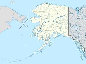
- Chatanika, Alaska
-
Chatanika, Alaska Location of Chatanika in the U.S. state of Alaska Coordinates (USGS GNIS 1400167): 65°6′44″N 147°28′38″W / 65.11222°N 147.47722°WCoordinates: 65°6′44″N 147°28′38″W / 65.11222°N 147.47722°W Country United States State Alaska Borough Fairbanks North Star Township T N R W Meridian Settled Named for Chatanika River Elevation[1] 896 ft (273 m) Time zone Alaska (AKST) (UTC-9) - Summer (DST) AKDT (UTC-8) Zipcode Area code 907 FIPS code 02-12460 GNIS feature ID 1400167 Chatanika is an unincorporated community in Fairbanks North Star Borough, Alaska, United States, near Fairbanks. It was one of many communities whose prosperity was tied to gold mining and railroad operations.
Contents
History
A mining settlement established about 1904, it received a railroad station when the Tanana Valley Railroad was completed in 1907. The Chatanika post office was established in 1908.[1]
Etymology
The community was named after the Chatanika River.[1]
Geography
Located 2 miles (3.2 km) east of the confluence of Cleary Creek and the Chatanika River, Chatanika lies 20 miles (32 km) northeast of Fairbanks. Its altitude is 896 feet (273 m).[1]
Gold dredge
The Chatanika gold dredge is a historic relic of gold dredge #3 owned and operated by F.E. Company between 1928 and 1958. The dredge is located at about 27.5 metres (90 ft) along the Steese Highway east of Fairbanks in a 60 acres (24 ha) pond it dug itself, directly across the road from the Chatanika Lodge] Today the dredge is private property and off-limits to the public.[2]
References
Municipalities and communities of Fairbanks North Star Borough, Alaska Cities CDPs College | Eielson AFB | Ester | Fox | Harding-Birch Lakes | Moose Creek | Pleasant Valley | Salcha | Two Rivers
Unincorporated
communitiesChatanika | Chena Hot Springs
Categories:- Unincorporated communities in Alaska
- Populated places in Fairbanks North Star Borough, Alaska
Wikimedia Foundation. 2010.


