Davol Square

Davol Square
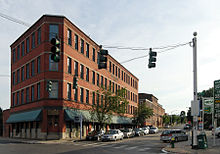
Corner of Eddy and Point Streets, looking west
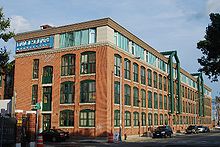
former Davol Rubber Company at Davol Square

Davol Square is a historic public square in central Providence, Rhode Island. It is located at the intersection of Point Street and Eddy Street in the Upper South Providence neighborhood, in the middle of the Jewelry District.

Description

The historic Davol Rubber Company building and the former South Street Station of Narragansett Electric are located on the northeast corner of the square along Eddy Street. In 2004, the historic J.G. Goff's pub building (ca. 1820), located at the foot of the Point Street Bridge was demolished after its foundation was severely damaged during the construction of the Narragansett Bay Commission's combined sewer overflow project.[1] The Manchester Street Power Plant is located at the southeast corner of the intersection, with its triple-stacks visible from many parts of the city.

As a consequence of efforts by the Rhode Island Economic Policy Council some high-tech firms are beginning to establish themselves in the area.[2] The power plant building, donated by Narragansett Electric Co., will be the site of the Heritage Harbor Museum.[3]

Brown University announced intentions to purchase a number of buildings in the area as part of its expansion.[4]

See also

References


Wikimedia Foundation. 2010.

Игры ⚽ Нужно сделать НИР?

Look at other dictionaries:

  • Davol Rubber Company — U.S. National Register of Historic Places …   Wikipedia

  • Jewelry District, Providence, Rhode Island — The Jewelry District is a neighborhood of Providence, Rhode Island located just south of Downtown between Interstate 195 and Henderson Street. Interstate 95 lies at the western edge of the neighborhood, which includes Davol Square and the… …   Wikipedia

  • Neighborhoods in Providence — The city of Providence, Rhode Island has 25 official neighborhoods. [cite web | url=http://www.providenceri.com/Neighborhoods/NeighborhoodMap c.html |publisher=City of Providence | title=Providence Neighborhoods|accessdate = 2007 01 17] *… …   Wikipedia

  • Neighborhoods in Providence, Rhode Island — Providence neighborhoods with major highways shown …   Wikipedia

  • National Register of Historic Places listings in Providence, Rhode Island — Location of Providence in Rhode Island This is a list of the National Register of Historic Places listings in Providence, Rhode Island. This is intended to be a complete list of the properties and districts on the National Register of Historic… …   Wikipedia

  • Labrador Retriever coat colour genetics — The genetic basis of coat colour in the Labrador Retriever (a highly popular type of dog) has been widely studied, and found to depend on many genes. A wide range of colourings have developed over time.This article examines the current knowledge… …   Wikipedia

  • Rhode Island — Rhode Islander. /rohd/ a state of the NE United States, on the Atlantic coast: a part of New England. 947,154; 1214 sq. mi. (3145 sq. km). Cap.: Providence. Abbr.: RI (for use with zip code), R.I. * * * officially Rhode Island and Providence… …   Universalium

Share the article and excerpts

Direct link
Do a right-click on the link above
and select “Copy Link”