Miass River

Miass River
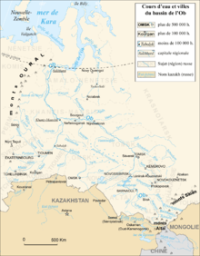
Miass River at the southwest corner of the Ob Basin (double click to expand)

Miass River (Russian: Миасс, Bashkir: Мейәс) is a river on the eastern side of the Ural Mountains near Chelyabinsk. It flows mainly northeast to join the Iset River which continues northeast to join the north-flowing Tobol River which leads to the Ob River and the Arctic Ocean. Located mostly in Chelyabinsk Oblast and Kurgan Oblast, its length is 658 km and the area of its basin 21,800 km². The Miass River freezes up in late October–November and stays under the ice until April. The cities of Chelyabinsk and Miass are located on the Miass River.

Its headwaters are in the northeast corner of Bashkiria near those of the east-flowing Uy River, the south-flowing Ural River and the Ufa River and Belaya River, both of which lead west to the Volga. It flows about 50 km north past the town of Miass to the Argazi Reservoir, then mostly east to Chelyabinsk and then mostly northeast to meet the Iset River. South of the Miass is the Uy River which flows east to the Tobol and northwest, the Techa River which also flows northeast into the Iset.

Coordinates: 56°05′44″N 64°29′56″E / 56.0956°N 64.4989°E / 56.0956; 64.4989


Wikimedia Foundation. 2010.

Игры ⚽ Нужен реферат?

Look at other dictionaries:

  • Miass — This article is about the city. For the eponymous river, see Miass River. Miass (English) Миасс (Russian) …   Wikipedia

  • Miass — /mee ahs /; Russ. /myi ahs /, n. a city in the S Russian Federation in Asia, near the Ural Mountains, W of Chelyabinsk. 150,000. * * * ▪ Russia       city, Chelyabinsk oblast (region), west central Russia, on the Miass River. Miass was founded in …   Universalium

  • Río Miass — Saltar a navegación, búsqueda Río Miass (Река Миасс) …   Wikipedia Español

  • Iset River — Infobox River river name = Iset caption = Iset River in Yekaterinburg origin = Isetskoye Lake mouth = Tobol River basin countries = Russia length = 606 km elevation = discharge = 105 km from mouth: 65.4 m³/s watershed = 58 900 km²Iset River ( ru …   Wikipedia

  • Argazi Reservoir — Infobox lake lake name = Argazi Reservoir image lake = caption lake = image bathymetry = caption bathymetry = location = Chelyabinsk Oblast coords = type = reservoir inflow = Miass River outflow = Miass River catchment = basin countries = Russia… …   Wikipedia

  • Chelyabinsk — Not to be confused with Chelyabinsk 40 or Chelyabinsk 65. Chelyabinsk (English) Челябинск (Russian) …   Wikipedia

  • Chelyabinsk Trade Center — (Russian: Челябинский Торговый центр) is a building on the embankment of the Miass River in Chelyabinsk, Russia, built in 1975. The Trade Center silhouette became one of the symbols of the city. The main square building (side size is 102 meters)… …   Wikipedia

  • Миасс (река) — У этого термина существуют и другие значения, см. Миасс (значения). Миасс Характеристика …   Википедия

  • Chelyabinsk — /chel yah binsk/; Russ. /chyi lyah byinsk/, n. a city in the S Russian Federation in Asia, E of the the Ural Mountains. 1,143,000. * * * City (pop., 2001 est.: 1,081,800), western Russia. Located 125 mi (200 km) south of Yekaterinburg on the… …   Universalium

  • List of rivers of Russia — Russia can be divided into a European and an Asian part. The dividing line is generally considered to be the Ural Mountains and the Caspian Sea. The European part is drained into the Arctic Ocean, Baltic Sea, Black Sea and Caspian Sea. The Asian… …   Wikipedia

Share the article and excerpts

Direct link
Do a right-click on the link above
and select “Copy Link”