- Nehalim
-
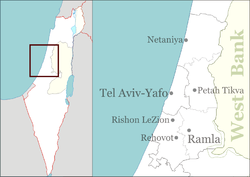
Nehalim Founded 1952 Founded by Jerusalem Organisation members Council Hevel Modi'in Region Central Israel Affiliation Hapoel HaMizrachi Coordinates 32°3′30.6″N 34°54′49.31″E / 32.0585°N 34.9136972°ECoordinates: 32°3′30.6″N 34°54′49.31″E / 32.0585°N 34.9136972°E Nehalim (Hebrew: נְחָלִים, lit. Streams) is a religious moshav in central Israel. Located around four kilometres east of Petah Tikva, it falls under the jurisdiction of Hevel Modi'in Regional Council. In 2007 it had a population of 2,100.
The moshav was established by members of the Jerusalem Organisation. They had begun agricultural training in 1938 in Menahemia. In 1944 they moved to the Finger of the Galilee and settled in an area which is today HaGoshrim. It was named after the nearby streams running to the River Jordan. As a result of the 1948 Arab-Israeli War, the religious residents agreed to leave (the settlement was now on the border with Syria), and moved to houses in the abandoned village of Wilhelma. The new moshav was founded in 1952 on 25 dunams of land.
Kibbutzim Moshavim Ahisamakh · Bareket · Beit Arif · Beit Nehemia · Ben Shemen · Bnei Atarot · Ginaton · Gimzo · Givat Koah · Hadid · Kerem Ben Shemen · Kfar Daniel · Kfar Rut · Kfar Truman · Mazor · Nehalim · Rinatia · Shilat · Tirat YehudaCommunal settlements Youth villages Categories:- Hevel Modi'in Regional Council
- Moshavim
- Religious Israeli communities
- Populated places established in 1952
- Jewish villages depopulated during the 1948 Arab–Israeli War
Wikimedia Foundation. 2010.

