- 1989 Pacific hurricane season
Infobox hurricane season
Basin=EPac
Year=1989
Track=1989 Pacific hurricane season map.png
Last storm dissipated=October 19, 1989
Strongest storm name=Raymond
Strongest storm winds=125
Strongest storm pressure=935
Average wind speed=1
Total depressions=24
Total storms=17
Total hurricanes=9
Total intense=4
Fatalities=at least 30
Da
Inflated=1
five seasons=1987, 1988, 1989, 1990, 1991Pacific Ocean .Notable storms include Hurricanes Cosme, Kiko, and Raymond. Cosme crossed over Mexico and contributed to the formation of Tropical Storm Allison in the Atlantic. Hurricane Kiko made landfall on the
Gulf of California side of theBaja California Peninsula . Hurricane Raymond was the strongest storm of the season, but weakened significantly before landfall.__TOC__
eason summary
Overall, the season continued the general trend in the 1980s of near to above-average seasons in the East Pacific. Seventeen cyclones formed. Eight peaked at tropical storm strength. Nine systems became hurricanes, of which four were major hurricanes at Category 3 intensity or higher on the
Saffir-Simpson Hurricane Scale .On August 28, three systems were active, one of a few times when there has been three tropical cyclones active simultaneously in the east Pacific. The systems were Kiko, Lorena, and the pre-Manuel tropical depression.
Despite the activity this season, no named storms formed in October. This was the second consecutive season this happened.
Tropical Storm Adolph
Infobox Hurricane Small
Basin=EPac
Track=Adolph 1989 track.png
Dissipated=June 5
1-min winds=55
Pressure=994Hurricane Barbara
Infobox Hurricane Small
Basin=EPac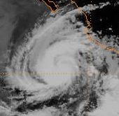
Track=Barbara 1989 track.png
Dissipated=June 20
1-min winds=70
Pressure=984Hurricane Cosme
Infobox Hurricane Small
Basin=EPac
Track=Cosme 1989 track.png
Dissipated=June 23
1-min winds=75
Pressure=979Acapulco that had spent two days badly organized. It strengthened into a tropical storm June 19. After spending two days nearly motionless, it turned to the north and accelerated. Cosme reached Category 1 intensity on the morning of June 21. It made landfall east of Acapulco late on June 21. It quickly weakened, and all that remained was a swirl of clouds on June 23.Cosme's remnants merged with a tropical wave and contributed to the formation of Tropical Storm Allison in the
Gulf of Mexico . As Cosme had dissipated and merged with another disturbance, it is not entirely clear whether Allison was a direct continuation of Cosme or not.Cosme brought heavy rains, which killed at least 30 people due to drowning. Many
adobe homes were destroyed, but a specific cost of damage is not known.ref|NHCCosmeTropical Depression Four-E
Infobox Hurricane Small
Basin=EPac
Formed=July 9
Dissipated=July 13
1-min winds=30Tropical Depression Four-E developed in east of the CPHC's area of responsibility on July 9. On July 11 it crossed into the central Pacific and remained a depression until it dissipated south ofSouth Point, Hawaii .Tropical Depression Five-E
Infobox Hurricane Small
Basin=EPac
Formed=July 10
Dissipated=July 16
1-min winds=30This system formed slightly behind Four-E and moved into the central Pacific on July 14.Hurricane Dalilia
Infobox Hurricane Small
Basin=EPac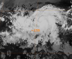
Track=Dalilia 1989 track.png
Dissipated=July 21
1-min winds=80
Pressure=977ITCZ . Convection increased, which suppressed the ITCZ nearby. The disturbance developed into Tropical Depression Six-E on the morning of July 11.The depression intensified quickly, reaching storm strength one July 12 and a hurricane 24 hours later. Dalilia crossed 140°W near maximum intensity and entered the
Central Pacific Hurricane Center 's area of responsibility. The storm accelerated to a velocity of 20 knots, headed directly towards theHawaiian Islands . Dalilia passed just south of the Hawaiian Islands as a tropical storm before dissipating July 21 as it interacted with a cold trough.Dalilia's remnants passed over the Northwestern Hawaiian Islands. They interacted with the remains of Tropical Storm Erick and reformed into a depression on July 24. The depression passed close to
Midway Island , where it may have briefly become a storm again. Dalilia's dissipation, part two, occurred on July 25. A trough then accelerated the remnants towards theAleutian Islands on July 28.ref|CPHCDaliliaDalilia's effects were minimal. There was high surf, and some gusty winds. Damage was minor, and mainly limited to downed power lines. Rains were heavy, including a record amount at
Honolulu International Airport . OnKauai , interaction with the cold trough caused localized flooding severe enough to causeemergency evacuation s from theWainiha Valley . Dalilia's remains produced heavy rain on the northwestern Hawaiian Islands, especiallyFrench Frigate Shoals .ref|NHCDaliliaTropical Depression Seven-E
Infobox Hurricane Small
Basin=EPac
Formed=July 16
Dissipated=July 18
1-min winds=30Post-analysis indicated this system likely became Tropical Depression Eight-E, and later Tropical Storm Erick.ref|NHCTDsFormErickTropical Storm Erick
Infobox Hurricane Small
Basin=EPac
Track=Erick 1989 track.png
Dissipated=July 21
1-min winds=35
Pressure=1005Tropical Storm Flossie
Infobox Hurricane Small
Basin=EPac
Track=Flossie 1989 track.png
Dissipated=July 28
1-min winds=35
Pressure=1004The new center, which remarkably stayed a tropical storm, drifted northwest. Flossie then encountered an unfavourable environment, and dropped to a depression on July 25. Tropical Depression Flossie continued drifting to the northwest until dissipating July 28 while just off the coast of the
Baja California Peninsula . Flossie had no effect on land.ref|NHCFlossieHurricane Gil
Infobox Hurricane Small
Basin=EPac
Track=Gil 1989 track.png
Dissipated=August 5
1-min winds=75
Pressure=979Mexico -Guatemala border developed a circulation in theGulf of Tehuantepec and then dissipated. On July 30, the disturbance redeveloped a circulation and then convection. It paralleled the coast of Mexico and headed in a northwesterly direction. It strengthened into a tropical storm on July 31 and a hurricane that same day. Gil was a hurricane for only about 30 hours, and it weakened into a storm on August 2 and a depression the next day. The cyclone dissipated on August 5.Gil was a very rainy storm, and satellite data indicated that heavy rainfall fell on mountainous portions of Mexico. It is possible that there were deaths or damage from flash-flooding, but this is not known. Gil also caused heavy rain but minimal wind on
Socorro Island .ref|NHCGilTropical Storm Henriette
Infobox Hurricane Small
Basin=EPac
Track=Henriette 1989 track.png
Dissipated=August 17
1-min winds=45
Pressure=1000Hurricane Ismael
Infobox Hurricane Small
Basin=EPac
Track=Ismael 1989 track.png
Dissipated=August 25
1-min winds=105
Pressure=955On August 21, Ismael passed over cooler waters and encountered wind shear. The hostile environment took its toll on Ismael, and it weakened to a tropical storm on August 23. Ismael dissipated not long after weakening to a depression on August 25.
During the early stages of its life, Ismael dumped heavy rains in the area around
Acapulco . Flash-flooding and landslides were reported, but fortunately there were no casualties or damage.ref|NHCIsmaelTropical Storm Juliette
Infobox Hurricane Small
Basin=EPac
Track=Juliette 1989 track.png
Dissipated=August 25
1-min winds=55
Pressure=992Hurricane Kiko
Infobox Hurricane Small
Basin=EPac.jpg)
Track=Kiko 1989 track.png
Dissipated=August 29
1-min winds=105
Pressure=955Mesoscale Convective System " over centralMexico entered the Pacific Ocean on August 24. Over the next day, a circulation developed, and the disturbance developed into Tropical Depression Fourteen-E on August 25. Intensification was rapid, and it became a tropical storm late that same day. The quick strengthening continued, and Kiko peaked with winds at 105 knots just off the southern tip of theBaja California Peninsula . Kiko made landfall on the eastern shore ofBaja California Sur on the morning of August 27. Due to its small size and slow motion, Kiko weakened rapidly. It was a depression when it crossed into the open ocean on August 28. At that point, it started interacting with then Tropical Storm Lorena, and dissipated August 29. Kiko's remnants were eventually absorbed by Lorena.Kiko is one of the most intense hurricanes to make landfall on the eastern side of the
Baja California Peninsula . It was one of 2 major hurricanes to hit here; the other was Hurricane Olivia in 1967,but Olivia was slightly stronger (125 mph winds).ref|NHCKiko The hurricane dropped up to 6 inches of rainfall in Todos Santos [http://www.ern.com.mx/Huracan/ERN-031201-H01B.pdf] and caused a 5 foot storm surge in Ensenada. Kiko produced strong winds of up to 110 mph (180 km/h) inCabo San Lucas , causing severe damage throughout the southern tip of Baja California. [http://www.coscyt.edu.mx/tesis_en_pdf/m_en_eleonora_romero_vadillo.pdf]Hurricane Lorena
Infobox Hurricane Small
Basin=EPac
Track=Lorena 1989 track.png
Dissipated=September 6
1-min winds=65
Pressure=989tropical wave spawned Tropical Depression Six. Twenty four hours later,wind shear degenerated the depression back into a wave. The wave continued westward, and in the southernCaribbean Sea , split in two on August 21. The southern part crossedCentral America and emerged into the Pacific Ocean. Banding and convection steadily organized, and Tropical Depression Fifteen-E formed on August 27. It strengthened into Tropical Storm Lorena the next day.ref|NHCLorenaTDAt this time, three systems were active and in close proximity. Lorena and a weakened Kiko started a
Fujiwhara interaction . Lorena emerged victorious in the three-way battle for dominance, and absorbed Kiko's remnants on August 29.Moving slowly out to sea, Lorena reached minimal hurricane strength on the first day of September. Lorena was a hurricane for less than a day. It weakened quickly falling to a depression on September 3. The cyclone was empty of convection by September 7.ref|NHCLorena
Tropical Storm Manuel
Infobox Hurricane Small
Basin=EPac
Track=Manuel 1989 track.png
Dissipated=August 31
1-min winds=40
Pressure=1002Manuel's only impact on land was to produce light rainfall in the vicinity of
Manzanillo, Colima . No reports of death or damage were received by theNational Hurricane Center .ref|NHCManuelTropical Storm Narda
Infobox Hurricane Small
Basin=EPac
Track=Narda 1989 track.png
Dissipated=September 7
1-min winds=45
Pressure=1000Narda produced breezes on
Socorro Island , but otherwise had no impact on land. There were no casualties or damage.ref|NHCNardaHurricane Octave
Infobox Hurricane Small
Basin=EPac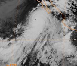
Track=Octave 1989 track.png
Dissipated=September 16
1-min winds=115
Pressure=948The cyclone turned northwestward, and strengthened into Tropical Storm Octave on September 10. After strengthening into a hurricane the next day, Octave started deepening. After peaking as a Category 4 on September 13 with 135 mph winds, Octave moved into a region of cooler waters and strong shear. Octave weakened to a storm at midday on September 14 and a depression 32 hours later. The depression hooked to the east, and dissipated on September 18 near
Guadalupe Island . The remnants eventually turned to the north before dissipating.While Octave had no significant effects on land as a hurricane, its remnants did move into
California . Effects were limited to minor damage to thegrape andraisin crops.ref|NHCOctaveTropical Storm Priscilla
Infobox Hurricane Small
Basin=EPac
Track=Priscilla 1989 track.png
Dissipated=September 25
1-min winds=55
Pressure=993Priscilla formed close to land but moved away from it without impact. No reports of deaths or damage were received by the NHC.ref|NHCPriscilla
Tropical Depression Twenty-E
Infobox Hurricane Small
Basin=EPac
Formed=September 25
Dissipated=September 27
1-min winds=30This system formed southwest ofGuatemala a moved very little until it dissipated on September 27.Hurricane Raymond
Infobox Hurricane Small
Basin=EPac.jpg)
Track=Raymond 1989 track.png
Dissipated=October 5
1-min winds=125
Pressure=935tropical wave that had earlier spawnedHurricane Hugo . Moving slowly to the west-northwest, it accelerated to the northwest in response to a trough and strengthened into the seventeenth named storm of the season on September 26. Raymond turned to the west again and entered a favourable environment. Raymond eventually peaked as a Category 4 hurricane and the strongest storm of the season on October 1.A trough over Mexico destroyed the ridge that was steering Raymond and recurved the cyclone to the northeast. The hurricane accelerated into a less favorable environment, and slowly weakened as its forward speed increased to 20 knots. Raymond made landfall as a tropical storm on October 4. Northern Mexico's mountains disrupted Raymond's circulation, and dissipated over New Mexico on October 5 after passing over that state and
Arizona as a depression. The upper level portion of its circulation whisked eastward across the southern Plains and Mid-Mississippi Valley, spreading light to moderate rains near its path.ref|RaymondRainfallRaymond's impact in Mexico is not known. Flash-flooding in southeast
Arizona caused 1.5 million dollars in damage.ref|NHCRaymondTropical Depression Twenty Two-E
Infobox Hurricane Small
Basin=EPac
Formed=October 3
Dissipated=October 8
1-min winds=30This system formed 475 miles south ofCape Corrientes and dissipated on October 4. However, it regenerated on the 7th, but dissipated again on October 8.Tropical Depression Twenty Three-E
Infobox Hurricane Small
Basin=EPac
Formed=October 15
Dissipated=October 17
1-min winds=30This system formed south of the coast ofJalisco and became unidentifiable on October 17.Tropical Depression Twenty Four-E
Infobox Hurricane Small
Basin=EPac
Formed=October 18
Dissipated=October 19
1-min winds=30This was a short-lived system that existed far from land. Convection was dampened early by strong shear.1989 storm names
The following names were used for named storms that formed in the eastern Pacific in 1989. No names were retired, so it was used again in the 1995 season. This is the same list used for the 1983 season, except for the names X, Y, and Z names, which were added to eastern Pacific lists starting in 1985. No central Pacific names were used; the first name used would have been Aka. Names that were not assigned are marked in gray.
This is the last time Dalilia would be used; an error in documents before the 1995 season introduced the misspelling of "Dalila", which has remained.ref|DaliliaMispelling
ee also
*
List of Pacific hurricanes
*List of Pacific hurricane seasons
*1989 Atlantic hurricane season
*1989 Pacific typhoon season
*1989 North Indian Ocean cyclone season
*Southern Hemisphere tropical cyclone seasons: 1988–89, 1989–90References
# [ftp://ftp.nhc.noaa.gov/pub/storm_archives/pacific/prelimep/ep1989/adolph/ NHC Adolph Report]
# [ftp://ftp.nhc.noaa.gov/pub/storm_archives/pacific/prelimep/ep1989/barbara/ NHC Barbara Report]
# [ftp://ftp.nhc.noaa.gov/pub/storm_archives/pacific/prelimep/ep1989/cosme/ NHC Cosme Report]
# [http://www.prh.noaa.gov/cphc/pages/hurrclimate.php#1989 Central Pacific Hurricane Center Dalilia Report]
# [ftp://ftp.nhc.noaa.gov/pub/storm_archives/pacific/prelimep/ep1989/dalilia/ NHC Dalilia Report]
# [ftp://ftp.nhc.noaa.gov/pub/storm_archives/pacific/prelimep/ep1989/erick/ NHC Erick Report]
# [ftp://ftp.nhc.noaa.gov/pub/storm_archives/pacific/prelimep/ep1989/flossie/prelim01.gifNHC Flossie Report]
# ibid.
# [ftp://ftp.nhc.noaa.gov/pub/storm_archives/pacific/prelimep/ep1989/gil/ NHC Gil Report]
# [ftp://ftp.nhc.noaa.gov/pub/storm_archives/pacific/prelimep/ep1989/henriett/ NHC Henriette Report]
# [ftp://ftp.nhc.noaa.gov/pub/storm_archives/pacific/prelimep/ep1989/ismael/ NHC Ismael Report]
# [ftp://ftp.nhc.noaa.gov/pub/storm_archives/pacific/prelimep/ep1989/juliette/ NHC Juliette Report]
# [ftp://ftp.nhc.noaa.gov/pub/storm_archives/pacific/prelimep/ep1989/kiko/ NHC Lorena Report]
# [ftp://ftp.nhc.noaa.gov/pub/storm_archives/pacific/prelimep/ep1989/lorena/ NHC Lorena Report]
# ibid.
# [ftp://ftp.nhc.noaa.gov/pub/storm_archives/pacific/prelimep/ep1989/manuel/ NHC Manuel Report]
# [ftp://ftp.nhc.noaa.gov/pub/storm_archives/pacific/prelimep/ep1989/narda/ NHC Narda Report]
# [ftp://ftp.nhc.noaa.gov/pub/storm_archives/pacific/prelimep/ep1989/octave/ NHC Octave Report]
# ibid.
# [ftp://ftp.nhc.noaa.gov/pub/storm_archives/pacific/prelimep/ep1989/priscill/ NHC Priscilla Report]
# [http://www.hpc.ncep.noaa.gov/tropical/rain/raymond1989rain.gifHPC Raymond Rainfall Map]
# [ftp://ftp.nhc.noaa.gov/pub/storm_archives/pacific/prelimep/ep1989/raymond/ NHC Raymond Report]
# [ftp://ftp.nhc.noaa.gov/pub/storm_archives/pacific/prelimep/ep1989/erick/prelim01.gifNHC Erick op. cit.]
# [http://www.nhc.noaa.gov/1995dalila.html NHC 1995 Dalilia Summary]External links
* [ftp://ftp.nhc.noaa.gov/pub/storm_archives/pacific/prelimep/ep1989/ NHC 1989 Pacific hurricane season archive]
* [http://www.prh.noaa.gov/cphc/pages/hurrclimate.php#1989 Central Pacific Hurricane Center archive]

Wikimedia Foundation. 2010.