- Buena Vista (Paraguay)
Infobox City
name = Buena Vista
motto
imagesize =
image_caption =
imagesize =
image_caption =
image_shield =Coat_of_arms_of_Paraguay.svg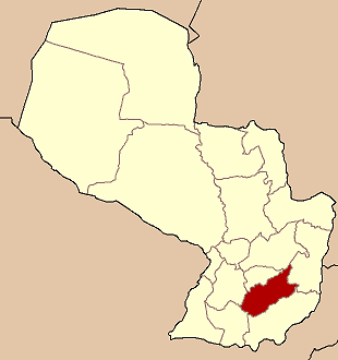
mapsize = 200px
map_caption =
subdivision_type = Country
subdivision_name =Paraguay
subdivision_type1 = Department
subdivision_name1 = Caazapá
leader_title = Intendente Municipal
leader_name = Estanislao Silvero (PLRA)
established_title = Founded
established_date =June 25th ,1945
area_magnitude =
area_total_sq_mi =
area_total_km2 = 126
area_land_sq_mi =
area_land_km2 =
area_water_sq_mi =
area_water_km2 =
area_water_percent =
area_urban_sq_mi =
area_urban_km2 =
area_metro_sq_mi =
area_metro_km2 =
population_as_of = 2008
population_note =
population_total = 5.340 inhab
population_metro =
population_urban =
population_density_km2 = 43
population_density_sq_mi =
timezone = -4 Gmt
utc_offset =
timezone_DST =
utc_offset_DST =
latd= 26 |latm= 10 |lats= 52 |latNS= S
longd= 56 |longm= 04 |longs= 59 |longEW= W
elevation_m = 138
elevation_ft =
postal_code_type = Postal code
postal_code = 5990
area_code =
website=City of
Paraguay ,Caazapa Region, the beginning of this city was the result of the new political division of the country onJune 25th ,1945 .Etymology
Its name describes the beautiful environment of the place.
Geography
Buena Vista is 266 km far from
Asunción. Weather
Temperatures range from 21ºC to 37ºC in summer, in winter the minimum is 1ºC. This city is located in one of the regions with most f the precipitations, that is the reason why it is the best place for farming and cattle rising.
Demography
There is a total of 5.340 inhabitants, 2.773 are men and 2.567 women, according to Census 2002. In the urban area there are 1.416 people and the rural area 3.924 people.
Economy
The main activity is farming and cattle rising.
Tourism
Wonderful landscapes which refer to the city´s name “Buena Vista” can be appreciated. Capiibary River is great for fishing.
How to get there
It is located 278 km far from
Asunción , between San Juan Nepomuceno andCaazapá From Asunción take Route N 2, “Mcal. José Félix Estigarribia” towards east. That route goes toCiudad del Este .Bibliography and references
* Geografía Ilustrada del Paraguay, Distribuidora Arami SRL; 2007. ISBN 99925-68-04-6
* Geografía del Paraguay, Primera Edición 1999, Editorial Hispana Paraguay SRL
* EVP - Wikipedia
* [http://www.evp.edu.py/index.php?title=Portada Enciclopedia Virtual Paraguaya - Portal]
Wikimedia Foundation. 2010.