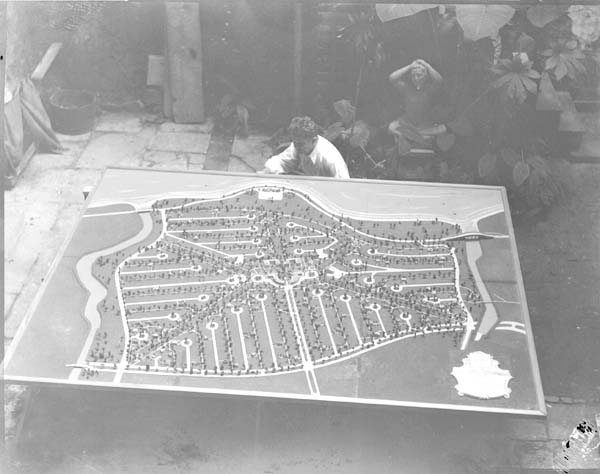
- Lakeshore/Lake Vista, New Orleans
Geobox Neighborhood
name = Lakeshore/Lake Vista
native_name =
other_name =
other_name1 =
category = New Orleans Neighborhood

image_caption = WPA relief map of Lake Vista, 1936
flag_size =
symbol =
symbol_size =
etymology_type =
etymology =
nickname =
motto =
country = United States
state = Louisiana
region_type = City
region = New Orleans
district_type = Planning District
district = District 5, Lakeview District
area_imperial = 19.64
area_land_imperial = 1.12
area_water_imperial = 18.52
area_water_percentage = auto
area_percentage_round = 2
area_round = 1
location =
lat_d = 30
lat_m = 01
lat_s = 22
lat_NS = N
long_d = 90
long_m = 05
long_s = 54
long_EW = W
elevation_imperial = 0
elevation_round = 1
population_as_of = 2000
population = 3615
population_density_imperial = auto
established_type =
established =
mayor =
timezone = CST
utc_offset = -6
timezone_DST = CDT
utc_offset_DST = -5
postal_code =
postal_code_type = ZIP Codes
area_code = 504
area_code_type =
code2_type =
code2 =
free_type =
free =
free1_type =
free1 =
map_size =
map_caption =
map_locator =
map_locator_x =
map_locator_y =
website =Lakeshore/Lake Vista is a neighborhood of the city of New Orleans. A subdistrict of the Lakeview District Area, its boundaries as defined by the City Planning Commission are:
Lake Pontchartrain to the north,Bayou St. John to the east, Robert E. Lee Boulevard to the south and Pontchartrain Boulevard and theNew Basin Canal to the west. The neighborhood is composed of the Lakeshore and Lake Vista subdivisions, built on land reclaimed from Lake Pontchartrain.History
While Lakeshore and Lake Vista are among New Orleans newer neighborhoods, the area includes the landmark Old Spanish Fort whose origins predate the official founding of the City.
Most of the rest of this area is on land reclaimed from the shallows of Lake Pontchartrain in the 20th century. Soil was dredged from the lake to build up this land in a project started by the
Orleans Levee Board in the 1920s and continued by theWorks Progress Administration during theGreat Depression . Most of the buildings in this predominently residential neighborhood were not built until afterWorld War II .After
Hurricane Katrina in 2005, while some homes and businesses flooded, especially those on and near Robert E. Lee Boulevard, the majority of the section escaped the disasterous flooding of New Orleans by virtue of the higher elevation of the man-made land.Geography
Lakeshore/Lake Vista is located at coor dms|30|01|22|N|90|05|54|W|city GR|1 and has an elevation of convert|0|ft|1GR|3. According to the
United States Census Bureau , the district has a total area of convert|19.64|mi2|1. convert|1.12|mi2|1 of which is land and convert|18.52|mi2|1 (94.3%) of which is water.The area between the
New Basin Canal and theOrleans Canal is the Lakeshore neighborhood, divided into "Lakeshore West" and "Lakeshore East" by Canal Boulevard. The Robert E. Lee stripmall occupies the south west corner of Lakeshore West.East of the Orleans Canal and a linear park along its banks is the Lake Vista neighborhood. Lake Vista is arranged with a somewhat spoke-spoke like street pattern with St. Pius X School at the center. A series of small parks back most of the buildings, making it very pedestrian friendly.
Adjacent Neighborhoods
*
Lake Pontchartrain (north)
* Lake Terrace/Lake Oaks (east)
* City Park (south)
* Lakeview (south)
* West End (west)Boundaries
The City Planning Commission defines the boundaries of Lakeshore/Lake Vista as these streets: Lake Pontchartrain, Bayou St. John, Robert E. Lee Boulevard, Pontchartrain Boulevard and the New Basin Canal. [cite web|url=http://gnocdc.org/orleans/5/35/index.html|title=Lakeshore/Lake Vista Neighborhood|author=Greater New Orleans Community Data Center|accessdate=2008-06-21]
Demographics
As of the
census GR|2 of 2000, there were 3,615 people, 1,543 households, and 1,056 families residing in the neighborhood. Thepopulation density was 3,228 /mi² (1,247 /km²).ee also
*
New Orleans neighborhoods References
Wikimedia Foundation. 2010.
